Matt here covering for Eric, and I’ll take my extra time in the hot seat to stir the pot: In my own personal opinion, and feel free to disrespectfully disagree with me, Sunday was one of the top 5 nicest days of the year in Houston. It was clear, pleasant, and though breezy at times, it was surely a nice one. If you liked yesterday, you will love today.
Monday
We are starting off rather cool today with temperatures as cold as the low-40s in some outlying locations, including the league leader in cold mornings, Conroe.
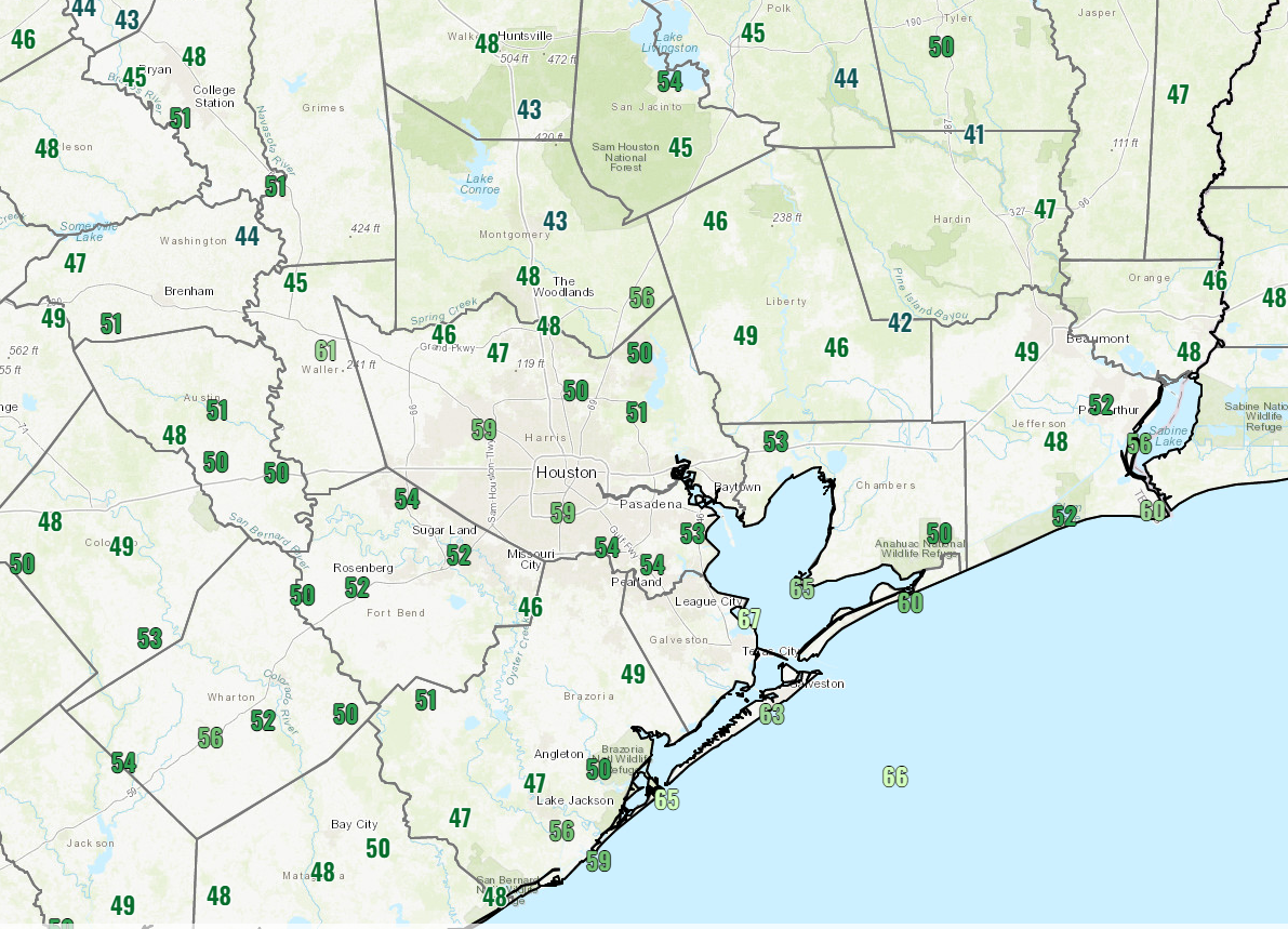
Today will be another chamber of commerce day for Houston with sun, low humidity, and mild temperatures warming from the 40s or 50s into the 70s. Some clouds could filter in as the day progresses, but that should be the only blemish.
Tuesday
Tomorrow looks to be our transition day from the blue bell weather to something a little more typical of later April. Look for humidity to slowly increase through the day, as clouds dominate and a few showers or a thunderstorm pop up. Showers could begin as early as around sunrise. Basically, have an umbrella with you tomorrow, though some locations may not get wet. Highs will nudge into the upper-70s or low-80s after a morning in the 60s.
Wednesday & Thursday
Both Wednesday and Thursday will tend to have a mix of clouds and sun, typical spring stuff for Houston. There will be a chance of showers or a thunderstorm on both days. Right now I think Thursday has a little edge on Wednesday for higher rain chances, but it’s not exactly a slam dunk. Just be prepared to dodge some scattered showers both days, meaning many places won’t see anything, while others could see some downpours.
Highs will be in the upper-70s to mid-80s. Lows will be in the 60s to near 70 or so.
Late week & weekend
It’s tough to say exactly how the end of the week and weekend will go. Back on Friday it looked like we had about a 30 to 40 percent chance of a cold front pushing through the area either Friday or Saturday. Today, I would say that is up to about a 50 percent chance or even a little higher. The trouble is that if the front whiffs, it would probably be because it stalled out nearby, keeping showers in the forecast each day, along with higher humidity. So, for now, let’s go for a 50/50 chance of a more refreshing weekend. Otherwise, expect a continuation of Wednesday and Thursday’s weather. We’ll try to get closer on this tomorrow.
Looking ahead
The specific forecast for Southeast Texas this time of year always gets tricky because of the reasons noted about regarding fronts that like to stall out. But, looking at the pattern over the next couple weeks, it would appear that next week runs the risk of being a bit cooler than normal (particularly the front part of the week).
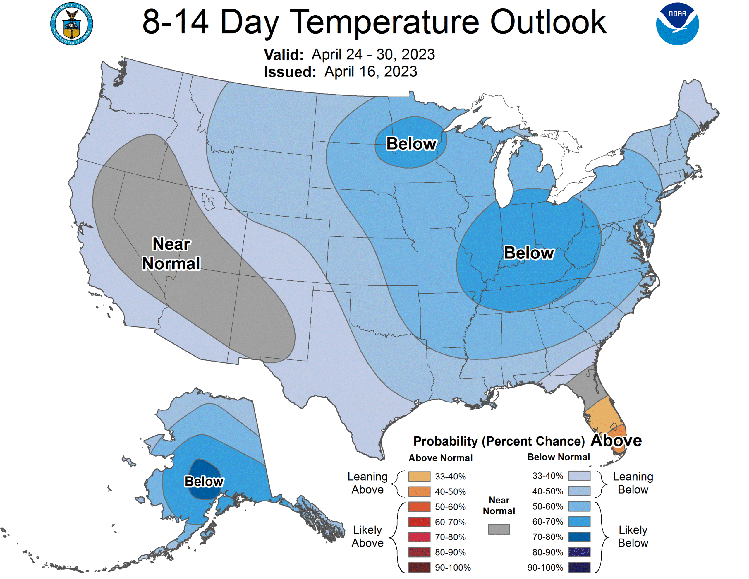
Rainfall is expected to be at or slightly above normal as well. It looks like spring.


We really need a good soaking rain in League City.
Agree KL. I can’t get excited about a high pressure dome yesterday and today and a capping inversion bust on this past Saturday evening….pre frontal storms to the East. Sunny cloudless days aren’t in it for me. If wanting to grow anything like grass or garden, the 8 1/2 inch rain deficit has got to be alarming. Hope it’s not more of the same 4th spring in a row.
I’d agree that Sunday was hands-down a beautiful day. One could have the windows open to air out the house and the AC didn’t have to run.
And, if today will be even better, be still my beating heart except I have to be here at work. Though, I do have a window.
Yesterday was stellar. I hope today I get a chance to get outside after work – thanks for the heads up!
Any first look at the MS150 ride weekend – April 29-30?
Too soon to say much of anything. But I would suspect we’d be coming out of the cooler pattern around then, so maybe a tailwind and warmer temps. But beyond that, shrug.
Hosting outdoor kids bday party in central Houston on 4/23 – will it be a rain out???
Hopefully the weather will be bright and clear for all the athletes, volunteers, and fans at the Woodlands Ironman this weekend!
Hi Matt — What happened Saturday night that the storms skirted the city and slammed points east? Curious about the meteorological reasoning. Also, can you weigh in on whether they did or didn’t expect all that rain in Fort Lauderdale last week/how so many were caught off guard?
Hey Heather. The storms formed on boundaries that were around, and it really was a bit of a game of luck as to how exactly they setup and spread out. I’m guessing that lingering boundaries from storms the night before were lingering in Beaumont and LA and then led to them getting hit a bit harder than most other areas. But that’s speculative. As for Ft Lauderdale…it was a bizarre event. Yes, there was a good chance of heavy rain that day in Florida, so from that pt of view, not a surprise. But, anytime you get 15-25″ of rain in a short time, you have to ask what happened. Some sort of storm got anchored to a boundary that wasn’t moving. There were a few other “under the hood” things at play that made it more likely. Forecastable? Not quite as much, but at least the “chance” of heavy rain and flooding was telegraphed.
Truly gorgeous weather!! Thank you for your accurate and well written coverage!!