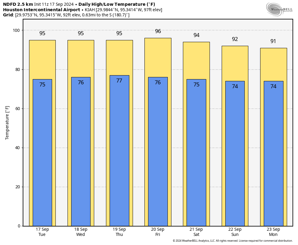
In brief: Houston will continue to see unseasonably warm weather, with high temperatures in the low- to mid-90s for most locations. The sunny pattern continues this weekend, with more late summer weather. There is the possibility of a cool front in about 10 days, but it is far from locked in. We also discuss potential tropical activity in the Caribbean Sea next week.
Tuesday
With high pressure in place, you pretty know what to expect with Houston’s weather this week, which is plenty of heat, humidity, and sunshine. High temperatures reached 96 degrees on Monday at Bush Intercontinental Airport, and that’s a good predictor of what will happen today, with mostly sunny skies, and light northeasterly winds. Rain chances are essentially zero, but there is a very slight chance of some brief showers along the sea breeze. Low temperatures tonight will drop into the mid- to upper-70s for much of the region.
Wednesday, Thursday, and Friday
More of the same. We’re going to see sunny and hot weather for the remainder of the work week. Need I say more?
Saturday and Sunday
The pattern continues into the weekend, however as the intensity of the high pressure system wanes some we’ll see a slight moderation in temperatures. Don’t expect much, but daily highs could drop into the low-90s, with plenty of sunshine. Nighttime lows may fall into the mid-70s. Skies still should remain partly to mostly sunny, with very low rain chances.
Next week
There’s not a whole lot of change next week, with fairly warm temperatures. Perhaps we’ll see slightly better rain chances to start next week, in the vicinity of 20 or 30 percent, I’m not sure. Some of the global models are indicating that a front may arrive by around Thursday or Friday of next week, but the signal is not yet strong enough that I’m buying it. However, it is possible. We’ll see.
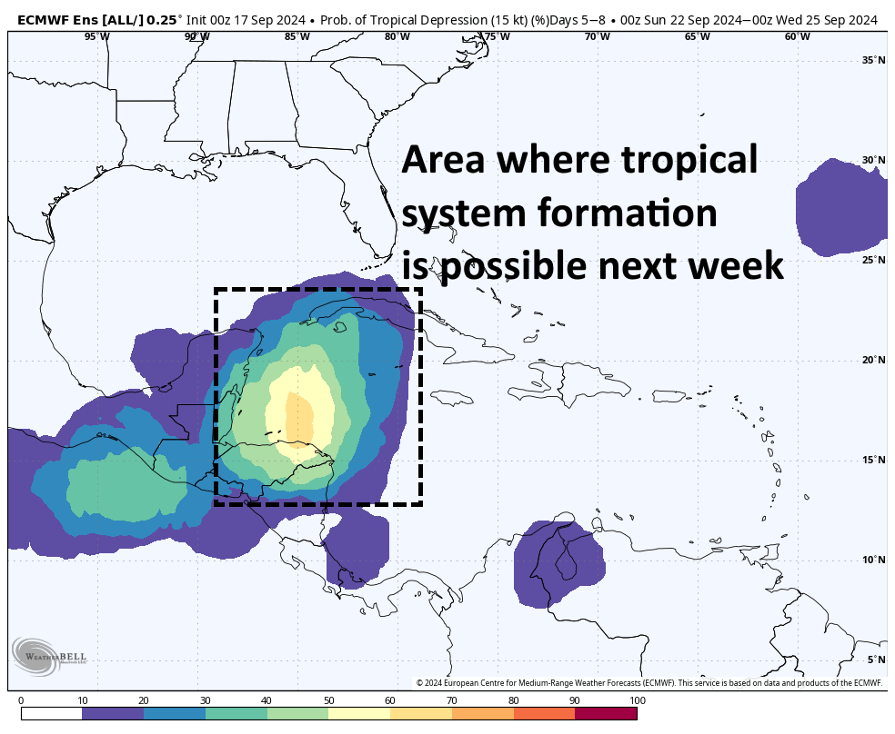
Tropics
A tropical system that has been absolutely soaking North Carolina has finally moved inland. Beyond that there’s not much to note that is presently active. However, most of our modeling guidance continues to highlight the western Caribbean Sea as a location where we can expect to see the development of a tropical low in about a week or so.
Beyond that there is not much sensible to say. This system could then track into the Yucatan Peninsula or turn north toward Florida or the eastern Gulf of Mexico. Yes, it could even move toward Texas, but at this point there is little model support for such an outcome—especially if the aforementioned front materializes. Nevertheless, at this time of year in the tropics we watch everything.

Well, looks like we are having 150 days of Summer afterall this year. It’s the 200 days of the other stuff I live for. We just need to get there, c’mon October!
I’m sticking to my guns that we will not get our first real front until October 6th or 7th. And I mean an actual cool front with highs in the 70s or low 80s with lows in the low 60s or 50s.
Yeah, extended forecasts I typically look at keep pushing any significantly cooler weather deeper into October, at this point around the 7th-10th, though with the way that’s continuially been pushed back since our last front, I’d probably add at least another week or two to that estimate.
crossing my fingers for the rumored front to arrive next week, I miss the cool mornings we recently got to enjoy!
another drought?
Am I the only one that can’t stand clear blue sky for more than a couple of days? Seriously. Dust clouds are returning.
It’s definitely nasty air, hard to breathe, but it’s better than tropical systems. Lesser of two evils.
So depressing. This is the time of year I really hate living in Houston and I was born and raised here!
Depending on your age, Marlie, the Houston you were born and raised in is very likely no longer anything like the same place. There is nigh on 7 million people in this ‘captive’ area now – and growing according to the latest Chronicle comment on how the area’s counties are growing.
It is too big now by far. I drove over to Columbus on Sunday and even as far as Brookshire vast acreage is being cleared for even more concrete. Even the one-time quiet country lanes between Fulshear and the Brazos river are being built over for housing. It would be nice to leave, but where to is the question, since the same pattern is being copied everywhere.
Born and raised in Houston area, 67 years now. Many storms (hurricanes) still fresh in my mind. Lived in SW Houston, Seabrook, Central NW, Cypress, and now in Magnolia.
.
The comments about Fulshear, and Brookshire goes without saying – they are both on main arteries on the west side. And heck, I can remember going on motorcycle rides over 20 years ago, and Fulshear being invaded. The same goes for Brookshire. Because Katy (which was invaded soooo many years ago) is so close, it’s only “natural” for Brookshire to blossom with more concrete.
.
Where to go? That’s easy. Our Cypress home was on three acres in a well-established acreage neighborhood – that area would not see further development. Same thing out here on our Magnolia 10 acres. The sister-in-law and husband have 50 acres outside Bentonville, AR, in a semi-mountainous area, so they will no doubt NEVER see concrete. Next, we’re considering 40-50 acres in the Anderson, TX area. So yea, there are places to move to, unless you have to live the urban life 🙂
(but keep in mind the popular hurricane pathways).
Yes, moving away is the answer. Easier if one has no contacts to hold one back – not mine, the wife’s.
I like the Bentonville area, it’s handy for the Ozark Highland Trail.
Odd people in AK though, I was hiking once on the trail and an old fellow came along with his rifle and said the wife wanted squirrel for dinner.
Is it actually unseasonably warm? Feels pretty typical for September…and the breeze has made it feel kind of nice. After last summer, you will not see me complain about highs in the low to mid 90s this time of year.