In brief: Continued wind in Houston today will finally break tomorrow as a cold front ushers in showers and thunderstorms in the afternoon. There is some severe weather risk on Saturday before we slowly clear out on a much cooler Sunday, setting up a gorgeous week to come.

Good morning, H-Town. Any day after an Astros “W” is a good day. The Astros are off today, and although the Rockets play an okay team from OKC tonight, today that W actually stands for wind.
Today
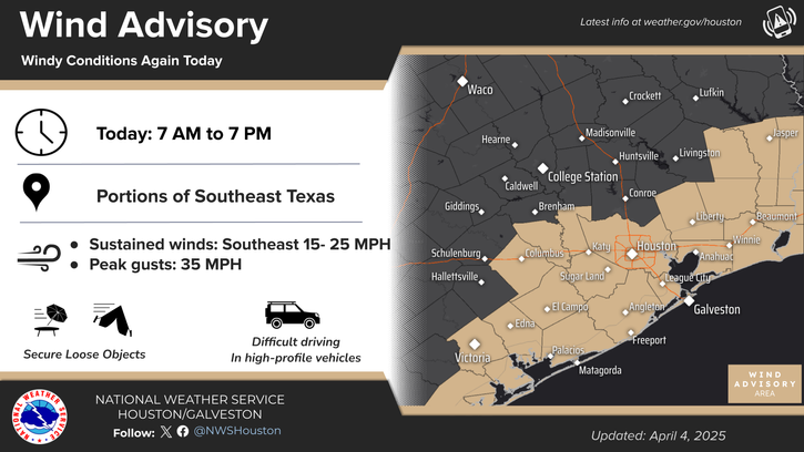
We’ll have to do some digging on how this spring has actually compared to previous springs in terms of wind when we get some time, but today is going to be no different. Wind advisories are again in effect today, and we’ll see southeast winds gusting as high as 35 mph. Oak pollen remains extremely high, and although we’re past peak now all this wind is going to keep carrying it around.
Outside of wind, expect another hot day today with temperature pushing well into the 80s and plenty of humidity. We get to track the potential for showers or a thunderstorm later this afternoon. Modeling has been trying to initiate storms near I-10 or just north before quickly lifting them northeastward. That may very well be what happens. As those storms move northeast, they’d be likely to intensify, and it’s not out of the question for a couple raucous storms to impact portions of Montgomery, Liberty, Walker, San Jacinto, or Polk Counties late today. We do not expect severe weather in the Houston Metro today. The highest severe risk remains up in far northeast Texas and Arkansas, where a moderate risk (4/5) is in place.
Saturday
After a continued breezy, warm, humid Friday night, we get to watch the potential for some strong thunderstorms on Saturday. The timing of the front hitting the area right now appears to be in the 11 AM through 4 PM window. It will enter the western parts of the area as a broken line of showers and some storms. As it crosses the Houston Metro, it will likely begin to ramp up a bit.

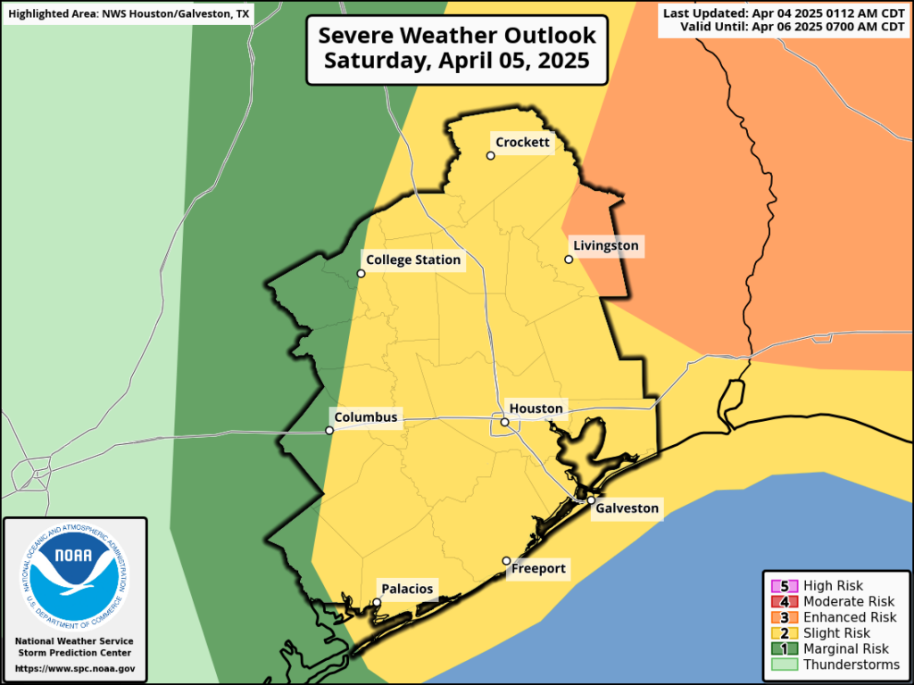
The Storm Prediction Center has us in a slight (level 2/5) risk for severe storms as this happens. The exact timing of the front may determine our odds of severe weather. A slower front would likely have more instability to tap into, whereas a faster front would hit earlier in the day with less instability. Generally speaking, the farther to the east you go, the better your chances of seeing severe thunderstorms. Whatever the case, we will update you Saturday morning (or possibly later today) with the latest. All severe weather hazards are on the table, including hail, damaging winds, and an isolated tornado or two. Additionally, any storm could easily dump 1 to 3 inches of rain in an hour causing some flash street flooding. Stay tuned.
Outside of storms, expect highs in the 80s again with lingering showers in the area Saturday evening.
Sunday
We will shift to a significantly cooler theme on Sunday. Some lingering clouds or even a few AM showers should give way to sunshine, but after a morning in the 50s or even upper-40s, we will limp into the lower or middle 60s for highs. It will feel awfully cool compared to how this week has been.
Next week
Bust open the windows! (responsibly, of course) It looks like Monday is going to be stellar. Morning lows in the 40s will be followed by daytime highs near 70 degrees. Tuesday? Nice; 50s to mid 70s. Wednesday? Nice; 50s to upper 70s to near 80 degrees. Thursday? Still nice! Warmer though with 80s. All we do is win, win, win no matter what next week. We’ll call that a “W” too.


A lot of us are planning to participate in the protests tomorrow, starting at 11 in Conroe and 12 in Houston. How bad do you think things will get? Enough to cancel? Are there safety concerns being outside?
Any time there are thunderstorms forecast, there are safety concerns. Lightning, wind, hail, and tornadoes are possible, especially the further north and east you go. Being outside would not be recommended during the storms.
Whatcha protesting?
As always with that group, they’ll be protesting “the current thing.”
Specifically we’re protesting the decimation of staffing and funding to the NWS, NOAA, and other science agencies without Congressional approval, based on the say of a group of individuals who were not elected or even appointed to the cabinet. Can’t imagine why anyone following a weather site would disagree with that.
That’s a pretty good cause in my book! Good luck out there, hope you make a difference
The First Amendment protects your right to assemble and express your views through protest. Not that you people care about rights.
LoL!
Doesn’t apply to FOTUS; why so the rest of us?
Ummmm sir this is a Wendy’s
Be safe and Thank you!☺️✌🏽🫶🏽
Don’t listen to them Ann. They can’t see what’s staring us right in the face.
You should spend sone time learning how current policies are affecting people financially Justin
Are you protesting the nice weather to come?
DBAA
LOL
These highs have really balled on the low side, thanks to stubborn clouds.
Lows in the 40’s? Unbelievable!!
Bust open the windows responsibly? What are you talking about? I always bust the windows open with my sledge hammer when the weather is nice. Doesn’t anybody else?
Lows near 80 degrees in early April. That is the state of our climate.
Maybe give it another read.
Whatever
So, we’ll be breaking wind tomorrow? What a relief!! /s
😂😂
Peeps can protest – “We
Can disagree.” – But allow
Egress through the streets.
So, how many times is the power going to go off-on-off-on because of the winds and lightning strikes?
We have community garage sales out by 99 & WPT scheduled for 9a-12p – how likely are we to get rain? I see that the front may hit the area from 11-4, so our HOA hasn’t made a call on whether to reschedule or not.
This site is useless. No updates in 12 hours heading into a weekend of major storms?
Apply for a refund then…..oh wait
With respect, there was literally nothing to update. Nothing changed from AM to PM. Had it, we would have updated.