In brief: There is a low-end risk for a severe storm or two on Monday evening across the area as cooler, drier air builds in. Thanksgiving looks stunning. We take a peek at the longer range today, as the hype machine builds for early December cold. While we believe there is a potential strong shot of cold coming, we do not currently believe it will be a damaging cold air outbreak.
Happy Sunday! We’re interrupting on the weekend to fine tune a couple points from Friday’s forecast and to discuss some of the potential cold weather risk after Thanksgiving weekend.
Fundraiser
Our fundraiser continues through this week, and then we close the merch store and proverbial Venmo! Thank you again to all who have contributed or bought some holiday gifts for friends or family yourself. Ten years in on this, and we remain so grateful for your support!
Heat records
First off, Friday’s 88 degree high ended up a record for the date and is now Houston’s hottest temperature on record so late in the calendar year, besting November 15, 1978 for that honor. Secondly, our streak of 80 degree days ended unceremoniously yesterday, with Bush only hitting 79 degrees. The streak finishes at 10 consecutive days, the 6th longest on record for November-February, with all others occurring in early November.
At Hobby, the streak continues, with 82 degrees yesterday marking 11 straight days. We also hit 90 degrees on Friday there, a new record for so late in the season and tying several days for hottest on record in November. 90 degrees was last set at Hobby on November 16th this year. This is the 3rd longest streak of 80s at Hobby and the longest so late in the year.
I feel like we’re just getting used to this by now, but statistically, this mid to late-November stretch will end up a remarkable one.
Today
No issues today. Enjoy the sunshine. Highs will be in the upper 70s after a low in the 50s in many spots this morning.
Monday
We’ll start the day off mostly cloudy with a little more humidity and scattered showers developing. They’ll be off and on and mostly light throughout the day. The much-advertised thunderstorms will arrive in the Brazos Valley and Aggieland during the late afternoon, bringing a chance of strong storms. That will then slide south and east, arriving in the northwest suburbs of Houston by about early evening. Most activity will lift to the north from there, bringing more numerous early evening storms up into Montgomery and Walker Counties.
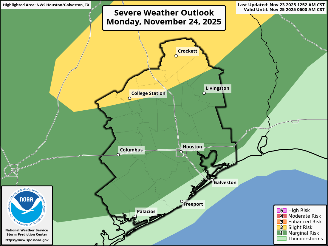
Then, the front itself pushes into the northwest suburbs with a line of thunderstorms after 8 or 9 PM. That will push across the Houston area over the next few hours, arriving at the coast by about 1 to 3 AM. Storms will be strong with some gusty winds and lightning possible, along with heavy rain. We are outlined in a marginal risk (1 of 5) for severe weather tomorrow, with a slight risk (2/5) up toward College Station.
Tuesday/Wednesday/Thanksgiving Day
Showers will probably linger in Brazoria and Matagorda Counties through morning on Tuesday. Slightly drier air and gradual clearing will allow temperatures to push back to near 80 Tuesday afternoon except where clouds and showers linger. A much stronger push of cool, dry air arrives on Wednesday, this without any rain. Holiday travel on Wednesday should have minimal disruption by car or probably by air with minimal disruptions at the Northeast hubs, Atlanta, and only some gusty winds in Chicago.
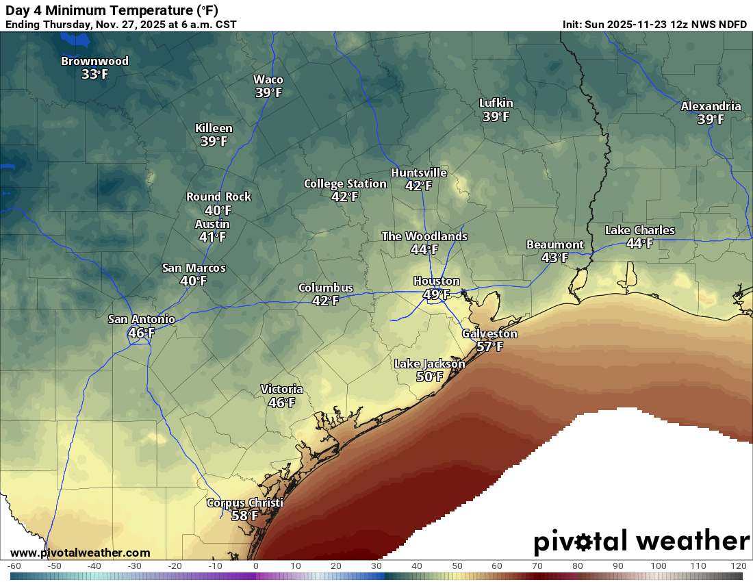
This should allow Thanksgiving morning lows to take a dip into the 40s almost everywhere. Thanksgiving Day looks perfect with sunshine and highs into the 60s.
Beyond Thanksgiving
The forecast gets sloppy next weekend with a chance of showers returning to the picture. Again, we are skeptical about this as it relates to the Houston area specifically. But suffice to say, there will at least be a chance in the forecast.
Beyond that, the European AI model has rankled some people over the last few days, as it has shown significant cold dumping into the Plains and eventually Texas. I’ve even seen the February 2021 freeze event thrown around (irresponsibly) on social media as an analog. Currently, the European AIFS model forecast shows temperatures as much as 15 to 20 degrees below normal (compared to 30 to 50 below normal in February 2021).
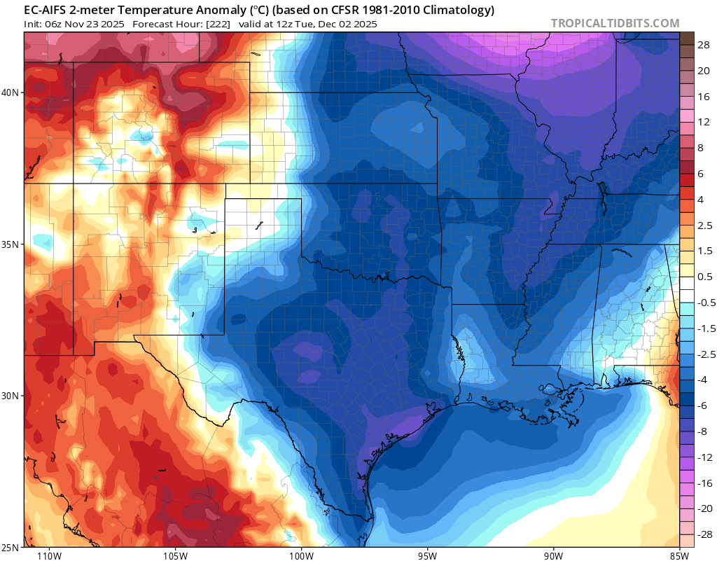
Doing some napkin math, this would probably yield upper 20s to low 30s in the Houston, cold but not alarming. Almost all other reliable model guidance is warmer than this. But let’s just say that, yes, our first freeze of the season is possible after Thanksgiving weekend. Will it be something we have to worry about beyond a light freeze? At this point I would say probably not. But we’ll of course keep watching trends. European AI modeling has done a great job with hurricanes but it has yet to truly prove itself in terms of temperature forecasting.
