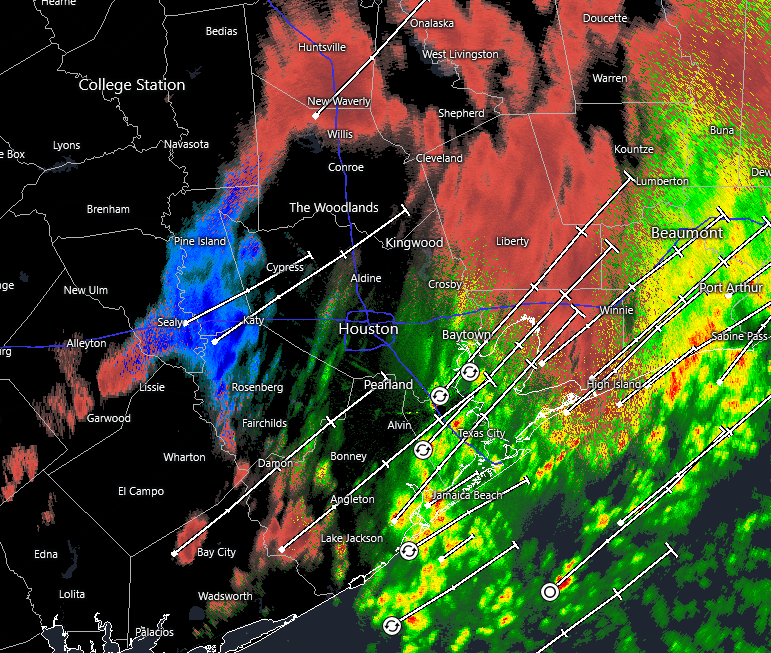
In brief: As we have been forecasting for days now about Sunday, it is a very close call out there for freezing precipitation in Houston this morning. Temperatures are falling to just about to the freezing level as a line of showers moves through, and accordingly we are seeing everything at the moment: rain, freezing rain, sleet, eve a little snow. Impacts are to be determined.
Winter storm status
Houston is now receiving its second, and final round of precipitation with this winter event. The precipitation is continuing as temperatures fall to around the freezing level in the city, and it is leading to varying levels of impacts on roadways. Fortunately, much of the precipitation this morning has fallen as rainfall or sleet, and this has spared us from power-line impacts due to ice accumulations. As of 6 am CT only a few thousand CenterPoint customers are without power.
We strongly urge caution with using area roadways this morning. Some areas north and west of Houston are ice bound, and there are reports of ice on several Houston area freeways. I would treat all overpasses and ramps as suspect as well, with the potential for icy patches. However, with air temperatures still in the 31 to 34 degree range, roads in the city are not freezing quickly. Many are still wet rather than icy.
Sunday forecast
The showers (and a few thunderstorms) should exit the region to our east by around 8 am. And that will likely be the end of the precipitation. After this we are going to see gusty winds from the north, perhaps as high as 30 mph this afternoon as Arctic air surges into the region. We may also see some sporadic sunshine. Temperatures today are unlikely to rise much above freezing. Areas along and south of Highway 59/Interstate 69 may reach the mid-30s for a few hours this afternoon, but areas such as Katy, Cypress, and Kingwood may max out at about 30 degrees this afternoon.
All of this raises difficult to answer questions about the state of roads later today. On one hand, the precipitation ends, and strong winds will have a drying effect on roads. However, the colder temperatures this afternoon, especially for inland areas, will lock any ice into place. We will know more in a few hours, but at this point my expectation is for icy patches on roadways, with issues on bridges and overpasses. However, we are now unlikely to see a widespread ice storm, which should be favorable for impacts later today and on Monday morning. Let’s see what happens over the next few hours. Again, if you can stay home this morning it is highly advisable, because as temperatures fall this morning water on roads can freeze.
With mostly cloudy skies we should see low temperatures tonight drop into the 20 to 25 degree range in Houston. Ongoing northerly winds at 15 mph, with higher gusts, will add additional chill to the air. Please protect pets from this very cold weather tonight.
Monday
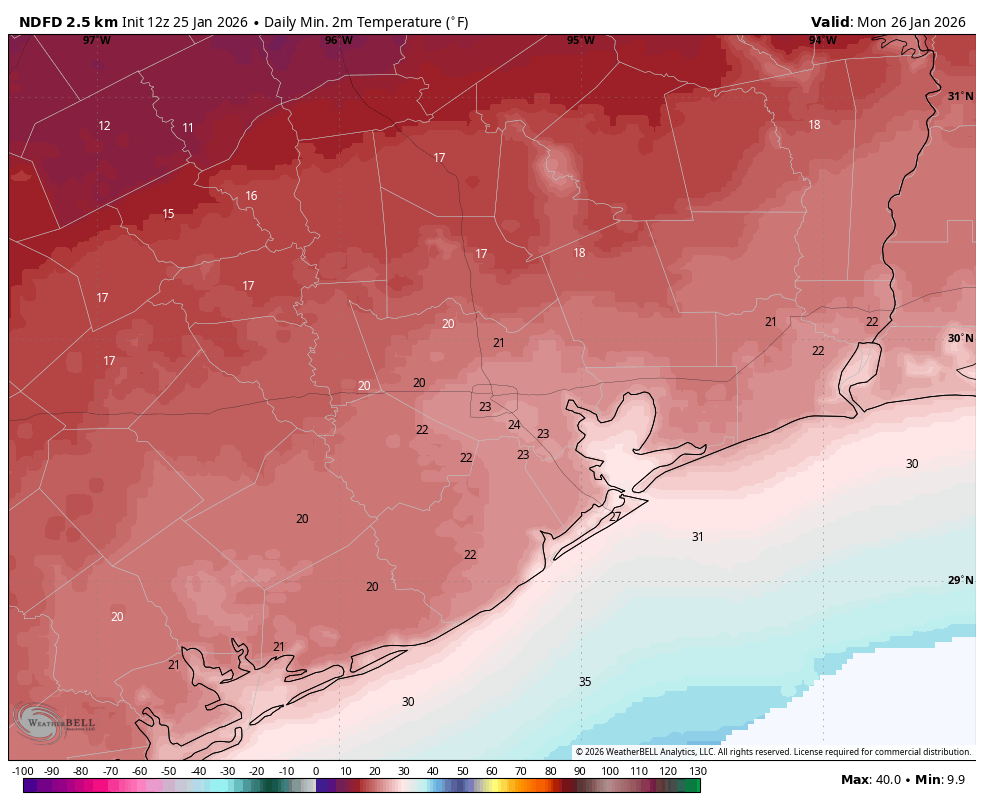
We should see clearing skies on Monday, but temperatures will be slow to warm with the ongoing advection of cold air into the region. By around noon, or shortly after, we should see temperatures rise above freezing for a few hours, reaching 35 to possibly 40 degrees for much of the region. Lows on Monday night will be similar to Sunday night, still very cold, but with clear skies and lighter winds.
Tuesday and beyond
By Tuesday we’ll be comfortably in the 40s for high temperatures, and then the 50s through Friday. After this time another Arctic front may be in the cards next weekend, although it’s not yet clear whether it will be as cold as this air mass (probably not?) or as impactful in terms of wintry precipitation. We shall see.
Our next post will come by around 2 pm CT this afternoon, when we will take a closer look at roads and electricity production statewide for a very cold night across Texas.
