In brief: After an extremely warm spell over the last 10 days, some relief arrives this week in the form of a decent front (for September). Helpfully, we’ll also see some rain chances on the rise, although we’re not going to see inches of precipitation. The weekend looks sunny and warm.
Beginning to transition to fall
Houston’s streak of days with temperatures above 95 degrees continued through the weekend as our region’s anomalously warm pattern continued. We may get day number 10 today. However, some relief really is on the way the a cool front arriving on Wednesday, with some decent rain chances, and then cooler weather for the rest of the week. It’s still September, so don’t expect miracles. But daytime highs in the 80s and drier air will make for a nice pattern change for a few days. Another front is possible during the first week of October—so while it won’t feel cool and crisp like fall, we’re definitely entering a pattern during which we’re beginning to transition to fall.
Monday and Tuesday
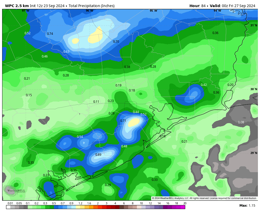
For the next two days we’re going to be stuck in the cool front waiting room. Highs for most locations should top out in the lower-90s, but some inland locations could reach the mid-90s again. Skies will be mostly sunny. What will change is that increasing atmospheric moisture levels will lead to some decent rain chances. Overall odds will be best for coastal locations, perhaps as high as 50 percent on Tuesday. The likelihood of rain will be lesser for areas further inland.
Wednesday
Some time on Wednesday we should see a line of showers, possibly broken, heralding the arrival of a front. Highs on Wednesday will likely still reach about 90 degrees, with sunny skies following the front’s arrival. Lows on Wednesday night will drop to around 70 degrees in Houston.
Thursday and Friday
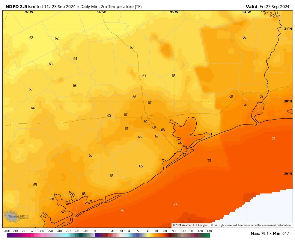
These will be a pair of days with high temperatures likely in the mid- to upper-80s for most locations, with sunny skies. Winds from the north will knock dewpoints into the 50s, which will mean the air feels much drier and the mornings and evenings will be quite pleasant. Low temperatures will fall into the mid- to upper-60s for most locations. This is the way of these September fronts—they tease us with fall, they never last long, but after a long summer even a modest change feels great.
Saturday and Sunday
The weekend should be warm and mostly sunny, with rising humidity. I cannot rule out some rain chances, but I’d put them at 10 percent or less, so probably not impactful. Highs will be around 90 degrees on Saturday, and perhaps a tick warmer on Sunday.
Next week
We are likely going back into the low-90s, with sunny skies, for the first half of next week. However, there is a decent amount of support for another front by next Wednesday or Thursday. Please just pencil this one in, however, as it’s still not a sure thing.
Tropics
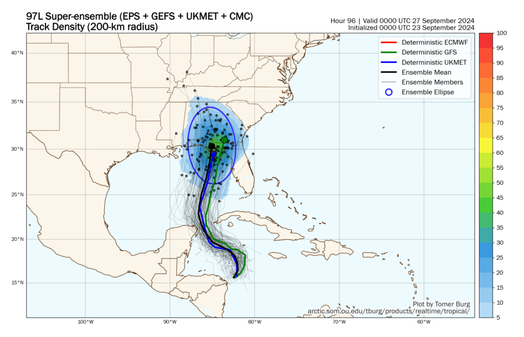
A tropical system is likely to move into the Gulf of Mexico on Wednesday, and it may strike Florida by as early as Thursday evening. It poses no threat to Texas. However, I am increasingly concerned about this becoming a powerful hurricane in the very warm eastern Gulf of Mexico. We’ll have continuing coverage of its development and impacts on The Eyewall.
As for what’s next for Texas and the tropics, be sure and check Space City Weather tomorrow for an update on that.

What is the intensity ceiling of this potential storm? Any chance of RI before landfall, similar to Michael ’18?
Have a Destin trip planned for this weekend, and while we will be on the clean side, I don’t want to travel if a major hurricane is anticipated.
Not a meteorologist, but follow a ton of them over on Twitter and while they are trying not to fall into a hype pit, almost all of them are worried about it being a 2 or 3. Little shear, a ton of moisture ahead of it, and a record hot Gulf are all not great
Like Josh mentioned, many/most intensity models push into the cat 3 range, with one or two a cat 4. So it’s looking to be pretty potent at this point, given that a closed center has yet to form. But there’s a lot of warm open water for it to eventually transit.
So glad for the front!
I agree completely. The summer has overstayed its welcome.
Any indication that TS John will make it into the Western Gulf?
Cary: I hope not, although it “could.” The National Hurricane Center shows John dissipating in 48 hours. Movement is slow after landfall in Mexico, and shows a hook to the west. It doesn’t look like it will.
Can you please tell me why if yesterday – the 22nd – was the first day of fall, the 26th shows equal night and equal day on my sunrise/sunset chart? Is it due to our latitude?
Thanks!
It looks like there are a couple reasons: 1) the latitude, and 2) the definition of sunrise and sunset.
https://www.timeanddate.com/astronomy/equinox-not-equal.html
If the Sun were a point source of light then equilux would coincide with the equinox. But it’s not. It’s a disk and sunrise sunset is defined by the top of the disk at horizon. Also atm refraction keeps the disk higher visually than it really is. I learned this observing the sun daily over Lake Pontchartrain of all places. Good question.
The equinox is the day when the sun is on the celestial equator. As I understand it, day begins when the first bit of sun comes over the horizon, and day ends when the last bit of sun disappears under it. Because of that time taken, the equinox still has official day a bit longer than official night.
“Cool front waiting room” I like that lol. I stay in the cool front waiting room from mid May all the way to late September.
And this is why September is the worst month. Not a fan of the fall tease.
Definitely how I feel as well, August may typically be hotter, but you also know that’s what to expect.
People need to stop asking “is this gonna cancel my trip” or “what about my cruise”. Peoples lives and property are at risk with these things. Get it together smh.
I think it’s of course a good thing to point out that there are people in real danger with these storms. It’s always good to have empathy.
Someone posted that they have travel planned in an area that might get a storm. This could mean he’s putting himself in danger. I’d like empathy for him as well, as he might lose money if he needs to cancel, or he might have to stay inside if it’s rainy.
Is Houston going to have a problem from the leftovers of tropical storm John crossing Mexico into the Gulf and regenerating into a cyclone?
If it were to try, the Oaxacan Mtns would likely stop it from forming. Don’t worry about it.
Matt J: Not likely. The National Hurricane Center shows John dissipating in 48 hours, slowing down after landfall and hooking to the west as it dies out.
Hoping tomorrow’s post is what I think it is!!
I think so too but my husband says no way!!! I hope I’m right.
Waiting for someone to post “Should I cancel my flight to Panama City?”