In brief: The holiday weekend should be mostly fine (albeit hot) in Houston. Rain chances will rev back up a bit late Sunday night and Monday morning and again deeper into next week. For now, Memorial Day Monday looks unsettled but perhaps not a total loss.
Memorial Day Weekend
Let’s jump right into the big holiday weekend. First off, if you have plans in the Houston area or on the coast today and tomorrow, you’re more than likely going to have no issues whatsoever. There could be a passing shower or storm in the region, but it would most likely be extremely isolated. The vast majority of us should see absolutely nothing.
If the odds of rain on Friday and Saturday are something like 5 percent, then I think Sunday’s odds nudge up to about 10 percent. Again, the vast majority of the area will be fine on Sunday. But there should be at least a few more pop-up showers or a very, very isolated thunderstorm.
So what about Monday? Well, that’s the trickiest day of them all this weekend. Models have been pretty consistent about trying to bring a cluster of thunderstorms in from the north on Sunday night into Monday morning. We could then see a break in the action followed by another round perhaps on Monday night. We’ll see if that’s how it unfolds. Eric or I will throw an update out there on Monday morning with the latest thinking. I would not postpone any plans at this point, but I’d be mindful that the chance of rain is highest on Monday.
Region-wide holiday weekend weather
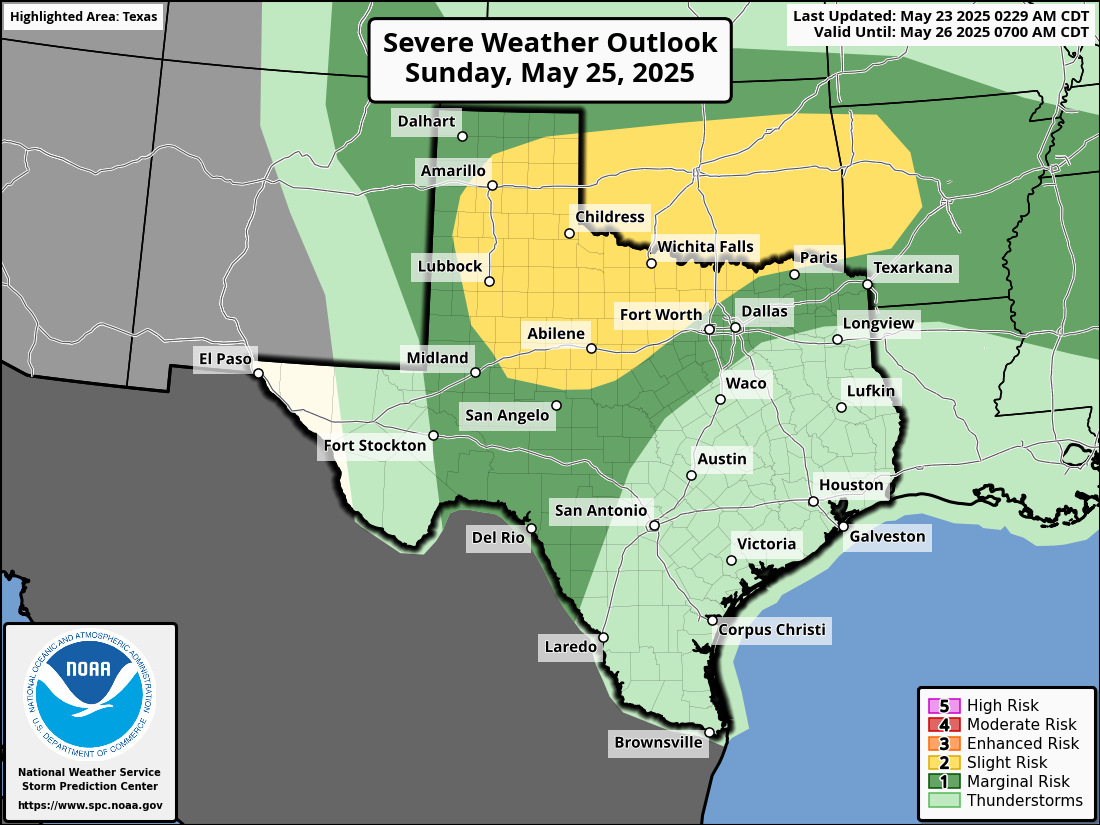
If you’ll be traveling across Texas this weekend, there should not be a whole heck of a lot to bother you today or tomorrow. Isolated storms could be on the stronger side between the Permian and the Panhandle. And there’s a slight (2/5) risk of severe storms near Wichita Falls on Saturday.
Sunday is a little more interesting with the potential for more severe storms, especially from the Caprock into North Texas.
The remnants of those storms are what we could see in the Houston area late Sunday night or Monday morning.
And then for Monday, that chance of severe weather moves more into Hill Country and Central Texas up through DFW. Basically, between Houston and Dallas, there will be some severe risk Monday afternoon and evening.

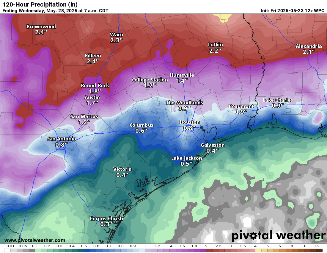
Memorial Day Weekend has had a history of flash flooding in Texas. At this time, the risk of flooding looks to be about average given the forecast; there are no significant flash flooding concerns right now.
Holiday weekend temperatures
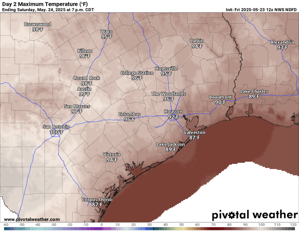
As for the temperatures? They look hot. The combination of heat and humidity will make it feel like 100 to 105 degrees at times tomorrow through Monday. Actual highs will be in the mid-90s, with morning lows in the upper-70s. It will be cooler by day closer to the coast and a bit hotter farther inland.
Next week
Temperatures will back down a bit due to clouds and rain chances next week. While it won’t rain everywhere or every day, there will be a good chance of rounds of thunderstorms throughout the week.

I’m ready for next week. I’m so over this July weather in May crap.
I’m right there with you buddy. And not much rain either….PS to Glenn: you promised us a rainy May with the ‘Glenn Algorithm’. What’s up with the rain forecast; there be no ridge over us. Atmosphere is just too stable I guess – hazy, hot, humid. Gad.
We were above average on rainfall and right on the monthly average for temps during the first two weeks of May. After that my complex algorithm broke down and performed poorly…
But I’m tweaking it for June and will try again…
More better variables! Lol 😂
Man, the cracks are already starting to show in our yard. I hope the rain forecast comes through. Have a good long weekend everyone!
I don’t want to hijack the thread but if you think it’s been windy this spring it has. Nationwide it has been the windiest spring in decades. And the winds have increasing since 1980.
Eric Snodgrass over on YouTube has an interesting video if you are a weather nerd and some longer term pressure pattern changes that may be the culprit.
Yes! Thanks for posting. I’ll be checking that out.
These temperatures are intolerable. The only people who could care less about the heat are those who never go outside, and the billionaires and if I was one of those ‘special’ people I could have houses all over the place and right now I would be cycling around the Rockies from my Aspen mansion.
We (9 of us) played 2 hours of pickleball outside this morning from 8 to 10. We’re all in our 60s.
hug you are special 💓
Well, two posts earlier, but nothing showed up.
Anyway, up here in Magnolia area, we got a strong downpour with lots of thunder. Lasted close to two hours. Also, a power outage for almost the same amount of time.
(i guess the power outage affected SCW website).