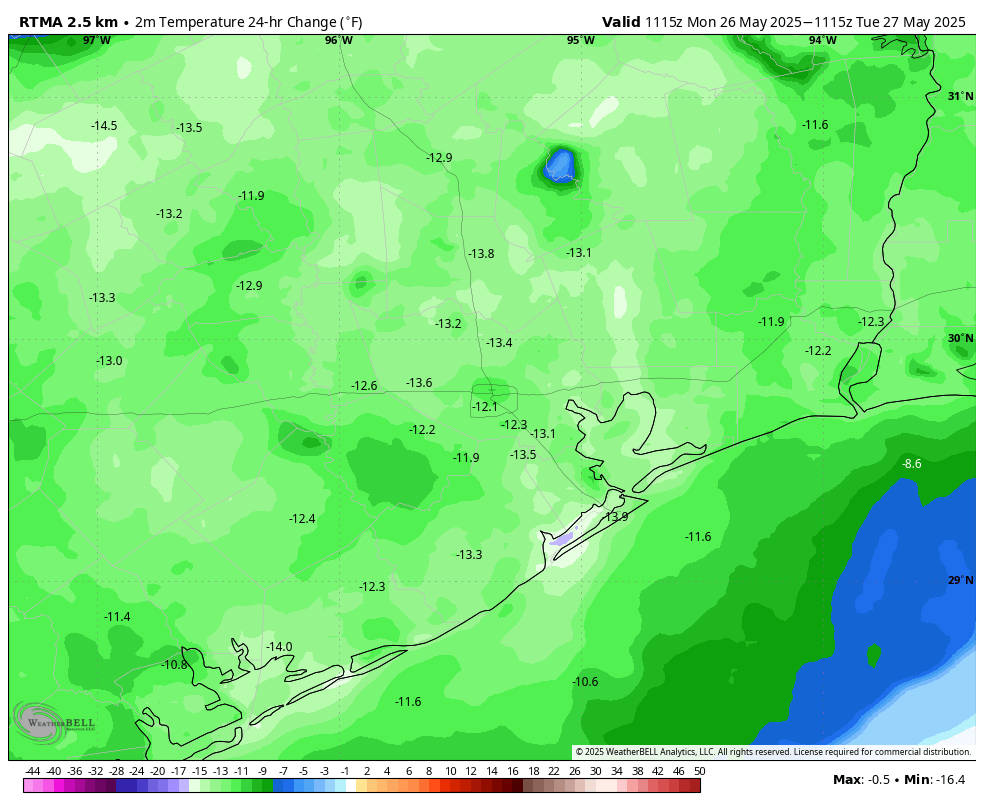
In brief: Houston rocked and rolled on Monday night as a storm system rumbled through, but in its wake we’re seeing calmer and cooler weather this morning. The reprieve will probably last for 12 to 24 hours before widespread showers return on Wednesday and possibly Thursday.
Monday night’s fireworks
As expected, a line of storms roared through the area overnight. Most parts of the Houston region received a good soaking of 1 to 2 inches of rainfall. In addition to the front, there were straight-line wind gusts of up to 40 or 50 mph in some locations as the storms blew in. There are a few scattered power outages in the Houston area, but the stronger cells went well north of the city, where electricity issues are more widespread this morning.
You may have had an issue loading Space City Weather last night, and for that I apologize. We had website issues unrelated to the storm, but they should be fixed now. Thank you for your patience.
Tuesday
Light rainfall is lingering near the coast this morning, but these showers should end by mid-morning. Following Monday night’s storms the atmosphere is pretty well worked over, and I expect a fairly quiet day in terms of showers and thunderstorms. Most of the area should see partly sunny skies and highs around 90 degrees today as a result. We might see a few scattered showers pop up late this afternoon or evening, but generally expect calm weather today and tonight. Lows tonight will only drop into the mid-70s.
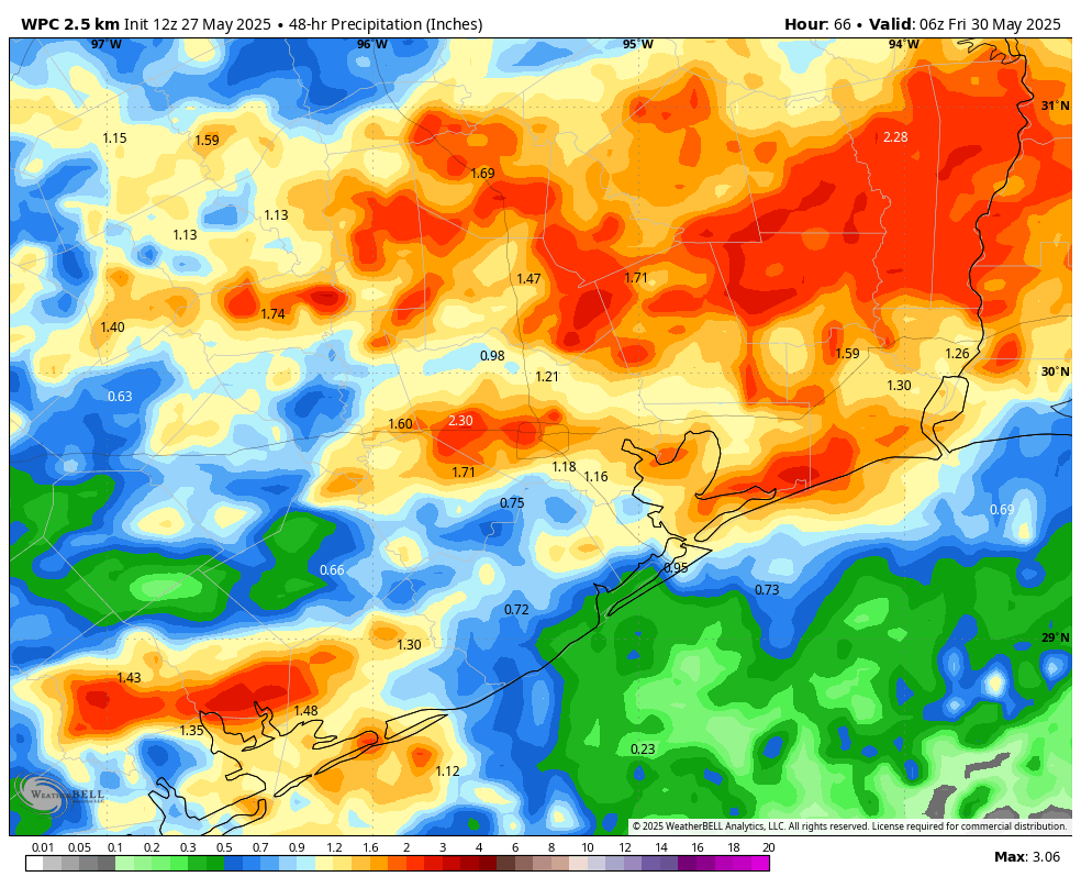
Wednesday and Thursday
Our overall pattern will remain unsettled through at least Thursday, and therefore we can expect both of these days to produce a healthy chance of showers and possibly some thunderstorms. At this time the likelihood of severe weather is lower than what the region experienced on Monday night, but I’m not ruling anything out, especially on Wednesday. I expect most locations to pick up an additional 0.5 to 2 inches of rainfall through Thursday. High temperatures will be in the vicinity of the upper 80s with warm and muggy nights.
Friday
A weak front will approach the area on Friday, and this may spark an additional chance of rainfall. However at this time any showers look to be mostly light. Rain chances will likely ebb during the afternoon and evening hours as drier air slowly filters in. Look for highs in the upper 80s on Friday, with partly sunny skies, and lows dropping to around 70 degrees.
Saturday and Sunday
Our weather this weekend will depend on how that front, stalled near the coast, waffles around. My best guess is that we’ll see partly sunny skies, highs of around 90 degrees, and a slight chance (maybe 20 percent on Saturday and 30 percent on Sunday) of showers and thunderstorms. We’ll see.
Next week
Most of next week looks hotter and sunnier, with highs likely in the lower 90s and low rain chances. So, pretty normal for early June, most likely.

Yesterday, close to noon, it rained (Magnolia area) for about an hour, plus temps dropped to lower 70s.
Then last night, about 11.30pm, the high winds blew in, small trees were bent over about 90 degrees, then the rain and horrible lightning. Then at one minute before midnight, the power went out. Finally restored at 4.02am. 😐
Would it be possible to develop a Wind Scale, similar to your Flood Scale? If not, would love to get a mph range when you mention “damaging winds.” More specifics on wind speed, intensity and duration, when possible, could help us prepare/secure vulnerable items. Thanks for all you do!!
That was terrible last night.
And it wasn’t expected to have storms ‘roar through’, just stuff ‘north’ and some ‘potential”.
😶
I hope everyone is ok.
I must have slept through it or the thunder wasn’t loud enough near downtown to wake me up! Two of my plants were blown over this morning, though.
💓🌱💓
I’m not okay. It woke me up and ruined my sleep so I’m exhausted!
I couldn’t read comments last night! Figured for sure Aggie would tell us what it looks like in Magnolia. A good vanguard for the Metro area. But I thought Eric’s X post 10P with words playing on video was very effective! I didn’t think to look there till 1A….got plenty of severe alerts from my phone however. Looking over at Austin before bedtime I knew something potential was coming. If you’re snoozing thru these things w/o radar check then heaven help you. It can get pretty bad here (hail, straight line wind, rarely tornado) but didn’t last night. Thanks be.
Yea, @DJ … believe it or not, as the storm was passing thru last night, I tried to post a Comment with details of the storm, but I kept getting Server Error 500 (as admitted by Eric in this article). That’s why I draft my replies in Google Notes first, then copy paste into a Comment (there’s server probs here about 60% of the time) 🫤
I knew you did! But I could not access anyway. A Cloudflare error. There were no realtime comments at the X post either. Apparently weather nerds do not use X. I think the comment gallery here is a gem in the rough, along with the new messaging technique Eric used last night. Rather more useful than being alone in a storm or a drought. After last year, seeing the wind suddenly lurch from zero to 50+ is unnerving.
A hidden gem? What are you on, crack? The comment section here is 50% people falling over themselves thanking Eric/Matt, 45% whining about the temperature or the lack of rain, and 5% unhinged right wing climate denial. It’s on the same level as local news sites, and if comments went away tomorrow the app would be better for it.
You forgot the people vacationing next week that want to know if a direct hit by a hurricane will interfere with their plans. Eric, should I cancel my flights?
Nice way to end the torrid month of May with some rains to fill the cracks in the dirt.
Mayyybe a more reasonable summer awaits. Mayyyyybe?
Only if we get timely rains. If it’s dry and dominated by high pressure, then it will be just like 2023 or worse. Our baseline average temperatures for summer have been made hotter due to the warmer Gulf and hotter land temperatures in the tropics. That is why we are already seeing weeks of highs in the mid-90s with lows in the 80s in May now. The only way for the entire summer not to be sweltering is to be stuck under a persistent rainy pattern.
Regardless, overnight lows and heat index values will continue to be much higher on average than they used to be decades ago. And for the “it’s just the urban heat island effect” crowd, summer nights are averaging warmer in rural coastal areas than it used to as well
Blah blah blah blah blah blah blah blah blah blah blah, climate change
A more reasonable summer? Not a chance.
Summer forecast : Sunny , unbearably hot and humid. No rain except for numerous hurricanes.
Blackhawks Brutha.
If we have a torrid, sunny, rain free summer, than hurricanes won’t even think about coming this way thanks to a death ridge if that is to set up that way.
Come on have a heart ,let me embrace my delusion at least for a little while.
Nothing wrong with little bit of optimism right??
A death ridge that kills all of our hurricane chances would be great!
Yeah but a death ridge that kills all our trees and foundations would not be great. How about a happy medium where we have frequent rain showers with no hurricanes and no extreme heatwaves? I know that’s to much to ask for in this climate we live in now.
KIAH time series shows three 60 mph gust readings right around 12:30 a.m. Lotta mass transfer of air going on last night.
Rain but no strong winds here. With all the clouds, A/C didn’t run much yesterday for which my wallet is thankful.
Here in west Cypress, by outlet mall, scary!! PTSD from the Derecho! Hunkered down in the closet as it approached with 50 mile an hour winds!! Wish besides the flood alert, there was a wind alert. Strong gusty winds don’t cut it for me. Lights went out and that of course doesn’t help. However, seeing that y’all didn’t post anything prior, gave us peace of mind. Thanks for the no hype but facts weather report.👍
14 Hours without power. Certainly wasn’t expecting that based on yesterdays forecast.
Wow! Hopefully power is restored soon for you, Bob!
Centerpoint’s outage map is working again and gives areas affected and estimated times for restoration
It’s back on thankfully. We’re with Entergy not centerpoint; a bit further north.
Yeah we were without power for 16 hours in Pinehurst. Downed power line. Finally got a standby generator in December. Worth every penny.