In brief: Hot and humid weather with daily shower chances awaits Houston over the next several days, typical for August but perhaps encroaching on 100 degrees at times. Today, we also dive in deep on the tropical noise that’s been percolating on some weather models.
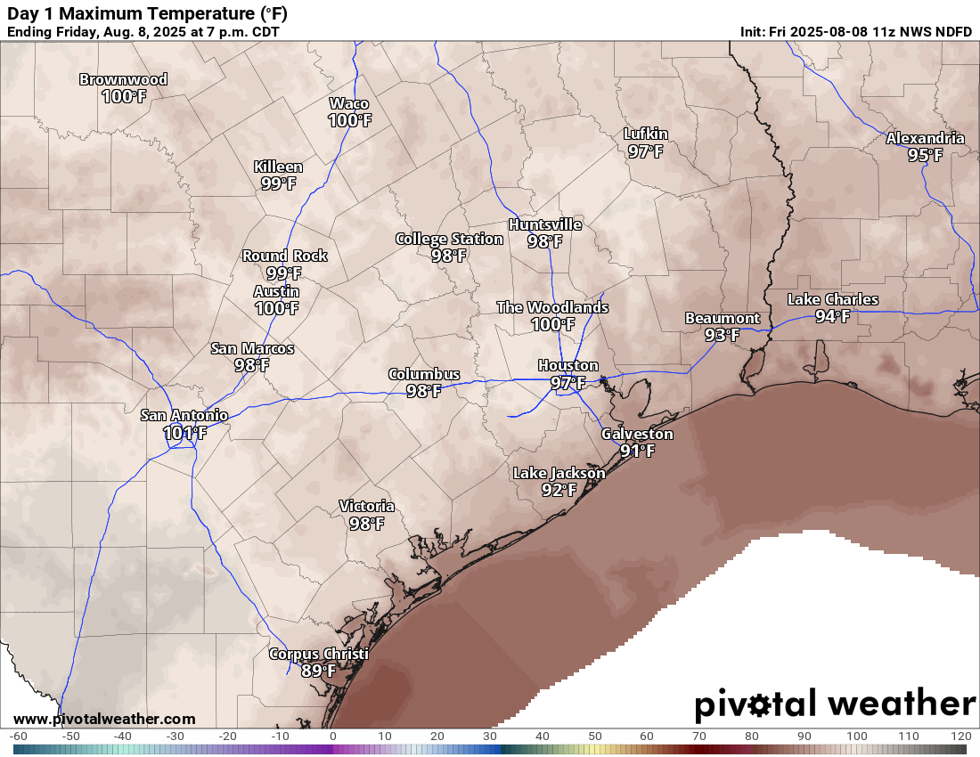
IAH hit 100 degrees again yesterday. Before you go stand outside Terminal B with pitchforks due to construction the perceived hot bias, there were a string of 99s and 100s yesterday recorded across the north and west side of town. Wednesday’s 100 felt a little less valid. But again, compare IAH to IAH, not to the rest of the city. We saw mid to upper 90s mostly, and we’ll probably do it again today. Nothing unusual for August.
Today
We’ll have one more slightly hotter than usual day today with highs approaching 100 degrees in spots, especially north of I-10. Isolated to scattered showers and thunderstorms are likely with daytime heating again, and any of those storms could produce some brief downpours and the potential for some gusty winds.
We may still have residual haze, especially this morning. That’s due to wildfire smoke from Canadian wildfires. This is a problem that much of the country has been dealing with at times in recent years.
Weekend
Both days should be fairly typical for August. We’ll see highs in the mid to upper-90s, possibly leaning more toward mid-90s on Sunday with slightly higher coverage of showers and storms. But, sunny, hot, and humid with daily isolated to scattered downpours and thunderstorms.
Next week
There’s nothing particularly notable about next week’s weather right now. It looks like we’ll have a few isolated to scattered showers or storms each day, especially on Monday or Tuesday. Temperatures may try to rebound back closer to the upper-90s again. But overall, it looks like very basic August.
Tropics
First and foremost, we’re good here for the next 7 to 10 days in Houston. We’ve got no concerns noted on modeling right now.
All that said, it’s getting to be the time of year where we do start watching more and more things, even some of the innocuous looking ones. We’ve had some deterministic (operational) model guidance (the GFS, the Euro, etc.) go crazy in the day 14 to 16 timeframe lately. This bears repeating. The day 14 to 16 timeframe. Deterministic modeling has virtually no skill at that timeframe. So, while we are certainly empathetic to people getting a little unnerved when they see bad things in that timeframe, Eric and I both are realists and recognize that those runs, even if 2 or 3 in a row show something similar, are somewhat meaningless. Put another way, if I had a buck for every time a deterministic model wrecked a major Gulf Coast city on days 14 to 16, I’d be getting wrecked on some tropical island somewhere far, far away living the dream. I’m just saying!
So what do we do instead? We look at ensemble guidance for clues. What can the ensembles tell us about the potential for a tropical system in a more distant timeframe? Ensemble modeling is where you take a single model and run it 30 to 50 times but tweak the initial conditions, or what the model starts from. We can’t get a perfect snapshot of the entire atmosphere over the entire globe, so we have to improvise a little. Ensemble guidance is that improv.
Okay, let me show you a perfect example of this. Here’s last night’s GFS operational model for hour 294, which is day 13.
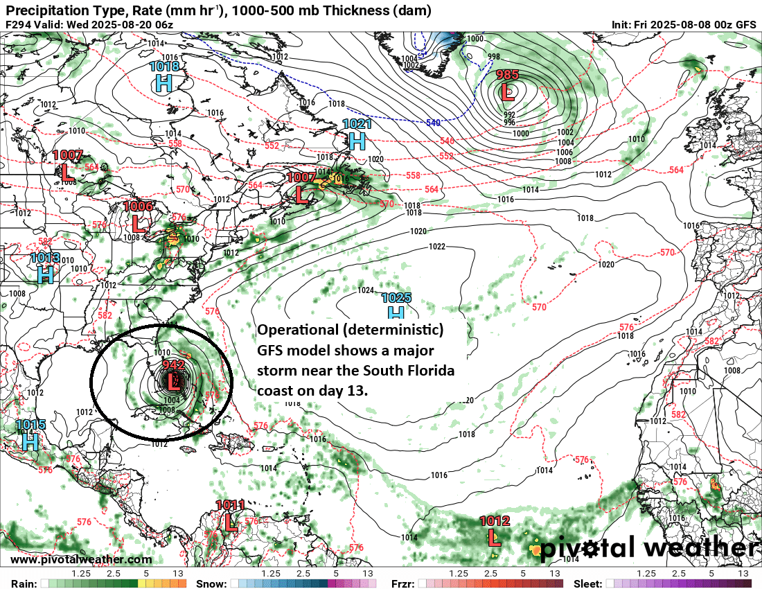
That’ll get your attention! And it has been showing this for a few days, though it varies in location between the Caribbean, the Carolinas, and out to sea. But what do the ensembles show?
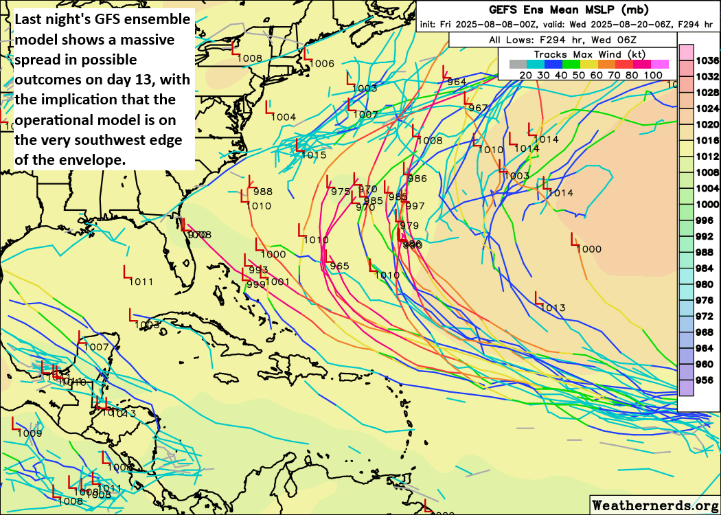
Not all lines on a spaghetti plot chart are created equal. Some of the lines above may be ensemble members that are slightly more skilled than others. That’s a tough lift to figure out specifically in every situation. But the point is this: Yes, the GFS operational model may be right! But according to the ensembles there are a bunch of other options too, including many that go out to sea and a handful that come into the Gulf.
I show you this for a couple reasons. First, I want you to recognize that the scary images you often see on social media are almost always from operational models. Second, when you look at the ensemble guidance, it offers a far more nuanced take on all this that suggests the operational models are just one possible solution of many. We go through this exercise every season. It’s the same culprits from the same places with the same intentions. They’re basically preying on people’s fears to drive engagement under the guise of “we’re not saying this is a forecast (it is), but we want to just let you know what’s out there!” In reality, the picture is nuanced, complex, and not at all straightforward. A deterministic model showing Armageddon on day 13 does not make that scenario any more likely than any of the possible outcomes on the ensemble chart I showed you above. Hurricane season is a months’ long marathon. We just want you to keep your sanity.
In this specific situation: Yes, we should keep an eye on this tropical wave as it comes west over the next 10 to 12 days. It is August, and we should keep an eye on all tropical waves this time of year. Rest assured, if there’s a threat that seems realistic to Texas, we’ll be talking about it here well before it happens. You can also use The Eyewall to follow along with more of the day-to-day details.
