In brief: Summer is not over. In today’s post we explain why the end of September has been very hot, and why that’s not going to change much this week. We’ll also take a look at the weekend forecast, when there are a lot of outdoor events in the metro area. Finally, could we see a real front next week?
Wake me up when September ends
Fifteen of the last sixteen days in September have recorded high temperatures of 90 degrees or higher. (On the single day that did not, the high reached 89 degrees). This has occurred despite a front coming through a couple of days ago.
Why has the daytime heat persisted? Partly because our early fall fronts tend to bring drier air, but not much colder air. So our days remain warm because drier air heats up more efficiently. The primary benefit of the front, however, is that it has taken about 10 degrees out of nighttime temperatures, which has been nice.
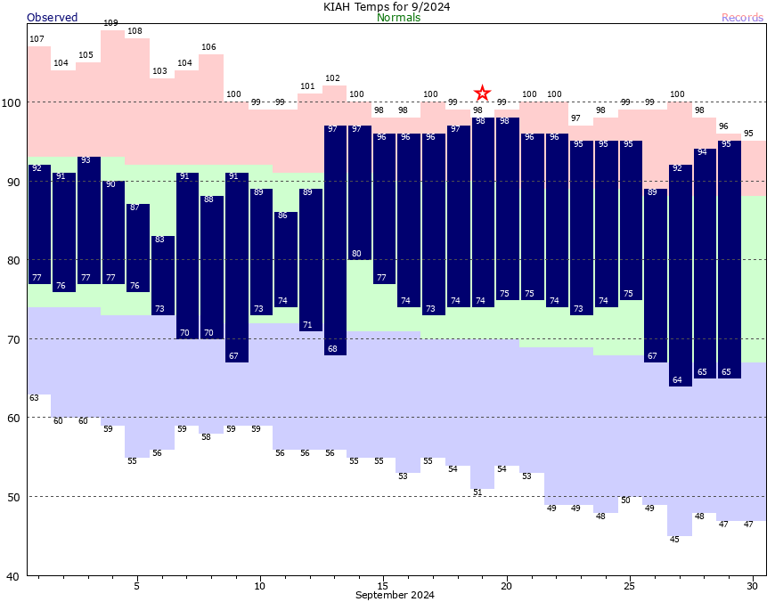
October is not going to bring immediate relief, but as our air modifies somewhat this week with higher humidity, we’ll see slightly cooler days by around Wednesday, and correspondingly warmer nights in the mid-70s. Later this month we can almost certainly count on more emphatic fronts to bring cooler daytime weather.
Monday
High temperatures today should, once again, reach the mid-90s for much of the metro area away from the coast (where highs will be a few degrees cooler). Skies will be sunny, with almost nary a cloud in the sky. Winds will be light, generally from the northeast. With dewpoints mostly in the 60s, the air won’t exactly feel dry, but it won’t be Houston-humid either. Lows tonight will drop into the low 70s for most locations.
Tuesday
A similar day to Monday, albeit with possibly a few more clouds in the sky.
Wednesday and Thursday
Expect more sunshine, with daytime highs generally in the low-90s, and nighttime temperatures in the mid-70s. Really, there’s not much more to say.
Friday, Saturday, and Sunday
So there are a lot of fairly big events in Houston this weekend, and a lot of eyes on the weather. On Saturday there’s the Komen Houston Race for the Cure in Sam Houston Park, as well as the Southern Smoke Festival in Discovery Green. What I can tell you right now is a forecast for what will probably happen, but not a forecast for what will absolutely happen.
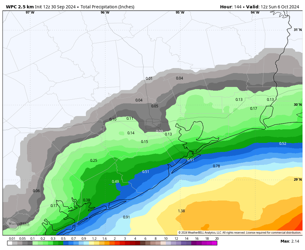
Our atmospheric pattern will become somewhat more upset by Friday, opening the door to a few passing disturbances. Effectively, this means that we’re likely to see daily rain chances on the order of 20 to 30 percent during the Friday, Saturday, and Sunday period. Chances will be low- to non-existent for areas inland of Interstate 10, and at the higher end along the coast.
Friday and Saturday are likely to see partly sunny skies, whereas Sunday looks to be mostly sunny at this point. High temperatures will probably range from the upper-80s to lower-90s. The risk to the forecast is that the atmospheric disturbances are a little more pronounced than expected, leading to more widespread rain. But at this point the most likely outcome is a fairly warm, mostly rain-free early October weekend that feels more like late summer than early fall.
Next week
There is a fairly decent signal in the global models for a decent front to arrive on Monday or Tuesday of next week, but since I’m not yet certain on its passage I don’t want to give anyone false hopes. Needless to say, next week’s weather in Houston will be determined by whether said front makes it all the way through Houston.
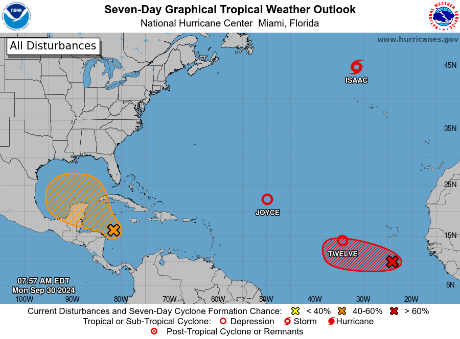
Tropics
We’ve had lots of questions about the tropical blob in forecast maps from the National Hurricane Center. Yes, we’re continuing to keep tabs on it. No, there still is not any indication that an organized tropical system is likely to directly impact the Texas coast over the next week or 10 days. For more information, check out our post from Sunday.

It’s been warm but Galveston is actually a few tenths of a degree below normal for the month and the nights are actually comfortable thanks to the drier air.
Hi Eric, thanks for all of your hard work, this site has been a Godsend during hurricane season. Maybe it’s too early for you to be able to answer, but we have a trip to Cancun planned for this weekend (Oct 4-8). I know timing wise the blob is going to probably start becoming something around the time we are supposed to land. Should we be worried about the impact on the Yucatan/consider canceling the trip? Thanks again for all y’all do!
It’s wild how many people ask the weather blog authors about their upcoming trips. You’re not going to get any insider information from the authors here before you get official information from the major weather monitoring agencies. They simply aren’t going to open themselves up to the risk of guiding your travel plans lol. Right now there will potentially be a storm in that area. What else do you want them to tell you that they haven’t already written up on the eyewall.
It was more about the timing of system, not the weather impact or how strong it will be. I literally wrote “maybe it’s too soon for you to answer.” I wasn’t looking for a definitive cancel or not cancel, nor seeking insider information, only the opinion of a professional who happens to excel at their job.
I have seen plenty of similar travel questions/comments on both sites that are sometimes answered by Eric and/or Matt. No reasonable person is going to hold them responsible for giving advice. But thanks for your constructive criticism 🙂
“No reasonable person is going to hold them responsible for giving advice. ”
Really, you think? In this litigious age?
If they can be sued for giving poor weather forecasts, then every meteorologist would be under constant threats of lawsuits because someone’s two year old’s birthday party got rained out or construction companies lost a concrete pour due to unexpected rains, or heaven forbid sudden, un-forecasted strong winds come up and push some roofer off of a roof. While it is true that you can get sued for literally anything… but wow I think you have to be realistic when someone is just asking for general advice.
Steve its probably best to keep tabs on weather reports this week to determine your future plans for your trip.
It’s getting droughtyish around here.
my lawn is certainly getting crunchy… my trees in pots need a lot of watering
I was wondering if anyone else was going to talk about the drought we’re in because SCW isn’t! It’s rained 3” in my neighborhood west of the Heights in six weeks and there’s almost no rain forecast for another 10 days. Yes, it might be slightly less humid but it’s still HOT and the ground is DRY.
“No, there still is not any indication that an organized tropical system is likely to directly impact the Texas coast over the next week or 10 days.”
Soooo 12 days from now… 😀 🙁
Exactly, lol
So dry. Dust clouds. Seriously. No rain since 9/12 and that was a light, light shower. It’s the one feature of warm weather here that is unlike that of the other gulf coast states. Rains buckets on occasion. Then long blue-sky dry periods. The only thing that grows well here are the live oaks.
Even live oaks will suffer if they are not watered.
So many homeowners seem not to understand the value of spending money on watering now and saving the trees and not having to spend much more money later to have them removed once they die.
Florida really got hammered by the last hurricane. Always worse in Florida than in Texas. Or so it seems.
Do you have any plans for a write up on La Nina? Specifically for how it could impact the Houston areas “winter” season? I’ve seen lots of info on traditional La Nina pointing to a drier, warmer winter for the south/ southeast in general but wondering what “dry” means for a place like Houston. Would love to see a section on that as we get closer to La Nina taking over.
Thank you for the Green Day reference.
This weather has been great for astronomy…keep it coming!
No forecast is going to make everyone 100% happy. But, while it does heat up quickly now with the drier air, I’ll gladly take it since it makes the nighttime lows dip.
As for those beating the “drought drums”, you’ll get your rain soon enough. Just use your faucet or hose right now. Humid is the norm around here so you’ll be fine.
According to the drought monitor, the drought drums are already beating. The entirety of Harris County is in the abnormally dry category already with no real rain chances on the horizon.
Thanks. I had not looked at that in a while. And that’s D0 as of 9/24. Maybe D1 on next update. Looks like some help from the Gulf this weekend tho. Humid is nice…
No rain since 26 July.