In brief: The first part of the weekend looks good, but we do expect Houston to see thunderstorms on Easter Sunday. Some of those storms could be strong, and that will be followed by more storm chances next week. Springtime is in force.
Today & Saturday
If you like hot weather, you’re in luck! There’s a pretty good chance we’ll hit or exceed 90 degrees today. It will also be quite breezy with south winds gusting up to 30 mph or so. Other than that, expect a mix of clouds and sun.
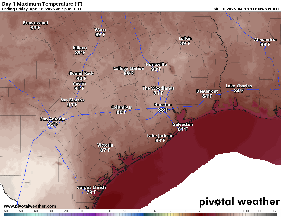
Saturday will be a bit cloudier. We’ll have a very mild morning, with lows probably not much below 75 degrees, close to a record for warmest April 19th morning. The day should again be breezy, mostly cloudy, and not quite as hot (but plenty humid). Highs should get into the mid or upper-80s. Shower chances look minimal, but I wouldn’t be shocked if the sky squeezed out a few raindrops here or there. Better shower chances will exist back toward Hill Country.
Easter Sunday
Sunday morning will be at least a little interesting. There should be a line or complex of thunderstorms near I-35 and the Austin area around sunrise. As those cross I-35 and move toward southeast Texas, they *should* begin to fall apart. Thus, the morning should be mostly cloudy with a couple showers here or there. As the boundary from that decaying line of storms hits Houston in the afternoon, we should see new thunderstorms blossom across the area. Some of these storms could be on the stronger side, and the SPC has us partially in a marginal (1/5) risk for severe weather on Sunday. This could yet change some between now and Sunday.
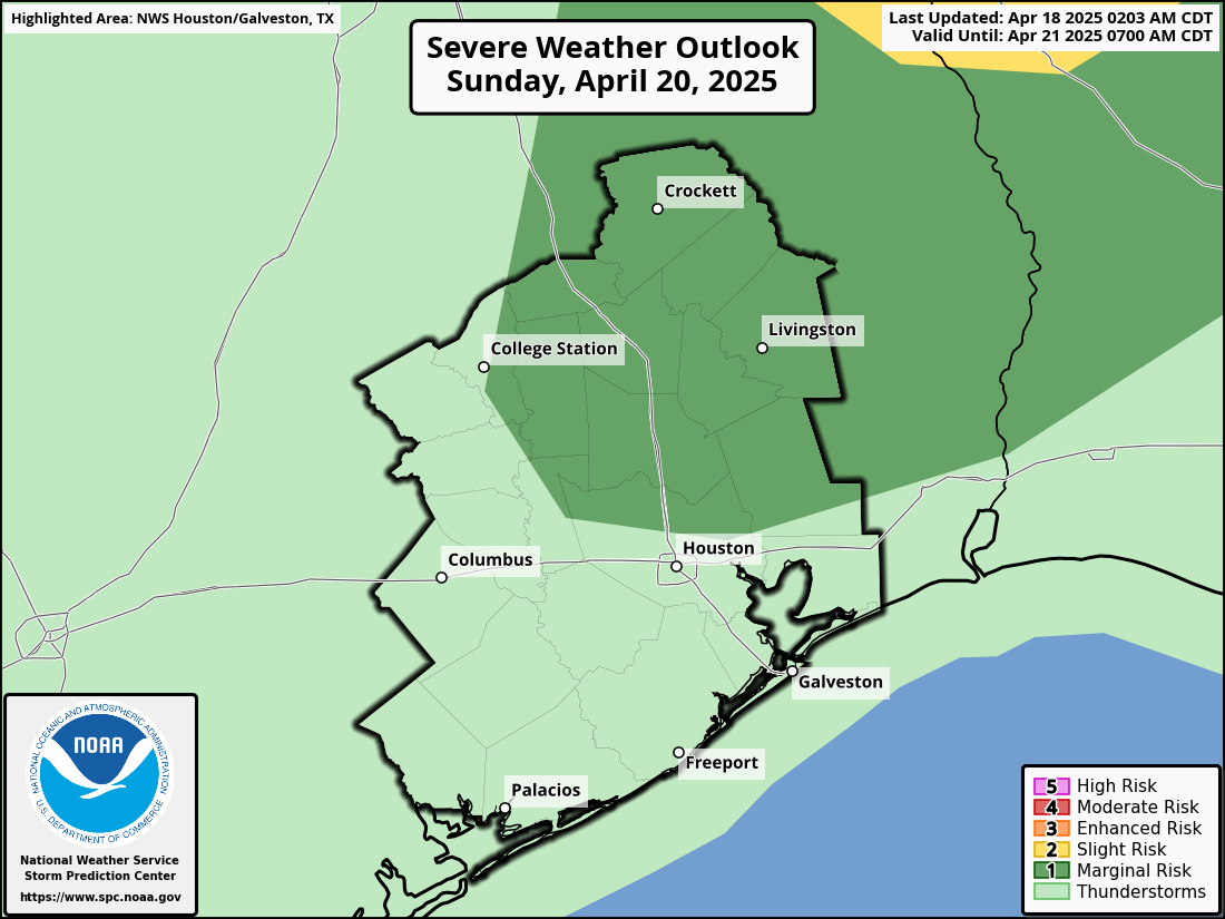
In addition to the potential for some strong to severe storms, atmospheric moisture levels will be more typical of mid-summer, so we could see some torrential downpours and localized street flooding crop up.
Eric and I will monitor this through tomorrow and have any updates for you on Sunday morning.
Next week
The cold front that will be responsible for the storms on Sunday is likely to stall out or wash out overhead. I would not be shocked to see the focus of thunderstorm activity on Monday to stay mostly east of Houston, closer to Lake Charles and Beaumont. But by Tuesday, that may swing back toward us, leading to scattered storms for Tuesday and possibly Wednesday or Thursday. This is the time of year where we can see afternoon storms blow up in portions of north or central Texas, organize into a cluster, and make their way toward us as complexes of storms called mesoscale convective systems (or MCS’s). I would not be at all shocked to see us have to wrangle that next week at least once. Bottom line: It looks unsettled.
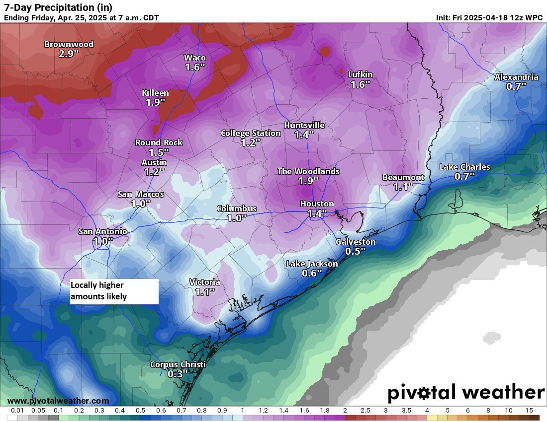
It’s a bit early to get into potential specifics, but it does appear that next week will be active. The clouds and shower chances will hold daytime temperatures lower next week (more like low 80s), with warm nighttimes in the upper-60s to low-70s.

Ty Matt ⚘
I’m a little nervous about next week. Is the threat of a derecho there or is it just gonna be a soggy weather pattern?
Yeah I’m not liking either
at all
I never say “no,” because unforeseen things do happen. However, this looks more like a very typical spring storm setup across Texas. Nothing about it looks overly foreboding. So I would rest easy for now.
Happy easter weekend everyone.
Somewhat related question: when do we (as in everyone sane in America) expect the cuts made to NOAA and programs that fund weather collection data to start impacting forecasts, if they haven’t already? Is there going to be a point in time where there’s an additional “uncertainty” factor to add into predictions and models?
Thinking of the way the derecho wrecked large parts of Houston last spring and wondering if the lack of predictability we saw in that event could become the norm. I imagine with the added bonus of a warmer Earth already making weather forecasting difficult, things are going to get very bad.
There are already differences. A NOAA meteorologist said they started immediately. Enormous data loss.
Matt said (in the Eyewall) that the loss of weather data will be more impactful on stronger events.
I interpreted that as the stronger the event, the more likely the inaccuracies in the forecast.
(Hurricane season will be an unfortunate test run of what a lack of radiosondes will do to a forecast, esp when it’s critical).
As far as weather forecasters go, I do not expect truth from anyone, except SCW.
There have already been a couple cases where a few of us in meteorology believe that the loss of upper air observations made a difference, negatively. We can’t entirely prove it out yet (this stuff takes time), but there is some reason to believe that we’ve seen some instances already. Granted, most people wouldn’t notice these things in most cases — but we do, and eventually something will happen where people do notice, it’s an inevitability on the current path. Now, if upper obs start again in full, this won’t be a continuing issue, so it can still be fixed.
Matt and Eric, is there an easy way to read what the Houston-Galveston NWS was writing a week ahead of the Memorial Day and Tax Day Floods? And what the WPC 7-day rain maps looked like a week before those events?
Possibly (??): google for:
WPC QPF Archive
Houston AFD (forecast discussions) should be archived here: https://mesonet.agron.iastate.edu/wx/afos/list.phtml (just change the office to HGX and the date to whatever you’d like, then tap “givemegiveme” (lol) and tap on AFDHGX for the various times.