In brief: A tropical storm is likely to form just off the Texas coast within a couple of days, and it could bring some rains and winds to Houston on Tuesday and Wednesday. How impactful the storm is will depend on how close to the Texas coast it gets. For now, we are leaning toward far enough offshore to avoid significant disruptions in Houston. But the forecast is not locked in.
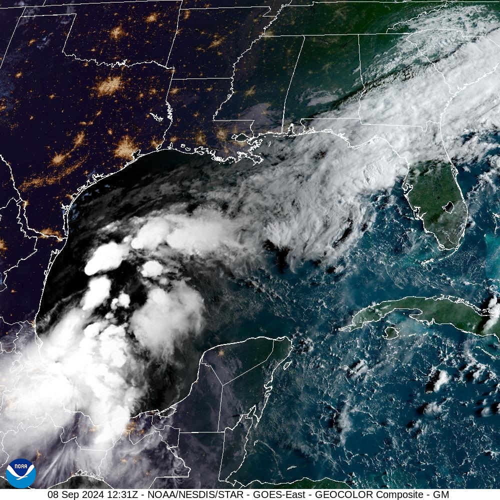
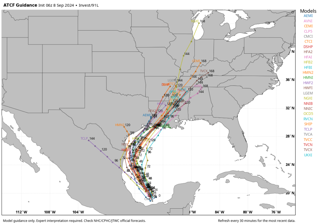
All of our available data continues to point toward the formation of a tropical storm in the western Gulf of Mexico within the next 48 hours or so. Our confidence is pretty high that by around the Tuesday afternoon to Tuesday night period this system will be positioned 50 to 150 miles offshore the Texas coast, about due east of the mouth of the Rio Grand River.
The question for Houston is, what happens after that?
Over the last several runs, we’ve seen better model agreement in those outcomes. So while I’m not ready to say this is a high-confidence forecast, I do feel as though it is fairly likely to occur. By Wednesday the storm will probably be moving more or less parallel to the Texas coast, to the north-northeast. Then by Wednesday evening or Thursday, the system—most likely a tropical storm, but it’s impossible to rule out strengthening into a hurricane—would make landfall somewhere in southwestern Louisiana.
This forecast can change, and indeed anyone who has followed tropical weather knows to expect the unexpected. Additionally, this area of low pressure that we’re talking about remains a fairy disorganized mass of showers and thunderstorms in the southern Gulf of Mexico as of Sunday morning. The accuracy of the models should increase as a center of circulation forms today and Monday. However, at this time all of our guidance is pointing to a scenario in which this tropical system gets fairly close to the Texas coast, but then remains offshore as it moves to the northeast.
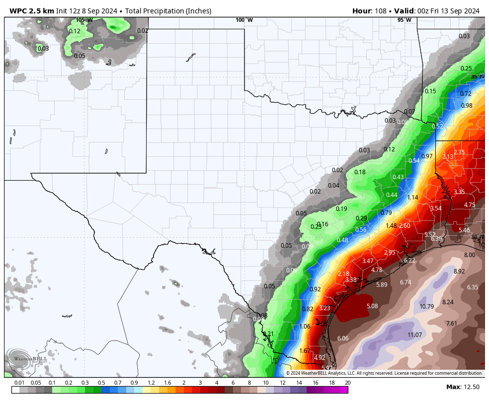
Ok, with those caveats aside, what happens in Houston under such a scenario? Basically the same areas that saw a lot of rain last week are going to see more rainfall. That is, coastal counties will be most at risk for heavy rainfall, with the possibility of picking up an additional 3 to 6 inches. This forecast remains highly dependent on how close the tropical system passes to Houston, of course. A storm closer to shore would nudge the heavy rainfall into all of the Houston metro area, and a storm a bit further offshore keeps the heavy rain away from even places such as Galveston Island.
As for winds and seas, with the storm offshore, the worst of these effects would be to the east of the center. Therefore, while winds and seas should increase along the upper Texas coast, with the current forecast they would not be anything extraordinary. We’re talking something like wind gusts of maybe 30 to 35 mph right along the coast, with lesser winds inland; and tides 2 to 3 feet higher than normal. Remember, both of these effects are very much tied to the track of the storm, so precise forecasts are impossible at this time.
In terms of timing, the most impactful days for Houston’s weather will probably be Tuesday and especially Wednesday.
The bottom line is that, right now, we don’t anticipate major impacts in the Houston area from this tropical system. That could, of course, change. If it does we’ll let you know as soon as our thinking changes. Expect another post later today, from Matt, on the latest forecast and a broader look at impacts for the Texas and Louisiana coasts.

Well, get ready for widespread power outages if it even so much as drizzles. I’m so over this grid and this climate. Just 2 more months and I’m out of here. No more heat and hurricanes for me, thanks. Back to the frozen wasteland I go.
I’ll miss your complaining posts.
LOL!
🤣
I feel like you said you just had two more months in Houston back in July.
Adam the troll is his real name at this point
Two months from now, he will still be saying the same thing.
Time here is a 2:1 deal. I’ve only been here 13 years, but it feels like 30.
Bye Felicia!!
chuckling
He’s certainly right about Centerpoint.
lol shut the heck up. Jesus these whiny ass transplants are such a miserable lot. It drizzled and rained all last week and the power grid was fine. You know damn well we don’t lose power here that often. Only during actual big storms which are also not that often. Two so far in a season predicted to be active is hardly a common occurrence. We didn’t have major storms in 2023 or 2022.
I am a transplant….from 27 years ago. And the ERCOT and Centerpointless grids are worthless. These two entities get away with MURDER! The makers of backup generators must have continual orgasmic dreams about the TX power situation. There are three types of utilities that should stay or should have stayed as regulated monopolies; Electricity, water, and natural gas. I would have added telephones, but nobody has a land line any longer that is not coming through a cable connection or a cellular connection. Deregulation just does NOT work. All we have are a ton of little companies selling us power that is generated by maybe four of the big players, mostly all at about the same price.
And to address the comment by JD, what about the 2021 massive outage during the massive cold snap in January (or was if February)? That most assuredly was not due to winds.
👍
No, it was caused by frozen windmills and gas-powered generators that froze.
Dave: 👍👍
You need a better frame of reference, JD. We never power issues like this in the 80s, 90s or even early 2000s.
The grid has been allowed to f a l l a p a r t.
Agreed, Tom. Underinvestment for decades, just like the roads, bridges, and water system. All in the name of keeping things cheap and taxes low.
Probably not. Power outages are caused by fallen trees and limbs on lines. As Eric says, the models show this storm going way offshore which means minimal impact on the Houston area.
The key word is “back” – and from a native son, speaking sympathetically, my best advice is that anyone contemplating “going back” should not prolong their agony, go back now to improve your mental health. Go back in droves – so it will make a difference.
Every time you post is 2 more months, at this point you’re just trolling fit reaction. Grow up.
I’m I agree. The power goes out if there is simply a breeze. The climate is the worst. I’m also planning on moving next year.
That’s hilarious! Agree about terrible Houston everything!
Thanks, Eric!
Can’t make it a full season without a Louisiana landfall huh? Those guys are like hurricane magnets…
That Lake Charles office tower damaged in wow 2020 has finally been imploded. https://apnews.com/article/implosion-building-louisiana-hurricane-08a5112f503614e3516fb764d9548cff
Scheduled to fly into IAH Tuesday Noon. Will the airport still be working?
I am a retired professional pilots. As long as winds don’t become excessive, more than about 50 knots, airplanes can land in any weather. There might be delays due to Air Traffic Control. The storm is supposed to affect Houston more on Wednesday
I am going out on a limb and say this will be a nothing burger for the Greater Houston area. Too many of these track further to the east than they are forecasted to do. We will be on the good side of a storm with lots of dry air in place.
crossing my fingers
And toes……🙏
I realize this won’t be the most popular comment here, but those of us in SW LA have gotten way more storms than Houston in recent years.
Selfishly hoping for a more west track so we don’t get slammed again. Lake Charles still hasn’t fully recovered from Laura.
Coming onto a Houston based weather page filled with people still anxious over Beryl and hoping a storm hits the city is a….judgement call, to be sure. And Laura was four years ago. If it hasn’t recovered over there, it’s not our fault.
Hey were you not called out on the eyewall site for trolling regarding yesterdays post?
Posting a ‘side-eye’ emoji is not the same as wishing despair and pain on others by hoping a potential hurricane goes west, but go ahead and go off.
Golden Nugget recovered quickly as that’s higher priority over citizens. ‘Mercian way
We have way more people here. Houston has gotten slammed pretty bad in the last 8 years with Harvey and other storms. You don’t need to be wishing it hits us. Maybe wish it fizzles out for everyone instead genius.
Harvey was a rain storm. It was a hurricane when it came ashore at Rockport but we had very little wind with it. We got some rain but not nearly as much as they got east of us.
It seems @semcgowanjr is completely out of touch with regards to past storms, and intensity, and impact to folks.
Quote: “We got some rain but not nearly as much as they got east of us.”
Geeez – a degrading and dementia-oriented statement.
We lived in Cypress at the time of Harvey. Over six foot of water dumped in our home and we lost everything. I know I’m repeating this because of another silly comment a day or so ago.
Harris County bought and razed our Cypress home, plus over 20 other homes in that well-established (late 60’s) neighborhood, which ISN’T “east of us”. Thousands of others suffered as bad and some even worse. And they were, also, not “east of us”. Been in the Houston area for almost 68 years, so have way more understanding.
Comes across as a politician does – for attention to self.
That is COMPLETE GARBAGE. Harvey slammed into Rockport as a Cat 4 & ripped up infrastructure. There are smaller towns like Refugio on the Bend that have become almost ghost-like since then bc they don’t have the resources to rebuild.
And Houston was flooded – a city full of bayous and drainage areas was overwhelmed. I saw fishes swimming in ditches bc they had been misplaced by rising water. That doesn’t occur w ‘some rain”.
Some people lost their homes and everything they had.
Get your facts straight.
You are correct and I don’t blame you for hoping it tracks west. However, the good news it that this one is not expected to be more than a tropical depression or low tropical storm. SW LA sees far more storms than Houston, which is more than 50 miles from the coast and rarely gets more than tropical storm – force winds.
I’m praying it miraculously weakens to nothing but a little rain for ALL
You are correct. Tropical systems nearly always track more to the east than originally thought. This has been true of hurricane I’ve experienced i the 25 + years I’ve lived in this area. It was true as recently as Beryl, which was expected to hit Corpus but drifted east and came ashore in Matagorda Bay. Prevailing winds over the Gulf (and most of the US) are southwest to northeast and that’s how storms track except in summer when winds are light and variable.
Glenn – Do not mock the weather gods. You should know that by now. Hunker down.
Don’t worry, Blackhawks. I’m burning the incense right now
Here we go.again!!!! Lets go to the store and buy all the water!!!
Point of interest: the drinking water in Houston is as fine as it ever is. There’s actually no need to go buy bottled water if you have some warning a storm is coming. Just fill up some jugs and containers from your tap.
Ewwwwwwwwww
That’s so cringe.
Please tell me you don’t do that, please tell me that’s a joke….
This may be one of the weirdest reactions I’ve ever seen. How is filling a container full of water disgusting to you? What exactly do you think bottled water is besides water in a container?
I have a feeling you’re not going to do so well if there’s ever a prolonged emergency.
mostly clear skies for today (and tomorrow as well?) in Houston area means excellent solar production. Coupled with cool(er) morning (ie., less AC usage) resulting in excess solar energy for charging my batteries.
Need more days like today!
The Texans game will determine it. If they win we dodge a bullet, they lose we get hit head on and Down Goes Houston with a Beryl 2.0 knockout punch with power outages and chaos. The game will be deciding factor.
Looks like we’re good then…barely lol! What a game!!
Ah, yes – the same models that took Beryl into Brownsville. They’ve been worthless this year.
CenterPoint just sent a notification
“ We continue to monitor and prepare for a potential tropical system in the Gulf which may impact the Greater Houston area over the next few days. We encourage you to prepare an emergency plan. Customers who depend on electricity for life-sustaining equipment are encouraged to make alternate arrangements for on-site backup capabilities or other alternatives in the event of loss of electric service.”
Great – they’re absolving themselves of responsibility in advance of their certain failures.
What a bunch of SLIMEBALLS.
Corporate CYA…