In brief: It’s a fantastic day in Houston, with amazing weather—this evening will feel great—and an impressive season opening win by the Texans. Unfortunately, we need to keep one eye upon the Gulf of Mexico, where there is tropical activity. Here’s the latest, via The Eyewall, on what to expect in Texas and Louisiana from the impending storm.
We are continuing to watch Invest 91L, a tropical disturbance in the southern Gulf of Mexico that is likely to be upgraded to a potential tropical cyclone later today or tonight by the National Hurricane Center. This will probably mean the issuance of tropical storm watches on the Texas and Mexico coasts.
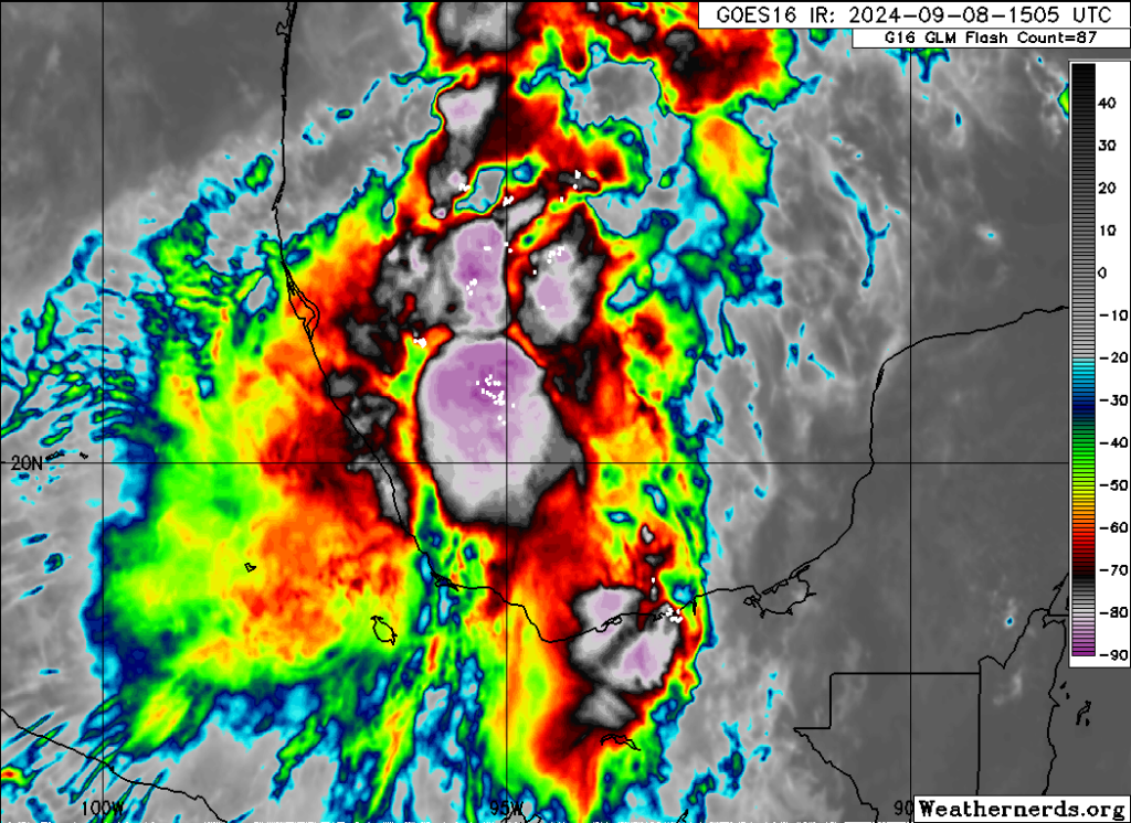
The disturbance continues to produce ample thunderstorms in the Bay of Campeche, but it remains a day or so away from actually organizing into a formal tropical entity. Look for things to start trying to get in gear later tomorrow.
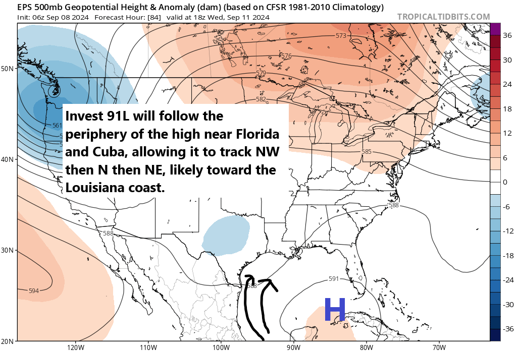
From a forecast perspective, this setup is certainly not without nuance, but it does make the track forecast a little more simple. Initially, 91L will track northwest in the Bay of Campeche. From there, as it organizes, it will begin to turn toward the north. Eventually, it should turn northeast, which, depending on where it forms, puts it on a track likely between Galveston and central Louisiana. Again, there is nuance here in that a weaker outcome would lean left, closer to the Galveston-High Island corridor, whereas a stronger outcome would track a bit closer to Vermilion Bay in Louisiana. But for the most part, I think the track forecast is relatively well understood at a high level today.
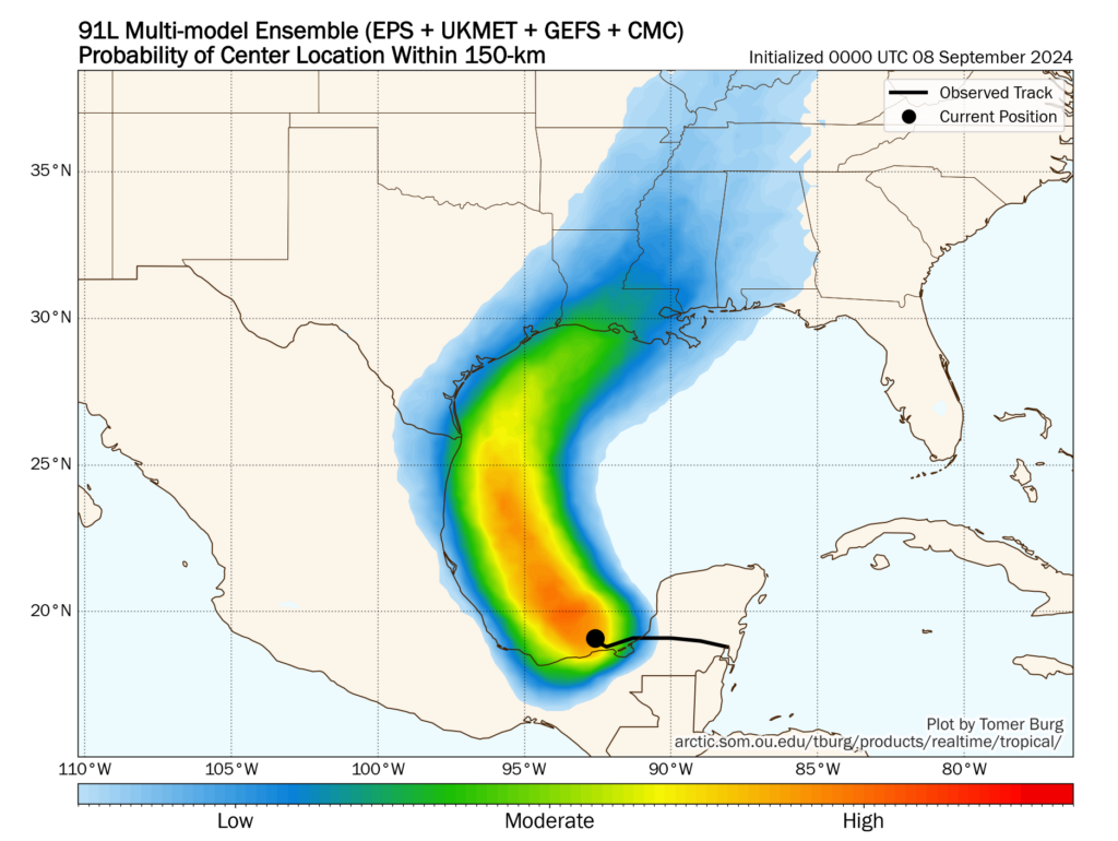
Trends in the last 24 hours have been toward a slightly stronger storm closer to central Louisiana. But there remains a relatively wide berth of possible outcomes. So don’t write it off in Galveston yet, but it is likely that if it hit Galveston directly, it would be a weaker storm.
Intensity
So let’s talk about intensity. Operational modeling has come around to the idea of a more well developed, stronger storm now. Earlier this morning, most tropical modeling was spread between high end tropical storm and low end tropical storm intensity. This afternoon’s runs have tended to bump this up a little, ranging from weak tropical storm to hurricane intensity. SHIPS guidance, which forecasts the odds of rapid intensification suggests about a 6 to 8 times greater than normal potential of this rapidly intensifying in the next 72 hours. Wind shear looks low, and while sea-surface temperatures are not ballistically warm in the western Gulf, they are at or above normal away from the immediate coastline and more than supportive of intensification. It appears the environment will be favorable for intensification.
Based on all this, we are likely heading for at least a moderate to strong tropical storm and a reasonable chance at a hurricane assuming this tracks as shown above toward Louisiana.
Impacts
Obviously, we’re going to be concerned with tropical storm or hurricane impacts near and especially east of where this comes ashore, which I won’t try to pinpoint exactly right now, but they’re primarily on the Louisiana coast at this time. We will cover that in more detail tomorrow as more becomes known with respect to track and intensity. We should expect waves of 10 to 20 feet offshore with this as it comes north. Gusty winds will occur on the coast between Matagorda Bay and Sabine Pass in Texas, possibly up to tropical storm intensity (35 to 45 mph). Inland locations like Houston should see much less of that. And again, Louisiana will likely see stronger winds. If the storm comes in at Galveston or High Island, there will be stronger winds in the Beaumont-Port Arthur area.
One of the bigger impacts with this storm will likely be rainfall. Somewhere will likely see 10 to 15 inches of rain from this storm with widespread amounts a little under this elsewhere. For Texas, with a track more to the east, this has generally lowered rain totals there. However, that has led to higher totals in parts of Louisiana. The map below shows the European operational model’s forecast of rainfall. Normally, I don’t care to show operational model guidance rain maps, but I think this is a decent representation of risk. The highest totals will be along track and to the east, but the entire coast, even west of the landfall point should see at least some heavy rainfall.
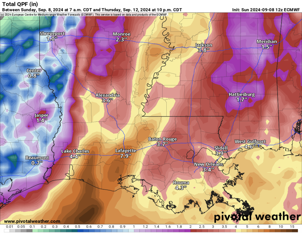
I expect flash flooding to be a concern in Louisiana, which has seen a good bit of rain lately, as well as in southern Mississippi and Alabama. Coastal Texas will be dependent on exact track, but flooding risk doesn’t look overly concerning right now. Still, check in on this again to see if anything’s changed.
Storm surge will also be an issue, but we will await guidance from the National Hurricane Center on that before speculating. And as always, tropical systems can and do produce isolated tornadoes.
At this point, interests on the Texas and Louisiana coasts should continue paying close attention to the forecast updates on Invest 91L or the potential tropical cyclone. The biggest concerns right now are for Louisiana, but continued monitoring is advised in Texas too.
Note: Space City Weather will have a brief update this evening by or before 10 pm CT with the latest.

Why are we calling these Cyclones? Don’t we have our own American name, Hurricane? Is this mandated by the UN or something?
Hi @Pthirima …after a search and quote from NOAA:
“Once a tropical cyclone reaches maximum sustained winds of 74 miles per hour or higher, it is then classified as a hurricane, typhoon, or tropical cyclone, depending upon where the storm originates in the world. In the North Atlantic, central North Pacific, and eastern North Pacific, the term hurricane is used.”
That’s because that is the generic scientific term to classify these storms? Here since you don’t know how to use google and just assume its all political.
https://oceanservice.noaa.gov/facts/cyclone.html#:~:text=Once%20a%20tropical%20cyclone%20reaches,the%20term%20hurricane%20is%20used.
“hurricane” comes from the Carribbean Taino native people’s word: “hurakan”
I prefer the name “freedom storm” myself.
Yes! ‘merica!
Can saying Merica die already please 🙄
A cyclone is a rotating air mass. The term is not related to the region in which it forms.
Thank you for the update! When do you think this will land and how fast will it move inland and out of Texas/Louisiana?
Went on the daily walk around 7am – nice cool weather with breezes. We actually walked twice the normal distance, and will add more steps near sundown. It’ll be nice to have another morning of coolness – hope it continues.
Also feel a bit comfortable now that 91L is predicted to approach land east of Houston area. Fingers crossed it continues as such – even us folks up Magnolia way have had damaging consequences with past storms.
Here we go again…. models get more intense and move closer to Houston… get ready Katy….
The NHC has now labeled 91L “Potential Tropical Cyclone Six”.
And when you click on its “X” on the 7 Day Gulf map, a new page is displayed with the ten typical graphs they show for cyclones and hurricanes.
The Fox 24 Hour Weather channel (26.3 and on the web) have increased their discussions about it.
Nothing burger
For us…
Something a little more for Louisiana
Now a model has a cat 2 heading straight for us..
And tomorrows models could have something different.
Where did u see that?
Almost every model has it hitting Louisiana. Not sure where you’re seeing this.
where are you seeing that model?
Called it lol.