In brief: Development of some sort of tropical system is becoming increasingly likely in the western Gulf of Mexico next week. Generally, there are two potential outcomes: Either a better organized system that tracks offshore toward Louisiana, or a lesser organized system that tracks offshore but closer to the Texas coast. In this post, also published on The Eyewall, we go deeper on what could happen and its implications for the greater Houston region.
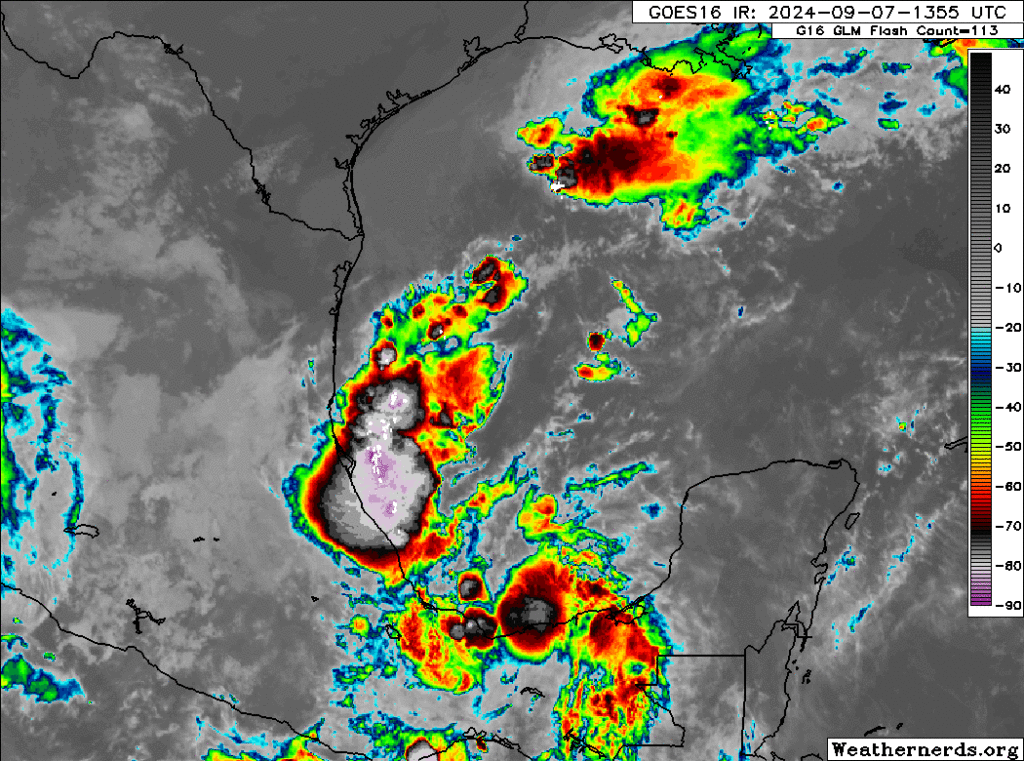
The state of play as of early afternoon on Saturday is that we have a fading system in the northern Gulf of Mexico, which was responsible for much of our rainfall this past week; and we also have Invest 91L with thunderstorm activity in the southern Gulf, but no real organization. Our focus should now turn toward 91L, in the southern Gulf.
At some point heading into later tomorrow, Invest 91L will probably halt its southward progress, slow down and begin to make a turn back northward later on Monday. From here, we’re beginning to see some model consensus increasing around this becoming at least a tropical storm by Tuesday or Wednesday. Development odds from the National Hurricane Center have increased to 70 percent as of this afternoon.
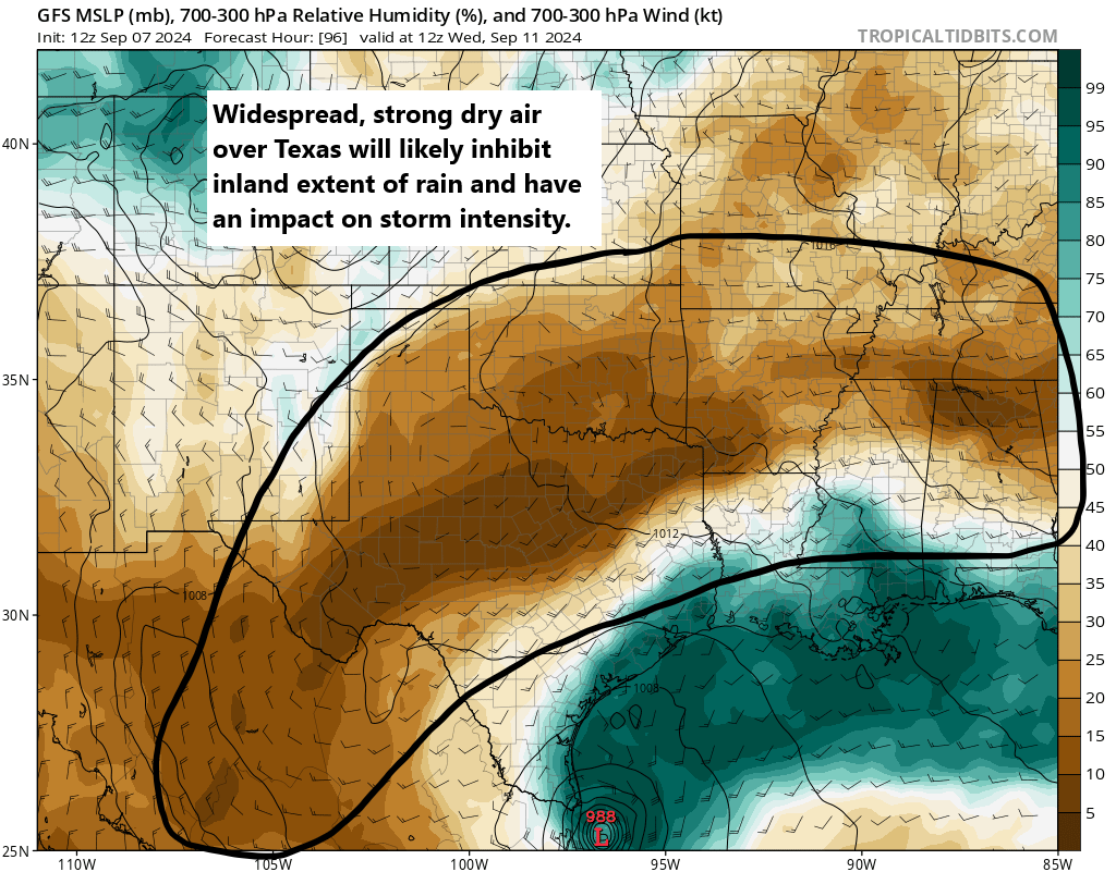
As 91L comes north, it will enter a tricky environment from a forecast point of view. On the one hand, you will likely have low shear and warm Gulf waters to help it along. On the other hand, there is likely to be a lot of dry air over Texas thanks to this weekend’s early fall cold front. That dry air works against tropical development. We’ve seen dry air in Texas take its toll on tropical systems before, so that’s one reason to be cautious about some of the more bullish models.
Whatever the case, slow, gradual development is likely late Monday and Tuesday as this comes north about 100 to 200 miles off the coast of Mexico. Modeling is actually in very good agreement on all this through Tuesday morning. From that point, the models diverge. The European model, which I might argue would have a better handle on more of the nuance at play here, tends to develop this slowly. The GFS, ICON, and Euro AI (AIFS) modeling shows a slightly faster development path for 91L on Tuesday into Wednesday.
This poses an interesting forecast challenge. The upper pattern on Tuesday night/Wednesday morning will support steering currents around the periphery of high pressure off the west coast of Florida. This should allow for a north and northeast track in the Gulf. A stronger storm would probably be more apt to take that northeastward movement, where as a weaker storm may come more due north. We see this as both the ICON and AIFS show a faster, stronger storm farther out in the Gulf headed toward Louisiana, whereas the European model keeps it weaker and close to the mouth of the Rio Grande River.
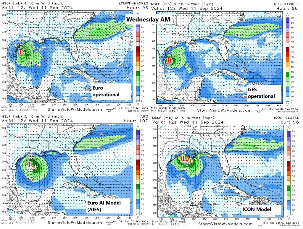
The GFS eventually caves and strengthens it, allowing the system to follow the AIFS/ICON group toward Louisiana, whereas the European model just brings it into Texas as a depression or low-end tropical storm.
Obviously, this gives us a forecast challenge, but I think we’re in two very distinct camps right now.
- Camp 1: A strong tropical storm or hurricane that tracks off the Texas coast toward Louisiana arriving Wednesday-ish.
- Camp 2: A depression or loosely organized tropical storm with a lot of rain that impacts Texas, especially at the coast Tuesday through Thursday, coming ashore between Galveston and Cameron, LA.
I am not a betting man, but I would probably say the odds right now are 70/30 in favor of camp 2, but that 30 percent is a weighty one given that the system could be a hurricane in that scenario. Normally, I’d discount the ICON model, but given its performance this season and the consistency it has had with track and intensity here, I think there’s merit to considering it with this particular system.
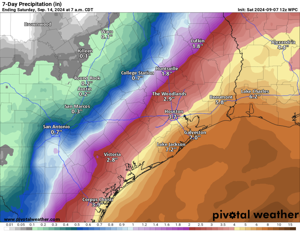
So what do you do? You check back in again tomorrow for more. If you’re in Louisiana, it’s probably a good idea to make sure you have your hurricane kits up to date and know what you’ll do in the lesser chance this comes your way as a stronger storm. In Texas, I think Houston and Corpus Christi are fine. However, I think folks from Matagorda Bay through Sabine Pass along the coast and bays should probably be aware of both a rainfall flooding risk and a tidal flooding risk that may develop from this. More to come.
Note
We’ll continue to monitor this storm closely. If the forecast materially changes, and we are likely to see more directly threats in terms of wind and surge in the Houston area, Space City Weather will publish an update early on Sunday morning. If the forecast remains more or less the same, look for an update later in the day.

Thanks for the information.
I read it all, but I’m curious if anyone can give practical input currently for greater Houston area. Worst case currently sounds like just heavy rain.
Right now just rain and wind the closer it is to the coast. Of course the models can change so stay tuned to weather reports through the weekend
You can’t make predictions like this until a storm has actually developed and is on an established track.
A worse-case scenario is always sharknados.
Thank you for the update. I certainly hope it’s not Beryl 2.0 or worse 😢
Folks need to understand something about Beryl – it wasn’t that bad. It was barely a Cat I hurricane with 80 MPH winds at landfall and around 75 south/southwest of Houston where I live and down to tropical storm by the time it reached the vicinity of Katy. We had sustained winds for about four hours that blew over trees but that’s all it really did. (We had a large pecan in our yard that blew in from next door and a white oak in our yard that blew over but the only damage was to our fences.) Beryl was nothing like Ike, which was a Cat 2 just east of Galveston.
While I sit here in an Airbnb because it’s going to take another three months to finish putting my house back together after a tree fell on it. Not insignificant. I’m in clear lake.
@semcgowanjr … and Ike was nothing like Harvey. We lost our Cypress home – over six foot of water in it (+ we lost everything in it). 20+ homes in that neighborhood (established in late 60’s) were purchased by Harris County and razed.
Brother-in-law and his wife are waiting to move back into their Beryl-damaged home. We were out of power for five days, many had it worse. Your experience doesn’t speak for others 👍
I’ve lived in Surfside since 1966 and have been through many hurricanes. There is no way on Gods green earth Beryl was a Cat 1. We had 127mph sustained winds here for hours.
NWS highest sustained winds officially recorded for Beryl were 56 knots (64 mph)
Got up around 7am and went for the 30 minute morning walk. It was absolutely nice out! Will finish out daily steps this evening.
Also looking forward to the daily walks over the next two cooler days in Magnolia!!
I live about halfway between Houston and Galveston. What are the chances of heavy rain.
It’ll become a weak Tropical storm and ride the Texas coast up north. As it moves north, it will straddle the high pressure ridge and warm moist gulf waters, causing stage 2-3 flooding, mainly affecting coastal areas along the way.
The storm may stall out as it heads further north, allowing further development to a stronger Tropical storm but not likely a Cat 1. If it does become a Hurricane, it will be named Francine, and happen right before it makes landfall around the Texas/Louisiana border.
How it will affect us: This isn’t going to bring a lot of wind, but will mostly cause a lot of rain bands to train towards the Texas coast. As this is a slow moving system, that rain may quickly accumulate over time causing street flooding and bayous/creeks to reach capacity.
Be prepared for some power outages and potential for flooding around low lying areas and along the coast.
Thank you. If you had to guess, what part of Texas do you see getting heaviest rainfall, and by “North” do you mean through Texas?
Once the high pressure starts to weaken it’ll head inland. Probably around late Tuesday, between Beaumont and Louisiana, I’d say. I’m guess Houston will get like 35mph with some gusts in there. Enough to see how well Centerpoints duct tape holds up.
It feels like a pattern we all know all too well at this point.
But hey, I could be wrong… 🙂
Centerpoints duct tape…. 😂
Love it!
That person could have used AI for their comment and you accepted it as accurate?
Maybe it’s my imagination, but forecasting these tropical disturbances has been frustratingly difficult, chaotic and slow this year…Are the experts using a different format/protocol that isn’t doing well with this year’s tropical systems? If a tropical system was potentially to hit TX/LA as a low end hurricane, or Galveston as a sloppy tropical storm on Weds, I would hope by late tomorrow we would have the official info we need to start making decisions ..Info such as a cone containing the highest probable possibilities for landfall, projected times when /where wind and tidal surges hit, ect..
Not really. Too much dry air over Texas inland at this point.
Galveston here, what are we thinking as far as tides coastal flooding? More like Alberto or Beryl?
Too early to say, but I would definitely lean toward Alberto over Beryl in terms of impacts.
Isn’t there any hope the storm could just move inland toward the northwest and spread the rain out all over the east half of Texas rather than again all being right along the coast?
Aside from this year, I can’t recall bad hurricane seasons for the past five years. The humidity is terrible, but then the worst of it is gone after a couple months. I guess it’s personal taste, but would prefer less the other extreme….5 month long winters with gray skies.
Weather anxiety is a real thing, especially here. I encourage you to get help from a therapist. You don’t have to suffer like this.
Oh, goody…….another storm to deal with!
I haven’t finished Beryl repairs yet – maybe a good thing.
I’m in the same situation.
One big question. Will millions lose power?
Nah, only half a million or so………..
We’re supposed to leave the Beaumont area Wednesday night and head to Florida. Will that still be possible or too unsafe of a drive to risk?
Honestly, too early to say, only advice would be to keep an eye on updates over the next couple of days, by which time thee should be a clearer picture of where the system will be headed and its forecast strength.