In brief: Houston begins a slow transition back to a wetter weather pattern today, with higher rain chances tomorrow and Friday. No severe weather is expected at this time, but we cannot completely rule it out. It will remain fairly hot and humid, but “less hot” weather and even better rain chances may arrive early next week.
Hot weather will continue today, but shower chances begin to increase, and those chances will stay with us into next week. As we try to get back to a sense of normalcy after Hurricane Beryl, Eric and I just want to highlight and thank our partners at Reliant for their continued support of our site, as well as the community. Reliant and NRG just announced a $2 million contribution for near-term and longer-term Hurricane Beryl relief and assistance, including charitable contributions, customer assistance, and more. We thank them for that and their continued support and partnership with Space City Weather!
Today
Conditions have been fairly dormant in the rain department the last couple days. That will begin to change today. We already have some showers offshore this morning, as well as near the coast in Galveston and Chambers Counties. Look for additional scattered showers and storms to pop up with daytime heating today. It will still be plenty hot and humid, so expect highs in the mid-90s.
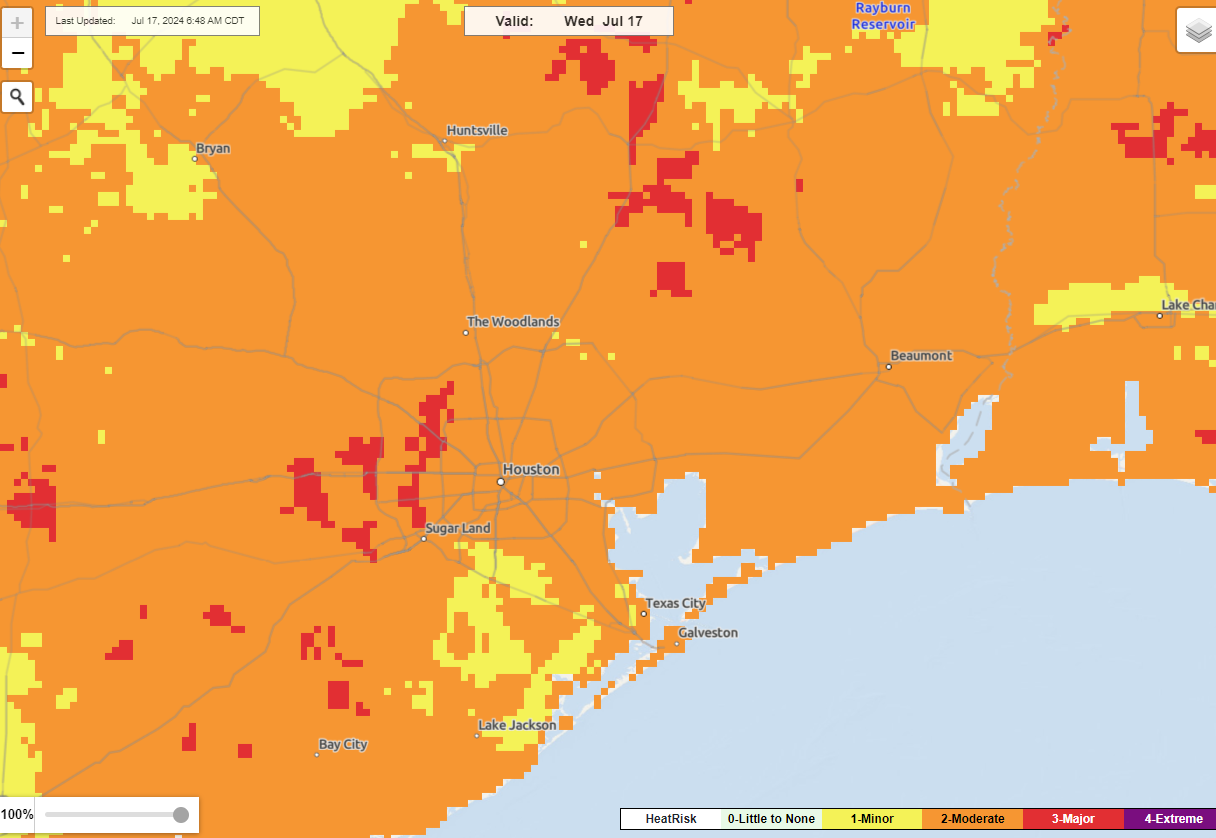
The added moisture will actually make today feel more uncomfortable than recent days as well. We still have about 50,000 customers without power in the area, so it will be another difficult day for those folks. We would strongly encourage continuing to check on those without power and ensure they have a cool place to go. The combination of heat and humidity will probably make today feel the worst that it has since Beryl.
Thursday and Friday
Both days will carry a pretty healthy chance of showers and thunderstorms. Storms will drop in from the north tomorrow afternoon and evening. Additional scattered storms will be with us Friday. While we are not currently highlighted in any severe weather risks for tomorrow or Friday these types of north to south moving storms can occasionally deliver a rogue severe storm or two. As I mused in the comments to someone yesterday, my five year old and I look at radar each evening (his doing, not mine!), and I’m always struck by how many random storms in the South can become severe in summertime. My point being: We aren’t highlighting severe weather risk the next few days, but it’s entirely possible we see something isolated stick out from the overall mess of showers and storms.
Highs will be in the mid-90s ahead of Thursday’s storms and near 90 on Friday with lows in the 70s.
Weekend
Both days will feature sun and clouds. We’ll probably see morning showers or storms near the coast spreading inland each late morning or afternoon. Not everyone will see rain, but many of us will, though hopefully it doesn’t totally ruin outdoor plans. Highs will be near 90 with lows in the 70s.
Monday and Tuesday
Rain chances increase again here as a more vigorous upper level system moves closer. This should lead to numerous to widespread showers and thunderstorms Monday and/or Tuesday with highs in the 80s.
Lows will remain in the 70s, as a high humidity air mass remains in control despite the cooler daytimes.
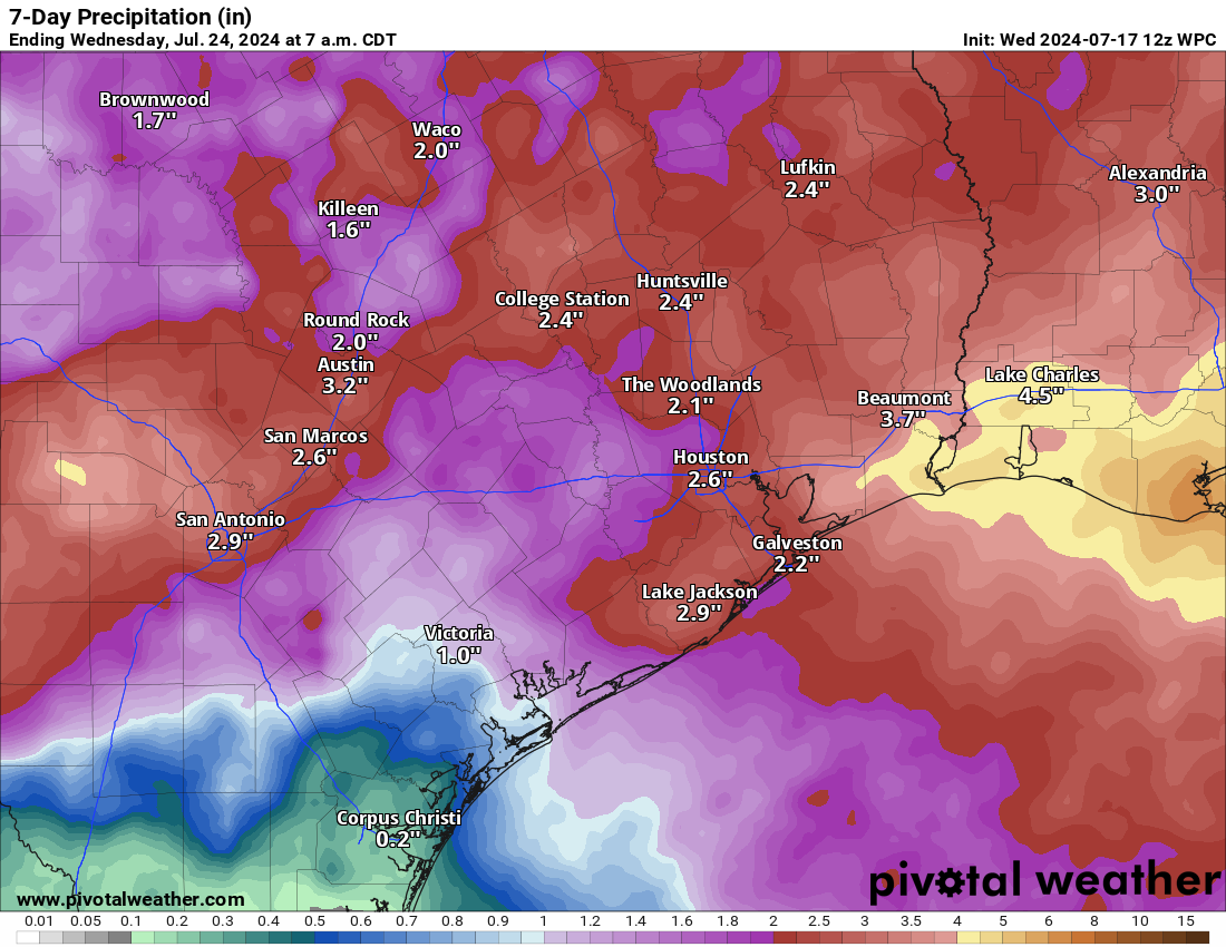
Rain chances should slowly settle down and temps slowly increase again by next weekend. All told, we’re probably looking at a widespread 1 to 3 inches of rainfall through next week with higher totals near the coast and lesser totals west and southwest of Houston.

Highs in the 80s, humidity or not, is still highs in the 80s. For late July, needless to say, I’ll take it!!
What are the chances of rains in the South West region, specifically for the Sugar Land area today? We have outdoor plans for the evening from about 5 to 10 pm.
Yes. My annual poodle prestige party is tonight. I’m concerned about my outdoor butter sculptures. They’ll be in an air conditioned tent, but I need the humidity in a certain range. Beading will ruin the effect. Hope it stays good.
Finally, I can cross poodle prestige and butter sculptures off my space city weather comment bingo Card
Say what???
After having no power for a week I don’t think I can stomach severe weather.
I find it interesting how expectations change.
After Hurricane Ike in 2008, we were 15 days without power at our house, but I do not remember near as much wailing and complaining.
I also well remember living in Texas when there was no air conditioning. The 1950s were especially hot and dry but we survived.
My request would be for the city and county to get busy with spraying for mosquitos.
Considering that CenterPoint has worked around the clock to restore service to over 2,000,000 customers, it would not seem to be too much to expect government to have a few trucks out spraying for the millions of mosquitos that have descended on us.
Ike and Beryl aren’t comparable in intensity – power outages with the former were to be expected, outages with the latter point toward an infrastructural problem.
I have been in Houston since 1958 so have seen a lot of hurricanes.
Beryl was the strangest storm that I have seen. Its ferocity and the damage it created do not match with it being a Cat One hurricane.
I have never seen so many uprooted trees and solid brick walls blown over.
I am frankly amazed that power has been restored as quickly as it has.
Some have said it was due to already weak trees from the derecho and saturated ground. Just a thought
What made Beryl so unusual is the fact that it maintained it’s strength so far inland. It stayed a cat 1 until it reached Harris County I believe. Usually Hurricanes drop of strength pretty quickly once they make landfall. I think the reason so many trees fell is a couple of reasons. We had alot if rain from Beryl. Most areas saw between 6 to 8 inches. This made the soil very wet and soft which makes it easier to uproot trees. Our trees have also been weakened from the extreme weather events we’ve had these past few years. We’ve gone from brutal freezes straight to brutal heatwaves and droughts. I am sure but not certain that this damages the root system in trees and makes them more susceptible to diseases which also makes it easier for them to fall over in strong winds.
As far as the winds go, Beryl was just a Cat 1 based off the wind speeds when it made landfall in Texas. The strongest wind gust recorded in our region was 92 mph in Sargent. That is still less than the minimum “sustained” winds of a Cat 2 at 96 mph. Wind gusts can get up to over 110 mph at the center even in a weak cat 2. We are very very lucky Beryl didn’t strengthen to a Cat 2 or god forbid a 3. There would have been much more widespread structural damage across our region and many more trees would have been knocked over. Many homes would have major roof damage and small trailers would be completely destroyed. Power outages would be the least of our worries if Beryl had blew up into a 2 or 3. The worst damage would obviously occur along the immediate coast but even Houston would of seen much worse damage overall. At the end of the day Hurricanes are nothing to play with regardless of ranking. We experienced the worst that just a Cat 1 has to offer.
Two things to make note of are that Hurricane Ike occurred in September and was followed by a time of cooler dryer air. The homes most people live today are constructed to inhabit with central air conditioning. Most homes people were living in prior to widespread air conditioning were constructed with cross ventilation.
The house I was living in when Carla hit in 1961 did not have air conditioning and definitely was not built for cross ventilation. For those who remember them, our house did have an attic fan.
Yes, thankfully, it was September when Ike hit. I was 72 years old in 2008 and I well remember spending 15 days without power and some of those days were quite warm.
Anyone who chooses to live in Houston and other areas that are subject to hurricane events needs to be prepared for power outages. I wish our house had a generator but, unfortunately, it does not.
I have had recent doctor appointments in the medical center so have had to drive across large parts of Houston and I, in my 66 years as a Houston resident, have never seen so much damage. The number of uprooted trees is, I think, un-precedented.
As previously stated, I marvel at how quickly CenterPoint has been able to restore power to most of the area in less than ten days. In my opinion, it was a Herculean task.
CenterPoint CEO Jason Wells sat in an armchair under a thermostat reading 70°, relaxed with his legs crossed, skewing facts and making inappropriate statistical comparisons to other storms and spinning CenterPoint’s lack of action as progress. CP did not deploy their crews appropriately ahead of time.
This is deadly in this heat. Wells cited a ’48 hour restoration’ withOUT counting the assessment time, which took days. This is a shameful and pitiful attempt to cover himself with words to deflect from what has actually happened. He is “proud of the progress” CenterPoint made.
The only ‘marveling’ going on should be at his Stygian lies.
Exactly. What’s wrong with you snowflakes? I had to eat lard on my biscuits and walk two miles in the snow each way with broken shoes to get to our one-room schoolhouse. I don’t understand these wailing whiners! Heat illness is in your head. Toughen up!
How bout them skeeters! There’s the real problem!
pounds fist on armrest
I have thought about this a lot the past 9 days. A lot of it has to do with social media influence, and how everyone has a voice now. It really has changed the way everything works for better or worse. In situations like this is for the worse, in my opinion. Not to dismiss infrastructure issues at all, just my thoughts on the complaining. I was out of power for 11 days with Ike.
I remember years ago the city had workers spraying for mosquitoes but it was due to west nile virus deaths climbing at the time
I remember Ike, granted, I was in my older youth, and all I remember is that, while the days were hot and full of repairing the damage, the nights were at least tolerable to sleep in, almost downright pleasant. Parents had a post-hurricane party and lit the tiki torches and BBQ and we all made it through and had a good time.
Beryl, on the other hand, had overnight LOWS in the 80s just a few days afterward the storm, and highs approaching mid-90s during the day… but I can’t provide too much more than that since I was dealing with the flu during the whole storm which probably shifted my perception too much to be useful. Still, the raw temps don’t lie and it was pretty hot, even through the nights.
We had a cool front blow in right after Ike which dropped nights in the low 60 for several nights in a row. It was mid September which is not out of the ordinary after September hurricanes. Hurricanes in July typically leave behind lots of heat and terrible humidity like we have seen.
Your 5 year old? It seemed like yesterday he was born!! Wow, how time flies!
No one sold that aspect of parenthood to me enough. It really does.
Just before Beryl, I took a tip from Dwight and bookmarked the Windy.com site. I’ve been looking at it every morning since and I’m struck by the variation in the short term forecast, depending on which model is used. For example, today’s high ranges from 87 on the ECMWF to 99 on the GFS. The forecasting intervals are three hours and that might explain some of the difference but …12 degrees F?
Am I missing something, or can you provide a little clarification?
Welcome to the world of meteorology. Each model is different and has various biases and quirks, and that’s why Eric and I are here: To try to sift through that so you don’t have to! But in all seriousness, there are occasionally massive differences. Some of that has to do with model biases (for example, the GFS has a notorious hot bias in urban areas). Some of that has to do with how rain chances are modeled. And on and on. It can get unruly. But we know not to trust raw GFS output in summer, and that it tends to push cold fronts through too quick in winter. Among other biases. By the way, with a high of 94 today, the winner was (Euro + GFS)/2. 🙂
No two Hurricanes are the same.
Ike was a huge but weakening Cat 2 on landfall with the worst quadrant of winds coming in east of Houston/Galveston in High Island.
Beryl was a smaller but rapidly strengthening Cat 1 on landfall with the worst quadrant of winds coming pretty much directly over Houston.
We will never know but I suspect Houston would have suffered a much worse fate during Ike If it came in where Beryl did and followed a similar track.
It’s amazing that Hurricane seems to have a very different effect on Houston based on a mere 20 miles or so of where the center and path is located during landfall. Forward speed, amount of rainfall, number of tornadoes spawned, and wind gusts generated are all factors. Harvey was the tragic oddball as far as tragic effects…floodwaters with very little wind problems. The others were combinations of severe wind and severe rainfall. Carla, Alicia, Ike, Harvey are all Hurricane names that effected this region of Texas and are now retired by the WMS. My guess is that the name Beryl will join this infamous list and be retired as well.
I forgot, they also retired Tropical Storm Allison in 2000. Another crazy flood storm.
But yes, it was the first tropical storm on record to be retired!
Oops this was meant to be a reply, 2001.