In brief: There have been few changes to the overall forecast today, with higher resolution modeling now coming into range on this storm and essentially validating most of what we’ve seen to this point. A legitimate, rare winter storm, with primarily snow and sleet is likely to impact most of the Houston area tomorrow night and Tuesday, causing significant travel disruption through at least Wednesday morning.
What’s new?
A few minor notes this afternoon, none of which are significant changes in thinking from this morning.
First off, the NWS has upgraded us to a Winter Storm Warning and increased their snow total forecasts for the Houston area.

They have also increased the “realistic worst case scenario” snow forecast.
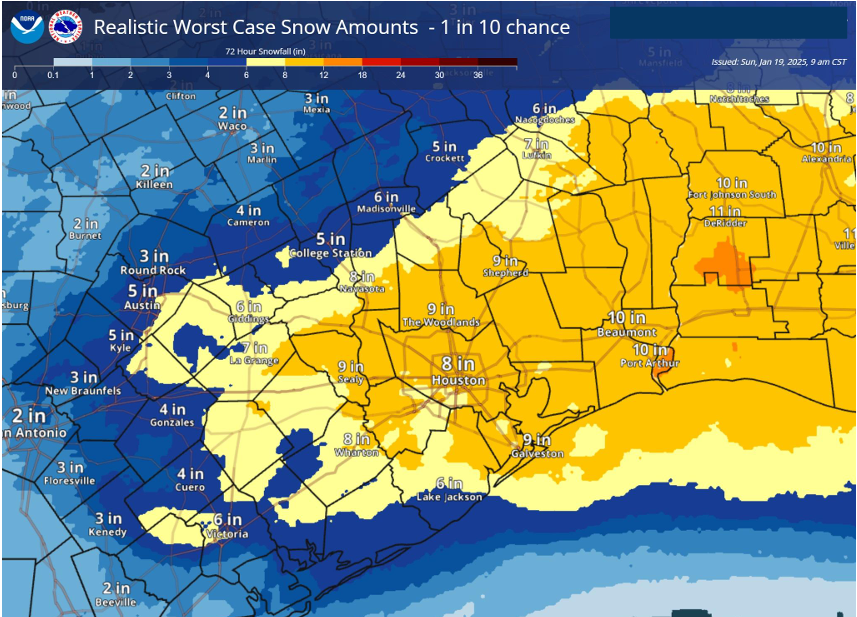
Why has this happened? Well for one, modeling has continued to lock in colder with this storm, showing a sharp transition overnight Monday into Tuesday morning from plain rain, freezing rain, and a mix of sleet and snow to just sleet and probably mostly snow across the region. Secondly, high resolution weather models that only run about 48 to 60 hours out in time are now in range of the storm, confirming both that precipitation-type outcome and the potential for “banding” that will exacerbate local snowfall totals.
Again, we have to note: The snow will not fall perfectly uniformly across the region. Depending on where this “banding” sets up, that will determine places that are at risk for 6 inches or more of snow. Quite frankly, that could be anywhere in our area; we simply don’t know at this time. Recent model runs have favored the Houston through Liberty County areas, as well as Brazoria County through Beaumont areas, but that could easily change. I’d say we’ll know more tomorrow, but realistically, we may not know it until it starts.
Again, just to underscore: As long as the forecast stays on track, travel is going to be nearly impossible Monday after midnight and all day Tuesday. You will almost certainly be stuck where you are until at least later Wednesday morning. The exception to this may be the far north now (like north of Highway 105), where snow may end up lighter, no ice occurs, and roads may clear off a bit after the snow stops Tuesday afternoon. But even that may be optimistic. More to come on this.
Historical context
Realistically, this is the most significant snow threat to the region since Christmas Eve 2004. The 1895 storm stands alone as the greatest on record in Texas and Louisiana, and this storm will not dethrone that one. However, with that in mind, this has the potential to set a modern official snowfall record in Houston, which currently sits at a mere 3 inches back in February 1960. January 1940 also sits at 3 inches. While a few storms since then, including Christmas Eve 2004 have produced higher amounts in parts of the area, from a record-keeping perspective, we have a chance to make some noise.

Could it be a blizzard?
This morning I noted how wind gusts of 40 to 50 mph were possible on Galveston Island Tuesday morning with this storm. That obviously begs the question of whether or not this could end up meeting blizzard criteria. That will be hard. The technical requirements are:
1.) Sustained wind or frequent gusts to 35 mph or higher. (This will be close)
2.) Heavy snowfall or blowing snow that reduces visibility under a quarter mile. (This will be tough)
3.) Three consecutive hours of these conditions. (This will be very tough)
I’m not saying it can’t happen, but given how rigorous these requirements are, I have doubts that we’ll officially get there. But at least now you know what an official blizzard is. That said, we almost certainly will see blizzard-like conditions on the island if those winds come to fruition and a full changeover from sleet to snow occurs.
Whatever the case, we are into some seriously rare winter weather for Houston in what may end up being a generational winter storm. We will have the latest for you in the morning with revised model data at our fingertips.

Thanks for all of these updates!
Will we have more snow than 2004?
Houston probably will, but for the coastal counties, it is unlikely. Between 10 to 12 inches of snow fell across Matagorda and Brazoria County during the Miracle Christmas 2004 snow event. I think Houston only had 1 inch from that storm.
Thanks for all of the updates. We really appreciate it. Q
How did Eric do in the Houston marathon?
He did awesome! He finished right in front of me! I’ll be curious to see if he shares his thoughts on the cold and windy conditions. They were brutal!
Are winds going to be that blustery in Fort Bend County?
Unlikely to be that high inland, but prior forecasts have gusts up to 30 in the cards.
Thank you to the entire team for the hard work you continue to do for our area. I have become so interested in what’s happening and how we got here from your posts. I’m sure it has made for greater safety for us all.
I bet the tourists didn’t bet on hunkering down during the great Galveston Blizzard of 2025! 🥶🥶🥶
Thanks Matt!
What about temperatures?
Has everybody forgotten the blizzard of 2021?
Anyone whose pipes burst after 3 days of no power despite them supposed to be “rolling” (like me) has not forgotten
Same 🙁 I’m VERY curious how this will be different than/not as bad as 2021…
Main thing is that it is localized. Matt mentioned that this morning, I think. The 2021 freeze was all of Texas. Also, we were below freezing for a full week. This sounds like it will be no more than 48-72 hours max.
Not that my citrus, which were trying to bloom again, will care if it’s only a few days.
I know I am bummed about my banana trees
Same here, Both Generators tested and fueled today. Ample fuel stocks to go far past the nightmare of Snowpaclypse duration. I can enjoy the snow this time…
Me too! I bought lots of pop tarts!
hehe
2021 was a terrible winter weather event but it wasn’t a blizzard. The snow fell gently and stopped after a short time, with accumulations of 1-2 inches or so in most places. It was only so memorable because of the bitter cold which kept snow/ ice on the ground for days and decimated the power system. But a blizzard is a whole different animal.
Since you were kind enough to correct someone’s incorrect use of “blizzard,” I’ll do the same for you on “decimated.” It would have been lovely if the winter weather event in 2021 had only “decimated” the power system; sadly it took much more than ten percent offline.
Damn global warming!
I have to apologize to Houston. This will make the third times I’ve moved to a new area and a record (or near record has occurred): first I moved to Dallas in May and that year marked the longest consecutive number of days above 100, then moved to Silicon Valley in August and the following two winters they set rainfall records…moved here in July (actually 2 days before Beryl). So again, sorry Houston, but hopefully everyone stays safe and can enjoy a snow day!
We left Houston last summer and now are in a regular snow area. I like it! Mostly because it’s awesome to see our Houston born dog playing in it.
However the local weather folks aren’t nearly as good as you guys.
Dec 8, 2017, we had around 3 inches of heavy wet snow in my neighborhood in NW Harris County. I have photos! My kids made a 3 foot tall snowman in our front yard. Looking at NWS records, it shows 0.7″ of snow at KIAH on 12/8/2017.
How will this differ from 2021? Will this be worse or not as bad? I guess we’re all just hoping the power holds…
If the forecast holds, this is likely to mean more snow on the ground, but a much shorter duration of continuous below-freezing temperatures. If the power generating stations are able to stay online with their beefed-up winterization, it should hopefully be much less unpleasant to live through.
Thanks for all of the updates! Hoping everyone stays safe and warm.
As long as the grid holds.
How did the marathon go for Eric? That’s the bigger story here!!
I would rather have “banding” instead of “training “.
Let’s see how many people try to drive up the very high toll road overpasses.
WeatherNerd has taken quite an interest in the upcoming “snow event”. Live in Ft. Bend Cty and am amazed we could possibly get 8-10”. Not worried about road conditions, pipes busting will keep me uneasy. Hoping for some good snow pic’s ❄️👀. Eric and Matt, thanks for your attention to detail.
Did you just refer to yourself in the third person? lol
I absolutely KNEW this city wasn’t going to let me leave peacefully. Just waiting for the inevitable power outage and pipes bursting all over my home. Just 4 more weeks and I’m finally out of here. What a ridiculous nightmare this has been from start to finish. I never should have moved my family here. We have hated it the entire time and my wife is more fed than I am. This last little gem is the city’s final middle finger to me. Never again.
Bet you’re the life of the party wherever you go. Had a family move from Canada to our area (Santa Fe) back in the late 70’s early 80’s. Pi$$ed and moaned about the weather the ENTIRE time they were hear. You wouldn’t happen to be from Canada would ya??? Hope you made some good money moving/working (assuming for work) here, because by your description, you’re family is an absolute mess!!!!!
Comments like this give the rest of us Texans a bad reputation.
Houston, like everywhere else, has its pros and cons. I hope you like your new home better.
should have left sooner……
They come, clog the freeways up more, and gripe the whole time. 😂 He’s heard about the hurricanes in Louisiana, Florida, wildfires in CA, the derechos/Hurricane Sandy in the north? Flooding in Ashville? And heatwaves in the northwest like in Oregon melting houses? He knows other states/cities have blackouts right? Guy acts like only Houston has weather 🤣 We have even gone many years without major events.
Hey, Adam! I thought you were gone already. This is definitely a weird bookend on your time in Houston. Best wishes to you and your family in your new home!
Yay Adam is back!! I missed you
Missed you, Adam! Glad to see you here.
Yea the city singled you out 🙄 man what a narcissist
Always enjoy Adam’s honesty ☺️
Don’t let the door hit you. You should leave sooner.
Where did you move from? I feel the same lol
“Generational Winter Storm” does not sound very encouraging! lol
Personally, I’m sick of having to live through “historical weather”. This is the third time in what, 8 months? I’m outta here too in a year or two.
Oh stop Beryl was barely anything. As was the derecho which only affected the North and Northwest. You guys are so weak. God knows how you would handle an actual tragedy like the wildfires in CA.
Depends on where you live. My neighborhood is still rebuilding from Beryl and people were out of power for over 10 days then. Likewise, the fires in California devastated a few neighborhoods, but most of Los Angeles did not sustain any damage.
Beryl was a cat 5 at one point, if you’ll remember – and we’re still dealing with the fallout from this past year’s weather, incl Beryl & the wind storms you so easily dismiss.
I grew up with hurricanes. Now I get to add F2 & 3s, derechos, even more extreme heat & other gifts from the Gulf pho Mexico.
There are primary, secondary, tertiary, etc fallouts from the these intensities. Nothing happens in isolation, and we’re all finding out about the physical and emotional/psychological consequences of these events, knowing there won’t be a break.
So quit making it worse by being a jerk.
Exactly! My family nearly died when 3 big trees from neighbors’ yards crashed INTO their house and garage. It’s been AWFUL. It caused so much stress, cost tons of money, and they are traumatized. They JUST moved back into their house before xmas and there are still issues. Beryl wasn’t “nothing” for a lot of people. 🤬
Looks like the models are backing off a bunch. Going to be funny if this whole thing turns out to be nothing more than a dusting for most of the region.
Peak lack of empathy post. Lots of people were horribly affected.
NWS has really walked back those worst case snow totals now. Hopefully it can stay cold enough for it to be snow instead of sleet. It will be close.
Yes, that 22″ for Harris County was a bit distressing. I think the most I’ve ever seen in my life was maybe 14″ in two days.
Cancun, here I come.
Ha ha, you know Ted came right back to Texas one day after he flew to Cancun to drop his daughter off. He didn’t stay down there during the entire freeze like the media had everyone believing.
Ha ha ha…
Only b/c he was caught 😆. We had pics of him leaving.
To quote Ted himself, he had “planned the trip for the holidays for his daughters, but it didn’t feel right so he came back.” He didn’t go to simply “drop them off”
Here we go with the stale jokes like has Katy evacuated?
No questions about Katy evacuating?
I thought I could go one Houston weather post without this lame joke. Alas, didn’t happen.
It’s pretty fun taking this one hour-by-hour wrt the sleet/snow ratio. I’m sure hoping for that uniformly sub-freezing atmospheric column.
I moved here in 2007 from New England to escape this weather! It’s followed me I swear! LOL 😆
Have ya’ll not figured out yet? Just wait and weather conditions will change! I am 84 , have lived in Texas all my life. Temperature changes fast from minute to minute.