In brief: In this post we take a brief look back at the Francine forecast and some of our exasperations, and then look ahead at a period of much hotter weather. Summer is not over yet, and we’ll discover that this weekend.
A brief word about Francine
Here at Space City Weather we try to get things right. We don’t always succeed—this year we were surprised by a derecho, and our early forecasts for Hurricane Beryl missed the mark. But our commitment to readers is that we’re always going to tell you what we think, in a straightforward manner, without hype or tricks.
Which brings me to last Monday afternoon. I had just hit ‘publish’ on a post about Francine, in which we continued to predict the tropical system would remain far enough offshore to preclude serious impacts for Houston specifically, and Texas in general. Almost immediately after that story went up on the website, we started to get questions here, on Facebook, and by email about a western “shift” in the forecast. Apparently some media outlets and popular social media accounts were reporting on this, suggesting serious impacts were possible in Texas from Francine. Initially, I was stumped. I certainly wasn’t seeing that prospect in the model data.
It turns out this was a reaction to a very slight change in the official track forecast from the National Hurricane center. I bring this up, because I saw something Thursday from hurricane scientist James Franklin that reveals just how slight this shift was. The map below shows a plot of landfall forecasts from the National Hurricane Center over the 78 hours prior to landfall. I’ve added an arrow to highlight the western “shift” in the track that caused all of the commotion:
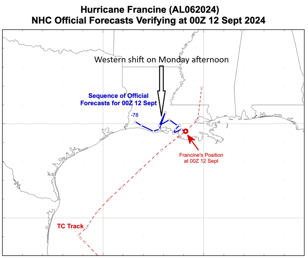
The trend over the weekend had been an eastward one, and there was no model data at the time suggesting a huge shift back toward Texas was imminent. And as you can see, during the very next forecast cycle, the official forecast shifted to the east, and more than wiped out the earlier change. Somewhat exasperated, I touched on this topic in a post at 10 pm that same day.
Why were Matt and I exasperated? Every storm is different. With Francine coming along just a couple of months after Beryl, Houston residents were understandably sensitive to the possibility that Francine would not turn away from our area. Emphasizing this “western shift” played on those concerns. We also recognize that after all of the crazy, wild, and destructive storms, freezes, heat waves, and more that we’ve had in just the last decade, Houston residents can live on pins and needles when inclement weather threatens. The very last thing we want try to do is exacerbate those fears.
Friday
Enough about storms, let’s talk about sunshine. There will be plenty of that this weekend, and beyond, as high pressure more or less asserts control over our weather. Since we’re now into mid-September, with shorter days and a lower sun angle, temperatures are not going back into triple digits, but it will still be plenty hot.
Highs today will reach the mid-90s for much of Houston, except for coastal regions, which will see highs a few degrees lower. Skies will be sunny. Winds will be light at only a few mph, from the west. There won’t be much relief overnight, with low temperatures generally falling into the mid- to upper-70s. So yeah, welcome back summer.
Saturday and Sunday
Expect more of the same, with mostly sunny skies, light winds, and temperatures in the mid- to upper-90s for inland areas. The coast will be a bit cooler during the daytime. Overnights lows will remain warm, in the upper 70s. Could we see a few rogue thunderstorms? Maybe. But I’d put chances at about 5 percent, so probably not.
Next week
The first half of the week will start out with highs in the mid-90s, and perhaps a 10 percent chance of showers on Monday and Tuesday. However, after that we should see temperatures back of slightly, into the lower 90s. Rain chances remain low, with mostly sunny skies, for the remainder of the week, and probably next weekend as well. Our next chance of a front comes in about 10 to 12 days time, but at this point it’s closer to a hope than a certainty.
Tropics
There’s nothing to see here. After writing a lot the last 12 days about Francine and other weather, we’re taking the weekend off. See you on Monday.

How dare you provide rational, science-based forecasting. We need more eyeballs! Gotta pump those numbers up!
As a long time follower, the thoughtful weather analysis provided by you and Matt have been a staple of my morning routine for years. Not every forecast is perfect, but staying grounded in the best science available will always be better than the “mongering” that dominates social media.
Totally agree. The morning routine is walk dogs, make tea, read Space City. June thru September I do look at the NOAA Hurricane Center for any “blobs” then check Eyewall for the explanation. Maybe the t-shirt should be “the data is the data” on the front and “Every storm is different.” on the back? LOL Just as long as it’s not “The answer’s 42”. Enjoy your weekend off.
Love this idea for a tshirt!!
A scientist’s take on the t-shirt idea: the word “data” are plural. Media and others constantly get this wrong, and say “the data is …”. So, in correct tense, the t-shirt should read “the data are the data” .
True! But the word “word” is singular, so to correctly correct someone, you’d need to say, “The word “data” is plural.”
toad just took Susie to school. Susie might be technically correct about data being plural, but in most applications data can be used as singular, using it to mean a set of data. There are lots of discussions about this online and based on my experience only the most anal retentive insist on using data as a plural.
Thank you so much for your reliable forecasting. While it seemed many news outlets were stoking fears about Francine you all were straight forward and spot on.
I watch the local news every morning before work. I didn’t see this “fear stoking” about Francine. Of course they threw a few teasers in here and there to get you to stay on the channel during breaks but they did a fine job keeping to the forecast without hype. Not sure what you are watching.
Thanks for all your great work. With Beryl it kept moving and moving east much to our dismay, in Sugarland and ran right though us. The shifts are stumping the forecasters for sure.
The primary weakness with all models is the misunderstanding that they are a direct prediction of the future.
The true value of models is their assistance in better understanding the range of likely outcomes of an event.
In this case, the overall trench in the path the the east combined with the consistency of different iteration lent confidence to the idea that this storm would hit somewhere in Louisiana, and that a hit towards Morgan City was more likely than Sabine Pass.
Never trust what one iteration of a model is telling you. Look at the trend and the consistency instead.
I hope you both have a peaceful weekend. I enjoy reading your reports every morning!!
Your no hype approach is so appreciated. I have recommended your site to so many who listen to national or local weather and just react to the drama those outlets spew to attract viewers. PLEASE don’t get discouraged. You have developed a loyalty among so many locally and truly depend of your forecasts. Great work guys!
I am finding that some local TV news stations add drama to their weather reports to do exactly what you guys Don’t do: hype for viewers
The local TV stations are the worst! I did like Frank, who seemed to try to minimize hype, and had flipped over to KPRC, they were constantly chirping about “updated tropical information, tune in at 10 for the latest!” and then all they had was fear mongering. Meanwhile they totally ignored the explanation that weak system hugs the coast and we get rain, stronger system veers east and goes to Louisiana. FLEE FOR YOUR LIVES!
What drives me crazy is the way on-air talent is now framed in full body, which encourages them to make wild gesticulations with their hands and arms as way to emphasize just how serious and important what they are talking about is. They remind me of a used car salesman screaming “OUR LOW PRICES ARE INSANE!!!” Do yourself a favor sometime: watch a news or weather report with the sound off. Ha – larious.
This is why I send friends and colleagues a link to your site whenever they get caught up in the hype! Thanks again for your straightforward and dependable forecasts.
Pleasant surprise walking outside this morning. Wasn’t expecting temps in the 60s!
I was born and raised in the deep south – central Louisiana – and well remember the devastation of Hurricane Audrey in 1957. There been many hurricanes and other challenging weather events since then. I long ago determined that among the most difficult jobs on earth is working as a weather forecaster on the Gulf Coast. Eric and Matt provide excellent analysis that is an absolute “go to” for any problems that are so frequent. During Francine, I sent links to several Louisiana friends, assuring them Eyewall was the best site available. All followed closely and were so appreciative for the service provided. Keep up the good work – and ignore the naysayers! You guys are the best!
I don’t know what kind of comments you are getting but my family loves your work. Please keep it up.
You guys rock. Thanks for all you do for us here in Houston!
I always appreciate your honest and practical information. I’ve lived in Houston 45 years so I’ve been through a few hurricanes and know that they can be wayward!
Thanks for all you do, keep calm and carry on.
As a native Houstonion, and having lived here off and on despite military service, I can honestly say I’ve never stumbled upon a weather site that consistently delivers accurate no-hype information to an ever-evolving, complex environment of weather broadcasting. As a fan of weather (yes the original Twister movie, and yes I’ve lived in Oklahoma) I’ve been fascinated by what the Texas Gulf Coast never fails to deliver. I found myself disappointed that I was overseas deployed for Ike and also somehow lived in Dallas for Harvey (again only for my weather fascination, my sympathy for all who sustained hardship). I have been back now for almost 5 years and other than Hurricans Nicholas, Hurricane Beryl was my first significant Hurricane, despite having lived here for Tropical Storm Allison, Tropical Storm Francis, and almost evacuating for Rita. Hurricane Beryl was my first real fan-experience with a big weather event, and I can tell you, although it sucked as far as power outage and damage stand point (living in League City), I never felt more confident in a storms forecast than with that of Eric and Matt. These guys are for real, and all true weather nerds are grateful for all they do! I’ve recommended countless friends and family to their website. Seriously, thank you SCW, for all you do!!!
Eric, you are a very nice guy and it shows in posts like this one. And, SCW has helped “settle down” some of the more alarmist television meteorologists. Much is driven by social media — often by people who don’t even live in Houston — driving fear because they can. Nearly every storm that begins in the Gulf has someone who puts a giant red arrow pointing at Houston with “Ya’ll are gonna get it.” And, yes, layer on the wild weather we’ve had? People are naturally skittish and ready to be scared.
But…this is climate change. Hotter hots, drier dries, coupled with colder colds and wetter wets. A huge drought is followed by tremendous rains which lead to flooding. I’ve stopped asking people if they “believe in climate change” and now ask “do you understand climate change.” The great limiter for Houston and the Gulf will be the continuing withdrawal of home insurers who no longer want the risk. The change isn’t coming. It’s here.
I was not concerned about that westward shift because the account I read was clear on the fact that the shift was not a shift in the whole storm
But in just a small part of it ( was it in the eye?).
Thanks so much for addressing this.
I’m very nervous when I read any other account of what’s about to transpire with a weather happening unless it’s your account. I hate the hype.
So, a massive 10 mile jog west in a single prediction wasn’t enough for you guys to stoke fears for eyeballs? The shame. seriously, though, we’re lucky to have you.
Appreciate you guys so much! You deserve a weekend off!
Yes, you guys rock. And would buy that merch!
I have followed SCW since Harvey where you guys pretty much nailed it. I like how you differentiate between what you’re pretty sure is going to happen and what could happen if “the stars align”.
And you’re always ready to admit if you get it wrong (doesn’t happen often though!) and then you explain why you got it wrong.
Your time and efforts are very much appreciated by us all.
Enjoy your weekend off!
Dear Eric and Matt,
In response to Eric’s comment about being exasperated, please keep doing exactly what you are doing. Your fabulous expertise, combined with common sense and a healthy dose of good humor, mean that you are the only weather professionals to whom I pay attention. You have 100% of my trust and gratitude Keep up the good work and keep on keeping on.
From your respectfully devoted fan,
Tori Williams
Exasperated and exacerbate in the same paragraph! Nailed it. You guys rock.
Apparently a number of non-meteorologist spent the night in a La Quinta and woke up experts, lol. You guys do an excellent job keep up the good work.
Keep up the good work, you are a bastion of reasoned analysis in a sea of hype and fear-mongering
I for one trust you much more than any other weather service. You are the best, but weather is not an exact science, and it changes UNPREDICTABLY often. Those who don’t understand this should go to the weather forecasting service that they want. No one forces them to stay with you. As for me, I’ll continue to trust you and look at your forecast daily.
FRANCINE DRILL
Like a fire drill at school and work, let’s consider Hurricane Francine a hurricane drill. Citizens were given an opportunity to prepare for possible tropical malfeasance.
Eric – you and Matt do an incredible job and, as you well know, many of our media outlets are focused on a worst case scenario rather than simple logic. These are meteorologists?? We’ll trust you before we join many of our panic stricken neighbors who now have more water and food than they’ll need for the next 6 months. Keep it up, we appreciate you.
Space City Weather is just awesome! Anybody that thinks otherwise is nuts!
I don’t take models as serious with westward shifts when the storm is east of us nearly as I much as I do them trending eastward when the storm is west of us.
I’ve just seen to many eastward shifts in model guidance over the years.
Yesterday was the first 90 degree day for Bay City this month. It is very unusual to go 11 days into September without one 90 degree day in this area. I’ll take it.
And I will forever read and trust this website and my email from space city. Thanks M&E
The entire ‘Western Shift’ nonsense got picked up by local news.
‘We’re all gonna die – tune in at 10!’
Another reason to stay connected to this site – no hype.
Also joining in on the praise for you guys. Best weather ever!
I can hardly watch our local weather reporters. It’s more hype than facts. Sensationalism. I appreciate Space City Weather’s information without the drama. Thank you! As Joe Friday used to say, “the facts m’am, just the facts”. Joe would be proud of you!!!
Y’all are doing just fine.
I shared the Eyewall with a colleague in North Carolina, and I was grateful to be able to do so.
When I travel I’m a little sad that not everyone has a SCW.
Keep doing what you’re doing
In my brain “48 hours” is last time a big shift will happen, over 200 miles landfall, agree??? Past shifts we hear of in the past were past 48 hours. At 10 miles an hour this is 480 miles so halfway to Cozumel, mid Gulf of Mexico, northwest of this Cozumel, Mexico City, West Cuba, Key West, this is the “reliability line”????? I also think the eastward side is 10x more windy and destructive, one wishes the hurricane shape could be a oval with the east side bigger, and the cone of uncertainty NOT DRAWN SYMETTRICALLY ON SIDES OF THE LIKELY PATH. Instead, use 1/2 shrunk on left side to show really what areas should be terrified (yes logically this is hard to be perfect, but still it would help on average). . . Or maybe not. Thanks.
The “cone of uncertainty” is the projected path of the storm’s center. Depending on the size of the storm, effects can extend out quite a ways from the center, but that is not what’s being shown by the cone. The line down the center of the cone is the most likely path the center (generally the eye for hurricanes) will follow, but the center could deviate in either direction on either side of the line within the bounds of the cone.
Yes. The cone I think is designed so 90% of time it includes the actual track. But it does NOT change size, so it can overscare or underscore people, since size does matter to degree of risk of hi hi winds …… Yes I get how the middle and edge lines work, still the odds of hi winds is much higher if on right side of cone ….. Sigh, it’s hard to think of it mentally, but the odds of damage if to the east of the storm is like 2x maybe, so a person to east side of cone should be more terrified. Hmm picture it as a boxer and his right arm is WEIRDLY huge and swinging and landing huge blows and left arm is tiny and landing weak blows — if to the right side of cone there is greater chance of strong right arm swinging 20 miles or so hitting a heavy blow on you, and small but yes nonzero chance of hurricane meandering so much the weak left arm will hit ya… Get it? The boxer has like 20 miles right arm, and 10 mile left arm…. I have a boat and storm surge especially is mega worse if storm is to east of us…….. I know this is hard to describe, but those on right side of cone do have greater hi wind risk yet nothing shows then this ……
Just had a random downpour develop over Sweeny and dumped over an inch of rain in just 30 minutes. Doesn’t look like anywhere else got rain today lol
Exasperation? The Wall Street Journal had a piece the other day about the election (you know which one). The emphasis was that with the proliferation of social media people will now believe anything and react to anything—no matter how idiotic. I’m 81 years old. Have no social media interaction. Get my information from traditional media. Am astute enough to place my own interpretation on what I read/see. For Beryl I followed SCW and Radar Pro—until I lost internet of course. The only surprise I got was the amount of destruction. The last radar image I got showed it moving right over us here five miles NE of West Columbia. Ten miles west of us and all along HWY 36 to Bay City you would not believe there had been any storm at all. ITS THE WEATHER, PEOPLE. SNAP OUT OF IT! You go, SCW Guys.
I STOPPED watching network news and particularly Weather – THEY EXAGGERATE TO KEEP HANGING.
Once we learned about you!
This time we were in North Carolina when this thing showed up. We were tracking the storm with you and made careful decisions taking your inputs into account.
We did not even change our flight back home on Wednesday night. The plane was half empty. We got home ahead of schedule.
You have no idea how much your writing means to one of those individuals who can be on pins and needles. Your words were the light in the threatening storm. Today you again topped yourself by truly expressing how some may feel…”We also recognize that after all of the crazy, wild, and destructive storms, freezes, heat waves, and more that we’ve had in just the last decade, Houston residents can live on pins and needles when inclement weather threatens. The very last thing we want try to do is exacerbate those fears.”. It felt like you took the time to understand me. The words “Thank You” seem inadequate, but I was raised that anytime you are thankful, you should express it. So with my thanks, I will also wish you a well deserved GREAT weekend.
You have to also include people who comment here in that they found a long range model showing a hurricane hitting TX when its just barely a tropical wave. Or just trolls in general that want to start drama