In brief: Monday will be calm, but you should anticipate the potential for showers, thunderstorms, and heavy rainfall on Tuesday and Wednesday in the Houston metro area. We don’t have high confidence in the timing yet, but with the atmosphere in place we can be pretty confident in disruptions, and have put a Stage 1 flood alert in place through Wednesday. Things calm down after that.
Weekend review
You would be hard-pressed, I think, to expect a finer weekend in early May than we just experienced. My wife and I were at a choir event on Sunday evening at the Willowynn Barn in Santa Fe—a gorgeous place for events by the way, I joked with Amanda that I would like to have my next wedding there—and you just had to stand outside and soak it up. Summer is on the horizon.
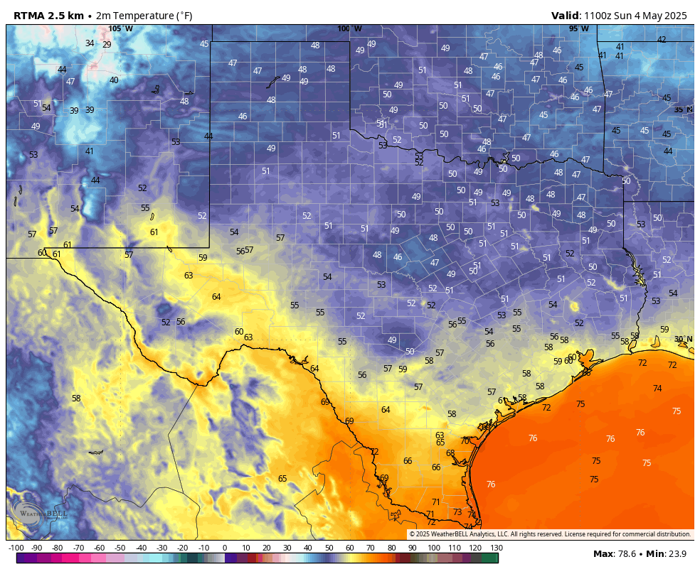
Inland areas got into the 50s on Sunday morning in Houston, and most of the rest of the area enjoyed the lower 60s with drier air with dewpoints in the 40s. That’s really pleasant for May. I do think we’re going to see another weak front for next weekend, but unfortunately it’s unlikely to pull as much drier air with it. And first we’ve got to get through another stormy pattern.
Monday
Humidity is already on the rise this morning, and we’ll see southeasterly winds gusting up to 25 mph that will set the stage for more moisture in the air. We’ll start out with partly sunny skies this morning, but by some point this afternoon we should see mostly clouds. High temperatures will reach the vicinity of 80 degrees. By this afternoon and evening we will see some scattered showers, mainly located to the west of Interstate 45. A chance of light rain will spread into the entire region during the overnight hours as lows fall to around 70 degrees.
Tuesday and Wednesday
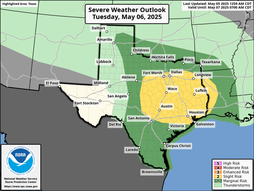
The moisture that moved inland on Monday was a “warm” front, and it will set the stage for the possibility of heavy rainfall and storms on Tuesday and Wednesday in the Houston metro area. Our various high resolution models still have some discrepancies, but right now I would predict that the greatest potential for inclement weather will occur from late Tuesday morning through Wednesday morning across the region.
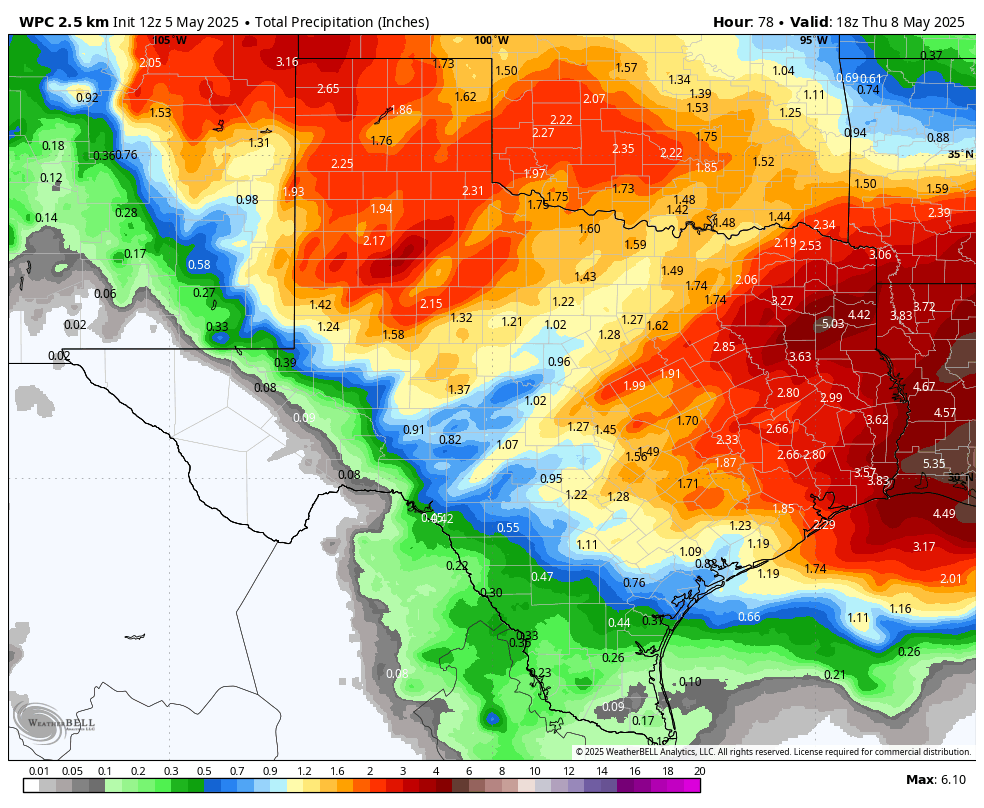
There will be the usual threats: damaging winds, hail, and possibly a tornado. We are also concerned about the potential for heavy rainfall. Most areas are likely to pick up 1 to 3 inches of rain through Wednesday, but we could see some higher bullseyes of 5 inches or more. For this reason we are going to institute a Stage 1 flood alert from Tuesday at noon through Wednesday. In terms of temperatures, Houston should reach the lower 80s on both days with plenty of humidity. We’ll have more on this later today and plenty of coverage the rest of the week.
Thursday
Rain chances should diminish by Thursday, but will perhaps not go away entirely until the afternoon. Expect partly sunny skies and high temperatures in the low- to mid-80s. Lows on Thursday night should drop into the upper 60s.
Friday, Saturday, and Sunday
As a weak front drifts into the area we should see another nice weekend. I don’t know if we’re going to run it back and have things as nice as we just experienced, but as of now I anticipate mostly sunny skies with highs in the low 80s, overnight lows in the 60s, and modestly drier air. So if it is not cool as this past weekend, it will hopefully at least be somewhat pleasant.

“I joked with Amanda that I would like to have my next wedding there”
It must be difficult typing in a full body cast.
Eric’s middle name is “danger”. He knew what he was doing!
Need a divorce lawyer, just call DIV-ORCE.
Eric and Matt, for Houston Metro, is this rain event a close call for a Stage 2 ?
The post says they will have more info later today regarding tomorrows rain Best to wait till then for updates
I would like to know the answer to Matt J’s question as well. Last week was, what?, almost double the projection (I totally get the caveat of possible higher amounts, but double up around Lake Conroe is a very bad scenario). If this is a possible Stage 2 – that’s prep for flooding Stage. :<(
Ari … if you ARE in the Lake Conroe area, SSW is not really focused for folks up north of Harris County (and as is with us in Magnolia, ie, Montgomery County).
Out here on SSW, we read a lot of “north of i-10” and “south of i-10” predictions. Heck, we’re north of 99 , or better yet “south of 105”.
We got drenched here recently, as you allude to – and quite frankly, it’s way better we got drenched without an accurate forecast specifically for Mont. County. We had zero negative side effects of the drenching rain, other than the positive of feeding the pastures with much needed water.
SSW is just one weather resource we use, plus Mike C. at fox26 in the am, plus keep an eye on NWS Radar site.
Oh, I follow NWS like a hawk! We are downstream – Kingwood area, south of San Jac River, so I worry way more about the watershed over Lake Conroe than I do about rain down here! They are still releasing from last week’s rains and expected to get several inches more, so that release will increase. It’s why we flooded last May. (sad face here)
Oh yea – it’s full isn’t it. Hard rain over Conroe starting ~11A tomorrow.
Don … so far, two different weather sites we use predict 80% chance of rain THIS afternoon for “areas north of Harris County”. So, for us, it’s time to drive to HEB and get back before the rain begins 👍
Yea, Conroe is not necessarily near us, but it’s part of the area predicted for later today.
Two features: Light rain from a warm front today. Heavy rain tomorrow late morning onward from the Pacific Baja trough. Eric’s post is defining.
Quote: The National Weather Service has issued Severe Thunderstorm Watch 225 in effect until 8 PM CDT this evening for the following areas. In Texas this watch includes 11 counties.
It’s obvious the Counties… It’s pretty dark out right now … and based on what we see on NWS Radar, we should see rain soon 👍
Yesterday’s Eyewall was interesting. The cuts to NOAA, with hurricane coming up & all that. If I read the Passback document correctly, it’s saying that NOAA (the services it currently performs) will be absorbed into the DHS.
hurricane season
Department of Homeland Security??? You’re kidding, right?
No, I’m not kidding. If you go to the Eyewall for yesterday, click on the link (in the paragraph) & take a look at the Passback document.
“Passback proposes to move the Space Weather Prediction Center (SWPC) from
NOAA to the Department of Homeland Security to better align with DHS’s mission to
protect critical infrastructure. Under this new construct, DHS will take on the
operational mission to predict space weather events and disseminate space weather
products and warnings.”
It surprised me, too. Weather as a national security issue.
That’s good….makes more sense than under Commerce huh? I am absolutely positive hurricane tracking will be front and center when the dust settles. Fla Whitehouse and all. What won’t be is climate research. Already seeing some evidence that anything with the word ‘climate’ in it is getting shuffled – I’m having to redo several bookmarks lately.
No, it’s not a good thing.
Currently severe storms moving through Matagorda and Brazoria County with 1.25 inch hail.
Yep – drenching rain as anticipated earlier.
And to add to the rain, green pea sized hail pounding down. So far, 30 minutes worth of rain, and more on the way up here.