In brief: With high pressure backing off for a few days, rain chances will be higher during the first half of this week. We also take a look at what is likely to come, weatherwise, for the remainder of summer in Houston.
Past is prelude?
As we often say here on Space City Weather, there are many definitions of summer. From a strictly meteorological standpoint, summer comprises the months of June, July, and August. In practicality, September is almost invariably a summer-like month in Houston as well, at least the first two or three weeks. So today we are going to take a look at what the region can expect during the next three months—effectively the rest of summer.
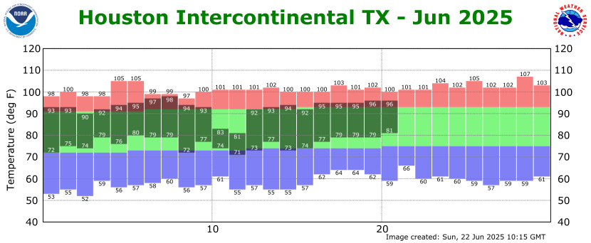
First, let’s look back at what has come so far. June, to date, has not felt super hot. However this has been masked by a relatively cool spell during the middle of the month when the city received widespread rains. There was about a week when the high temperature ranged from the 80s to lower 90s. At the same time, the city has also had more than a week of highs that reached 95 degrees, or higher. This is above the “normal” high for Houston, in June, 92 degrees. So when you add it all up, the average temperature this month is running about 2 degrees Fahrenheit above normal.
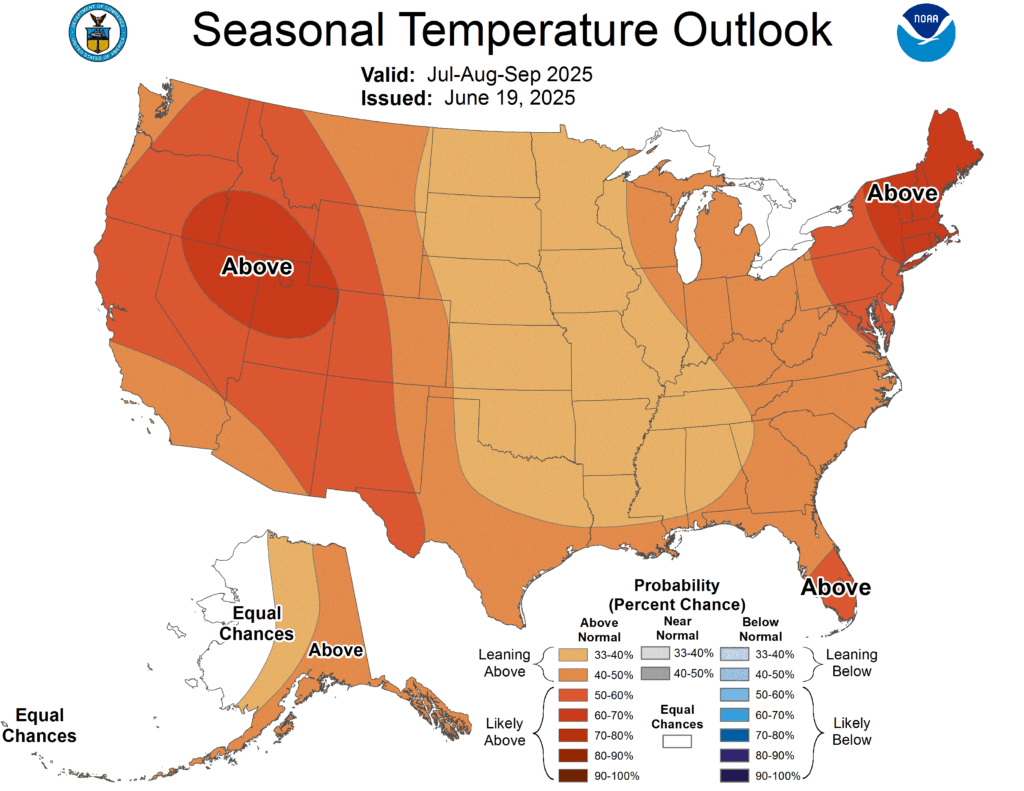
Looking ahead to July, August, and September, I rather think this is what we are most likely to see for the remainder of summer. Houston will probably see warmer than normal temperatures, but nothing too extreme. In other words, July and August are likely to bring plenty of days in the mid-90s, but perhaps only a sprinkling of days in triple digits. In terms of rainfall, the various seasonal models indicate near-normal precipitation for the remainder of summer. Hopefully this rain is fairly evenly distributed, rather than the result of one or two tropical systems. But of course that is something we cannot predict at this time.
Speaking of the heat, our partner Reliant offers a “Beat the Heat” program during the summer months to provide more than a dozen cooling centers across the Houston region. You can find a list of locations here. There is also a payment assistance program for people struggling to pay their electricity bills during the summer.
Finally, I want you to be on the lookout for a post later this morning, at 10 am. Last week I shared a tip on how I survive the summer, psychologically. You responded with some great suggestions of your own, and Dwight Silverman has collected them in a post. It’s great fun and I admire your creativity.
Monday
As we saw on Sunday, Houston’s atmosphere is a little more open to rainfall with high pressure having departed the region. That pattern will continue today, with rain chances of perhaps about 30 percent. To go along with this we will see partly to mostly sunny skies and high temperatures in the low- to mid-90s. Afternoon winds will peak at about 10 mph from the southeast, with higher gusts. Lows tonight will drop into the upper 70s.
Tuesday and Wednesday
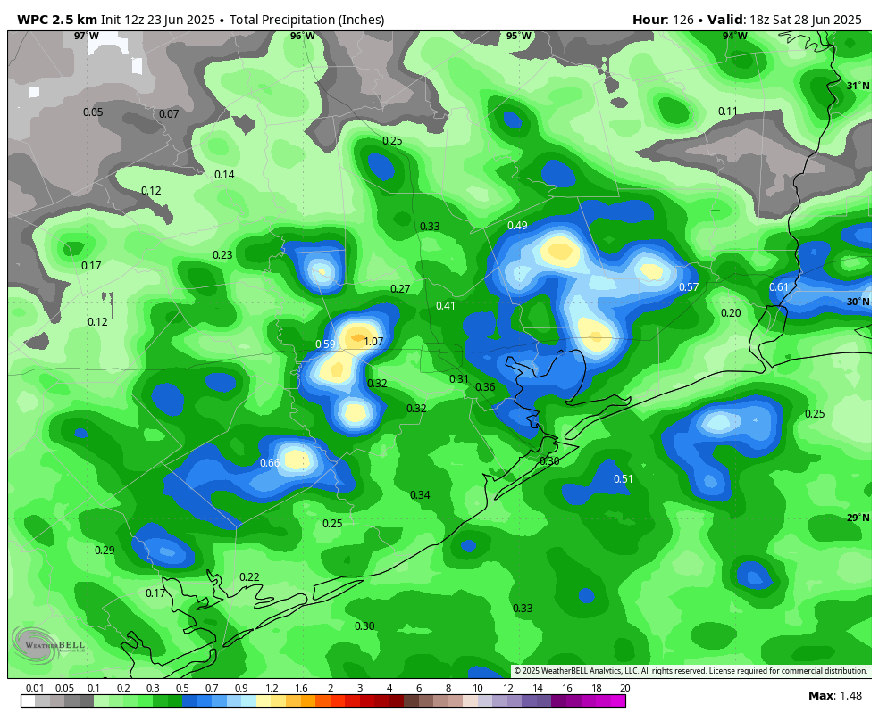
The middle of the week should have the best rain chances, with probably at least half the area receiving rainfall each day. These will be the kinds of storms where some parts of Houston quickly pick up 1 or possibly 2 inches of rainfall, and many other areas see on the order of a tenth of an inch, or two. In other words, they will be hit or miss, and it’s not really possible to forecast right now where the heaviest rains will be. Highs both days will likely be in the lower 90s, with partly sunny skies.
Thursday and Friday
Rain chances will drop back to about 30 percent, daily, to end the work week as our atmosphere becomes a little bit more stable. As a result expect mostly sunny skies and warmer temperatures, with highs in the low- to mid-90s. Nights remain warm and humid, of course.
Saturday, Sunday, and beyond
Saturday’s weather probably will be a continuation of what we experience on Thursday and Friday, but by Sunday rain chances may be on the upswing again. At this point my expectations for Sunday into next week are ongoing daily rain chances in the vicinity of 30 to 50 percent each day, with highs in the lower-to-mid 90s. In other words, this pattern of fairly typical late June weather may well continue into early July.

Love it! No drought whatsoever here and pretty much every else except the southwest.
It truly shows the state our climate is in that even with rainy weather without full influence of high pressure and we are still running 2 degrees above average.
Consistently warmer ocean and air temperatures in the tropics are to blame for us being above the 30 year average 95% of every year now.
The rains this summer thus far have been good but idk how long it will last. I am not relaxing knowing that high pressure tends to strengthen its grip over us tenfold in July and August. And the ground dries very fast during the summer months especially since our summers are much hotter and longer today than they used to be.
This is hardly rainy weather. 0.07 inches the past week.
Any rainfall will be helpful, relax
It briefly reached 98°F here in Jersey Village before the clouds moved in.
Climate, Drought, and Thunder have drawn rain! At least in the URBAN CORE. A learning: one can still have noisy storm cells even when the upper ridge measures 593 (i.e. strong). How bout that.