In brief: Following a period of rainy weather, a cool front, and some lower temperatures due to the passage of Hurricane Francine, Houston is going back into the mid-90s this weekend. Moreover, pretty much all of next week looks fairly hot and sunny. It won’t be August-hot, but after a taste of cooler temperatures it will be plenty hot.
The return of summer
It may be difficult to remember, but not all that long ago Houston recorded seven straight days of 100-degree temperatures. That period of peak summer ended 21 days ago. That’s when, during the last week of August, we started to transition into a rainy pattern, with high temperatures of around 90 degrees or below most days. Then we got our first fall front, and the passage of Hurricane Francine allowed the trend of cooler days to continue into this week.
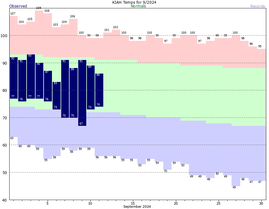
As a result the Houston region has had about three weeks of cooler than normal days (nights have been more in line with climate normals, except for a few nights after the front). Well, I hope you’ve enjoyed it. Because high pressure is back, baby, and it’s bringing summer with it. We’re not returning to the days of 100-degree temperatures, but we are going to jump back into a period of substantially hotter days. I’m not sure when it will end.
Thursday
Today will be something of a transition day, with high temperatures of around 90 degrees or a bit higher. We should start out partly to mostly cloudy in the morning, but by afternoon we should see clearing skies and light northwest winds. Lows will drop into the lower 70s for most of the metro area.
Friday, Saturday, and Sunday
There won’t be much to distinguish these days. All three should see mostly sunny skies, with temperatures solidly in the mid-90s for most locations away from the coast. This is fairly warm for mid-September in Houston, but certainly we often see these kinds of warm stretches this month. It’s not as bad as August, but it’s still pretty hot, and sometimes excruciatingly so in September as we eagerly await the onset of fall. But for those who like summer, and I know there are some of you thermophiles out there, this is a good opportunity for water outdoor activities before things cool off. Nights will only drop into the mid-70s. Humidity will be pretty high, but not as high as it gets during the peak of summer. Rain chances will be close to zero over the weekend.
Next week
The ridge retreats a bit next week, and this may allow for some slight rain chances on Monday, maybe in the 20 percent range. Still, most of next week looks pretty sunny, and highs are going to be in the low 90s most days, with the possibility of a few mid-90s here and there. So yeah, pretty hot and mostly rain-free probably. Our next front may be in the cards about 12 days from now, but I wouldn’t bet on it.
Tropics
Francine has moved inland, and while there are a lot of tropical blobs out there, right now it looks as though none of them are coming toward the Gulf of Mexico. We just need that pattern to hold on for a few more weeks…

If high pressure keeps the hurricanes away until fall I’m ok with it.
Agreed
In Houston weather fashion, looks like we have to pay back those couple of cooler weeks we had. Oh well, 2-3 weeks of summer left. Hang in there y’all, a cool front will undoubtably have to drop in and I reckon it will be a potent one; Fall Day-like.
75 degrees F dewpoint this weekend and forecast with 60-100% relative humidity. I’m ready for my socks to get soaked, are you?
What causes the Houston hurricane risk to drop off? Is it westerlies? Is it start of cold fronts sweeping through? What are you looking for?
Yes. Mainly the cool fronts blowing through.
I wouldn’t bet on us seeing another cool front until early October. Although sometimes we can get our first decent front anywhere between September 22nd and 30th. Hopefully that happenes this year.🤞🤞
For most hurricanes where we’re on the clean side of the storm, the storm tends bring us drier air as the rotation is bringing our wind off the land (from the NE) rather than the usual humid Gulf flow. For Francine however, this did not seem to hold as it was pretty darn humid both Tuesday and Wednesday – why the change this time?
I think it is because with the NE winds there is still some humid gulf air mixed in. To get the noticeably dryer continental air the winds would have to be coming out of the Northwest.