Good morning. After a final flirtation with the 50s this morning we are going to see gradually warming temperatures through Saturday, when parts of Houston may hit 90 degrees for the first time. A front on Saturday night will put an end to that. We should see some showers and thunderstorms ahead of, and along with the front, but the overall chance of severe weather now looks fairly low. Sunny and pleasant weather will follow.
Thursday
Houston has enjoyed several days of a northeasterly flow, but all good things must end and this will too, today. As the onshore flow gets going we will see gradually rising humidity levels and temperatures through Saturday. Highs today will reach about 80 degrees with mostly sunny skies, with relatively light southerly winds this afternoon. Low temperatures tonight will drop into the low-60s. Rain chances are near zero.
Friday
As the southerly flow intensifies, we’ll see stronger winds, perhaps gusting to about 20 mph. The increased moisture in the atmosphere should lead to partly to mostly cloudy skies, and this should help to limit high temperatures into the low-80s. Overnight lows won’t fall very far, likely only to around 70 degrees.
Saturday
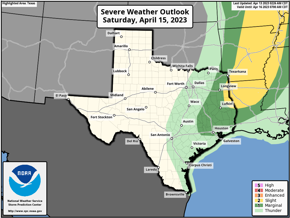
The first half of the weekend will be hot, with partly sunny skies and highs generally in the upper-80s. A few areas will probably hit 90 degrees with the warm southerly air. Some showers and thunderstorms will be possible on Saturday afternoon, evening, and night, but the models have backed off accumulations a fair amount. This means that overall rain chances are now about 50 percent, and totals will likely be on the order of an tenth of an inch, or two. The best chance for rain and severe weather, with the front, look to be northeast of the Houston metro area.
Sunday
Skies will clear out on Sunday morning, with breezy northerly winds. Look for highs in the upper-70s and chilly conditions overnight as lows drop into the low-50s for most of the area. Aside from some occasionally gusty winds—which should be perfect for flying a kite—this will be a fine day to be outside.
Next week
Monday should be another sunny and fine day, with highs in the upper 70s. After that a southerly flow returns to Houston, setting the stage for some rain showers on Tuesday and Wednesday, and warmer days in the mid-80s through the weekend. Overall, April will be doing April-like things.


Weather is not an exact science as evidenced by last evening’s storms. But thanks just the same to SCW for trying to forecast it. 😃
The rain yesterday was quite interesting! Some places got an absolute downpour and then absolutely nothing just a block away. Just typical spring showers in Houston – brings some spice to the daily routine.
I know it’s a ways out, but any early thought’s for the weather the last weekend of April, MS 150 5pm again.
Why does it seem all the best rainfall always happens NE of Houston into Louisiana and also on the Gulf much more rainfall on Louisiana coast than us?
Great, humidity returning to Houston, dreams really do come true, said nobody in Houston, ever