In brief: Temperatures in the Houston region soared into the upper 90s this weekend, but with the departure of high pressure our atmosphere has now been cracked open to storm activity. There will be a healthy chance of showers and thunderstorms all week, which will help keep a lid on temperatures.
Weekend heat
The city of Houston did not set heat records this weekend, but we came close and the temperatures outside offered a preview of what we can expect later this summer. The record highs for both Saturday and Sunday were 99 degrees (set in 1903 and 1980, respectively), and we hit 97 degrees on Saturday and 98 on Sunday at Bush Intercontinental Airport. Combined with humidity and warm nights, it felt like deep August out there. Alas the climatological ‘peak’ of summer heating in Houston is still about two months from today. Now, at least, a reprieve.
Monday
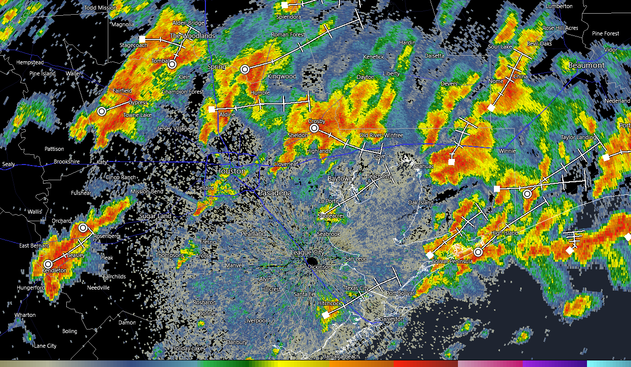
A line of storms is advancing upon the Houston region from the north, and as of sunrise it is moving into the central metro area. These storms are relatively slow-moving, and will work their way through the city and down to the coast by around noon. We are not seeing too much in the way of severe weather with these thunderstorms, but they could certainly produce some ponding on roadways and cause some brief street flooding issues.
Skies should clear out later this morning, and this should allow high temperatures this afternoon to push into the low- to mid-90s. With this daytime heating we may, in turn, see the development of some additional showers and thunderstorms this afternoon or early evening in central Houston. Lows tonight will only drop into the upper 70s.
Tuesday, Wednesday, and Thursday
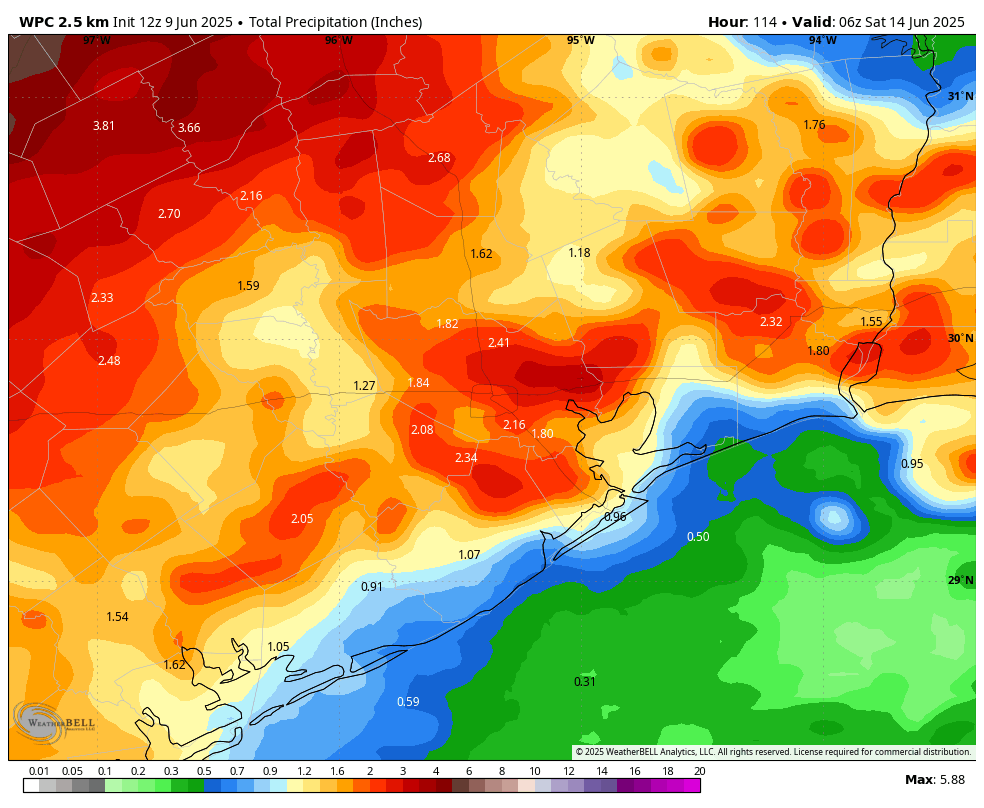
This period should see unsettled weather. In the broader picture, with high pressure having departed, a series of disturbances will produce healthy rain chances each day. Again, we cannot entirely rule out the possibility of some damaging winds or other severe weather, but the primary threat during this period will be the potential for heavy rainfall.
Overall, I think this will be manageable, with most of the area picking up between 1 and 3 inches between now and Thursday. But this is Houston, we’ve reached summer, and there is always the potential for heavy rainfall that briefly backs up streets. This is a function of a) living near a very warm body of water in the Gulf of Mexico and b) living in a relatively flat city where it takes time for tropical rains to drain. But I don’t expect it to rain all the time, and some locations probably will not see rain some days.
Daily high temperatures will be dependent up cloud cover, and when and how much it rains during the afternoon hours when it typically is hottest outside. But each of these three days should see highs in the vicinity of 90 degrees, with some locations a bit above, and others a bit below. Although daytime temperatures will be a bit cooler, humidity will be plenty high, and you know those nights will be warm and muggy.
Friday
Skies should turn a bit more sunny as we get toward the weekend. Expect highs in the lower 90s. Rain chances will still be decent however, at least 50 percent for much of the area.
Saturday and Sunday
Daily rain chances remain on the menu this weekend, probably about 50 percent each day. Overall accumulations should be quite a bit lower this weekend, i.e. I think the potential for street flooding will diminish. Probably. Expect highs generally in the lower 90s, with partly sunny skies. Nights will only fall into the upper 70s.
Next week
This overall trend should persist into next weekend; that is temperatures probably will remain the lower 90s with a decent chance of showers each day. If you’re bummed about the rain, I get it. But this is the kind of pattern that really helps set our region up nicely for the typically hot and dry patterns we can get locked into in July, or August, or both.

Storms = Power Outages
I’d rather have the arid dry summer personally.
I’ll take the other side of the coin. Overcast skies and some rain keeps a lid on the temperature. No one is going to freeze at a high of ~92 degrees.
Is the Saharan Dust still around?
Still remnants. Low fronts typically wipe out most of the dust due to rain washing it out. You can see a pocket of it in windy with the PM2.5 map: https://www.windy.com/-Menu/menu?cams,pm2p5,28.111,-84.287,4,i:pressure
It also shows how bad the Canadian wildfires have been up north.
As of right now, there is some dust over the Atlantic, and some dust over the Caribbean. Very little to no dust over the Gulf.
Interesting fact about June heat. In June of 1902 the mercury in Houston hit the triple digits 10 times and we topped 96 a staggering 16 times. The odd part is we were only .07 degrees above normal that month because the nighttime lows were so much cooler than present. The average low was 71.2. I would love to get an explanation on just why most of the warming is in our nighttime lows? Urban heat island? Increased Gulf SST’s? Increased humidity restricting radiational cooling?
Personally, I’ll take rain over 100 degree days. Although when we cruise around the century mark it does tend to be a bit dryer, so there’s that, I guess. Thanks for do your thing, Space City guys.
*do(ing)
Climatological ‘peak’ summer heating is on the summer solstice, June 21st, right? As in, the rate of heat addition is highest on the solstice. However the climatological ‘peak’ observed temperature is usually around early August, right?
Am I confusing these terms. Is the rate of solar heating actually higher in August than the solstice?
You are right, the sun is stronger in June than in August from solstice. in fact, the sun as strong in August as it is in April, think of August as a preheated month that has a strong enough sun to heat it even further, whereas April is still spring precooled from the winter.
Ummm. These comments from folks who haven’t lived here and don’t use outside water or AC, I think. The climate is hottest in August. Not the solstice. For the others – you will save $100-200 this week in water (for grass and plants) and electric. That’s money…and no, don’t taunt the ridge god.
“Don’t taunt the ridge god” should be an unofficail slogan of SCW
Storms are gone – the brief rain began about 6.30am, and lasted about 30 minutes.
Interesting side effect – at 6.30 it was 73°F outside – and now, two hours later, it’s 71°.
It was 69°F briefly where I am, until the sun came out.
I was going to post a question about this to Matt or Eric, because 30 min after our showers here in Sienna, it honestly felt like a cool dry morning in the middle of October. I was shocked at how nice it felt outside. Of course, 30 min later all that was gone!
These are those humidity slap you in the face kind of days. YUCK.
Well , a nice surprise now – a bit of a dumping rain/thunder up here in Magnolia. A nice addition to the 30 minute rain this AM.
Wasn’t expecting it, so just checked NWS Radar – a glob around us and I see another out in Sealy area, moving to east.
And another surprise… temp has dropped to 77°F !! whoop 🙂