In brief: Today’s post reviews an unseasonably warm April and then looks ahead to some dynamic weather on Friday. Much of the region should see storms between Friday afternoon and Saturday morning as a slow-moving cool front moves into the region. After this, the weekend looks quite nice for early May.
May arrives
If April seemed rather warm, you’re not wrong. The month ended last night, and for the greater Houston region it was a seasonably sizzling one. The city’s average temperature was 74.6 degrees, which is nearly 5 degrees above normal. This ranks as the fourth warmest April of all time in the city’s history. One reason is that the city saw no real fronts during the second half of the month. But that does not mean summer has quite yet arrived in Houston. A modest front will reach the city this weekend, and another one is possible about 10 days from now. These won’t be strong fronts, as such things are rather rare for May. But any dry air this late into the spring season is welcome.
Thursday
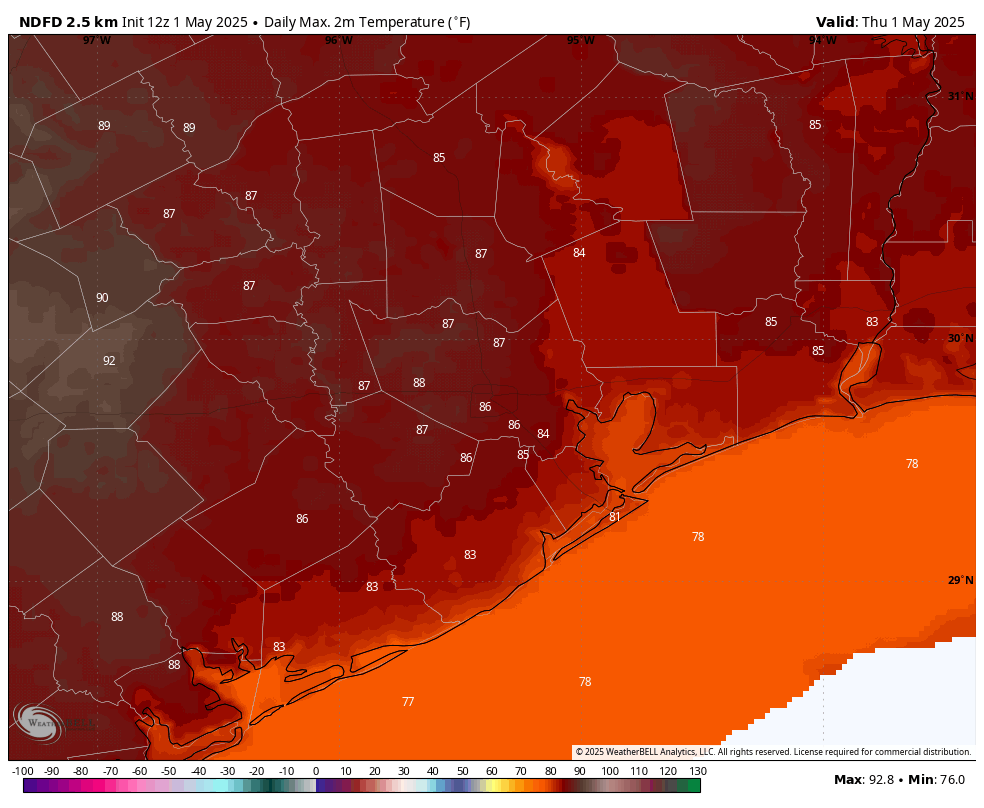
If you’re wondering about those storms on Wednesday night, they essentially remained north of Highway 105, with only a smattering of rain making it down into the Houston metro area. Plenty of moisture remains in the atmosphere so we may see a few showers and thunderstorms today in Houston, but I expect most of us to stay dry. As skies clear out this afternoon, it should be rather warm day, with a few inland locations probably reaching 90 degrees this afternoon. Winds will be from the south at 10 mph, gusting perhaps to 20 mph. Lows tonight only fall into the low 70s for most locations.
Friday and Friday night
In terms of temperatures and humidity, I expect Friday to be similar to Thursday, however I do expect to see less sunshine. The big thing to watch is the possibility (likelihood, really) of showers and thunderstorms on Friday afternoon, evening, and overnight. As a front approaches Houston we are likely to see a mass of showers and thunderstorms develop north of Interstate 10 by Friday afternoon or early evening, and we cannot rule out some hail or damaging winds with these. Although I believe the formation of tornadoes is unlikely, I cannot say none will occur.
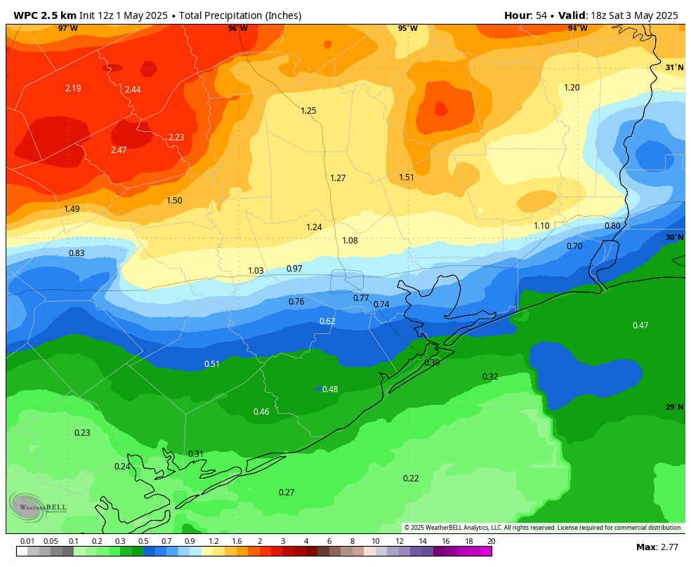
Later on Friday evening, or perhaps around midnight, these storms should march southward toward the coast before the whole thing moves offshore some time on Saturday morning. Because we are still nearly 48 hours from all of this, we are just coming into the range of high resolution modeling. However I want people to be aware that the region could see 0.5 to 2 inches of rain on Friday evening and night, with the possibility of thunderstorms. If you have plans for Friday night, this is definitely something to take into account.
Saturday
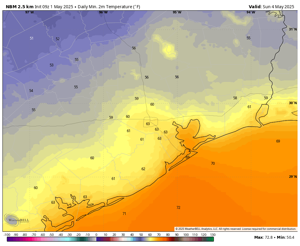
Rain chances will likely end on Saturday morning, and we should see some clearing skies during the afternoon hours. High temperatures will likely reach about 80 degrees for most locations, with some modestly drier air. Lows on Saturday night will depend on how far you live from the coast, with areas south of I-10 maybe reaching 65 or the lower 60s, whereas some areas further inland have a chance to reach the upper 50s. It should, in any case, feel pretty nice.
Sunday
Dare I say this may be the nicest day the region sees until some time in October? Expect mostly sunny skies with a high temperature in the vicinity of 80 degrees. With dewpoints in the 50s, the air will feel reasonably dry. Although we cannot entirely rule out a few isolated showers at this point, I don’t expect much rain. Lows on Sunday night will, again, drop into the lower 60s for most.
Next week
Already on Sunday we’ll start to see the return of a southerly flow, and this will eventually nudge temperatures and humidity back up next week. The bigger story will be a lumbering low pressure system that is likely to be a rainmaker for the region. It’s hard to predict totals, but next Tuesday, Wednesday, and Thursday look to be fairly soggy ahead of possibly another weak front.

The Chronicle’s weather guy headline is large hail and flooding possible for SE Texas on Thursday. I trust your forecast.
When the Chron’s weather guy penned his forecast prior to the submission deadline all that was still on the table.
If that’s the case it should be updated otherwise it’s just click bait.
What numbers are we looking at on the excitable dog scale?
Not surprised April was 4th hottest ever. The mornings have been ridiculously warm and humid. It is really shocking how warm the past 10 years have been in Houston. We have 5-6 months long summers now! YUCK!
So warm in fact, we had out earliest morning 75 or above on record set April 2. beating April 21, 2011 by 19 days!
Great statistic. I’m an early morning walker and I definitely felt that 75!!
Welcome to climate change, and it will only get worse
Yep. Time to stop braying and start acting.
“Everybody complains about the weather but nobody does anything about it” – Charles Dudley Warner in the 1800s. The quote is usually misattributed to his friend Mark Twain
I agree. The evidence for a warming climate has been overwhelming these past 10 years in just our region, let alone globally, and it seems to be getting worse. Unusual warm periods are not flukes anymore now. Minus a few cold spells during the winter, we remain abnormally warm for most of the year now. The term “abnornaly warm” has sort of lost its meaning now because abnornal warmth is the norm now.
Most months from here on out will continue to be amongst the top 10 warmest on record minus a couple of months here and there thanks to global warming.
I like soggy this time a year. Gives us a drought buffer before the topics heat up and give us rain. I remember 2011. Those spring rains never came and so many trees died.
Gracious. The warming poo poo party is out today! A couple of degrees now and little more in the many year future. We get it. The rest is weather. It’s hot today because it’s humid with constant southerlies. The approaching front no doubt creating a little compression heat. Any new climate trivia? Liked the Aggies ‘Gun Barrel City’ last night. Looked it up on the map even.
Wait till hurricane season starts, you might have a heart attack from all the poo poo parties that will occur here, lol
“It ain’t the heat, it’s the humility” – Yogi Berra
My complex algorithm still forecasts a wet and below average May. Despite the gloom and doom by the usual suspects.
It isn’t doom and gloom when there is actually facts and data to back up the claims.
Well, a late evening update … the rains are about to hit us up here. Winds are blasting upwards of about 40 mph. There’s lightning in the distance, plus some thunder. And yea, a Severe Thunderstorm Watch has been issued.
Yep. It’s coming.