In brief: Houston is emerging from the cold now with highs again in the 50s today and then 60s tomorrow and Sunday. Rain chances return Saturday night and Sunday. Locally heavy rain is likely on Sunday in parts of the area that could lead to some isolated street flooding. A much milder week is on tap next week, along with another chance of rain and storms later in the week.
After 4 straight mornings with lows in the 20s, Houston officially failed to drop below 30 this morning as we continue to thaw out. Still, keep an eye out for patchy black ice on area roads this morning. This weekend will feel and look more spring-like, however as rain returns to the forecast on Sunday, including some locally heavy rain.
Today
Yesterday was a chilly but nice day. Today will essentially be a carbon copy. Expect sunshine and highs well into the 50s.
Saturday
Onshore flow returns tomorrow, which means temperatures will get a boost into the 60s after morning lows in the mid to upper-30s. Look for sunshine to fade behind increasing clouds, a sign of things to come on Sunday.
Sunday & Monday
Scattered showers should begin to break out across the region around midnight or so Saturday night into Sunday morning. Look for coverage and intensity of showers to pick up after sunrise with the focus of the heavier downpours drifting from northwest to southeast. We wouldn’t be shocked to see a few places get multiple rounds of rain and thunderstorms on Sunday morning and afternoon.
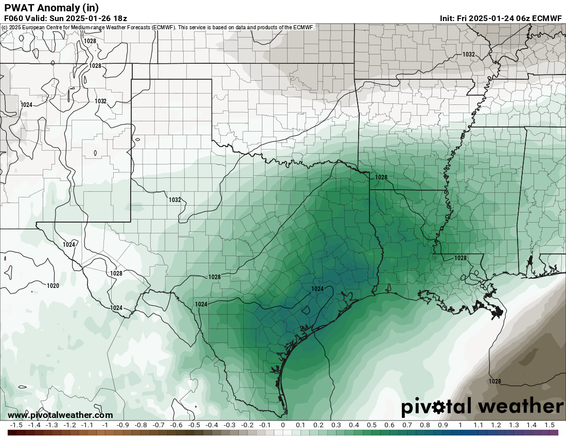
With the amount of atmospheric moisture well above average (almost 200 percent of normal) on Sunday, there will almost certainly be enough heavy rain in spots to produce localized street flooding. If you have plans on Sunday, just keep that in mind. A cool front will nudge offshore Monday, likely ending the rain chances by mid to late morning.
Sunday morning lows will not drop below 50 degrees. Then, we’ll see a range of temperatures Sunday afternoon, with highs near 60 or so in Huntsville to near 70 in Lake Jackson. Mid to upper-60s should dominate in the city. Monday’s front has minimal “oomph” behind it, so look for temperatures to only be a few degrees cooler Monday.
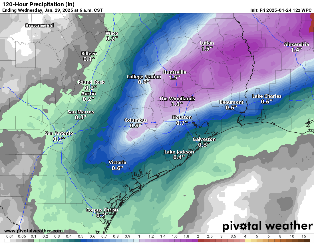
Look for rain totals to average a half-inch to an inch on Sunday and Monday, but it’s likely that some more localized spots see 2 to 4 inches of rain. This seems especially possible from northern Harris into Montgomery, Liberty, and Polk Counties, but it can’t be entirely ruled out elsewhere.
Rest of next week
I am assuming next week is going to feature a lot of continued clouds, so soak up the sun while we have it around. Isolated showers are possible Tuesday and Wednesday. There is growing consensus in modeling that a somewhat stronger cold front is going to push through later next week. This seems likely to feature another round or two of rain and thunder. The details are TBD, but it’s possible we double down on some heavy rain risk later next week. Stay tuned. Temps look mild next week, with highs in the 60s and lows in the 50s.

I don’t want a taste of spring. It’s still effin’ January.
Agreed
As of 0700 this morning, it is 27F at my house, per the PWS a few hundred yards away. Other PWSs near me are showing 25F to 29F. Average of them all is 28F. I hope this goes away soon!
I keep seeing blurbs about another potential arctic blast the first or second week of February. Is there anything to this, or is it just clickbait?
I saw that too…
mind sharing the source?
Did not hear or read about this on the news..Saw a mention about the potential February Arctic weather on my neighborhood page… Second hand information..If I see another post, I’ll ask about the source..
Check YouTube for videos from an organization BAM Weather. They said there is potential for more masses of cold polar air to come down into the lower 48 states. But they didn’t say it was guaranteed, just that a lot of factors lined up for the possibility. And it sounded like the possibility was greater for the northeast and southeast. They mentioned a time frame of Feb 5th to the 15th, if I recall correctly.
The end of todays post mentions colder weather next week, but TBD for details for now
Best to wait
Most likely click bait. We almost never see 2 true Arctic blasts in a season here in SE Texas.
Quote, “After 4 straight mornings with lows in the 20s, Houston officially failed to drop below 30 this morning as we continue to thaw out.”
Swing on up here to Magnolia, as we’re at 26 degrees at 7:50 this morning 🙂
This morning was probably our last freeze until next January
I have the feeling there will be another round of something cold & strong. Like two on tap.
If the atmospheric moisture level are going to be so high than why are the rainfall totals expected to be so low? Let me guess, the dreaded cap will return.
Lack of appropriate forcing mechanism? Simply the presence of moisture isn’t enough, otherwise we’d all drown in the summer here.
Does it seem like the ECMWF is better for predicting storms (& severity) from over land, while the GFS is better over the water?
I’m noticing an aspect of this snowfall which I’ve never noticed in any previous ones. It’s now 12:30pm Friday, the last snowflake fell around 11:00 or 11:30am on Tuesday and there’s still a patch of snow on a neighbor’s roof. I’ve never seen any snow linger quite this long, as far as I can remember anyway.
You know, that is weird & creepy – it hung around a long time, not wanting to melt, even though a lot of it was sun-exposed.
I kept looking on road cams, hoping it had cleared & kept seeing it cling. Maybe all the pollution/etc has chemically altered it a little. Slightly changed its melting point.
The refinery pollution around the Gulf has changed the hurricane canopies a little, spread them further & thinned them slightly when they come into contact w each other. Maybe it affects the snow as well?
That is because temperatures have stayed cold longer than usual after the snow this time. Usually when we get snow the temperatures warm up quite a bit two or three days later. Like highs in the 70s and lows in the 60s warm. This time we have had chilly days in the 40s and 50s with nights still dropping below freezing days after the snow fell.
The days have been chilly, but it’s snowed before here and not stuck like it has. Direct sun should have melted it, esp on the darker roofs.
Maybe it’s both the pollution and the chill.
Are you posting tomorrow regarding whether or not to do a SCW flood alert Sunday? When will we know about Thursday?