In brief: Expect more sunshine today, but then a stalled boundary will bring a healthy chance of rain showers into the region on Thursday and possibly Friday morning. If you’re tired of the rain, the good news is that we’ll then dry out for awhile. But now that we’re approaching late May, sunny weather means highs in the 90s, of which there will be plenty next week.
Before getting to the forecast, Matt and I want to say a quick note of congratulations to chief meteorologist Frank Billingsley, who is retiring next month after 30 years at KPRC-TV. He has worked at Channel 2 for as long as I have lived and worked in the Houston area (1997), and we have covered many of the same extreme weather events, including Hurricanes Harvey, Rita, and Ike, Tropical Storm Allison, and the great freeze in 2021. Frank has always been friendly and helpful, and we wish him nothing but the best.
Wednesday
If you liked Tuesday, you’re in luck, because today will bring more sunshine and (somewhat) drier air. Highs will again flirt with 90 degrees. However, with winds swinging around to come from the southeast, we’ll see an influx of more moist air this evening, with lows only dropping into the lower 70s.

Thursday
Did you miss the rain? Because it returns on Thursday and possibly Friday for a final engagement before exiting the area for awhile. I think we’ll see isolated to scattered showers on Thursday morning before more organized showers and thunderstorms arrive during the afternoon hours and persist into the evening or overnight hours. Once again, the most favored region for the heaviest rains will be north of Interstate 10, and likely in Montgomery County and points north. These inland areas should see 1 to 3 inches of rainfall, with higher bullseyes of 5 inches possible for some locations. Closer to the coast, south of Interstate 10, accumulations should be less. I’m most concerned about rivers, as flooding continues along the Trinity, East Fork of the San Jacinto, and lower Brazos basins.
Highs, otherwise, should be in the mid-80s with mostly cloudy skies. A fairly strong southeasterly breeze will be in place, with gusts up to 25 mph.
Friday
Another round of showers is possible on Friday morning before some probable clearing during the afternoon hours, with partly sunny skies. Highs will likely reach the mid- to upper-80s, depending on how much sun breaks through during the afternoon. Lows on Friday night will drop to around 70 degrees in Houston, give or take.
Saturday and Sunday
As high pressure takes hold, we have good confidence in an extended period of mostly sunny and warmer weather. Highs on Saturday are likely to reach about 90 degrees, with temperatures pushing into the lower 90s by Sunday. It will feel reasonably humid, with only a modest southerly wind.
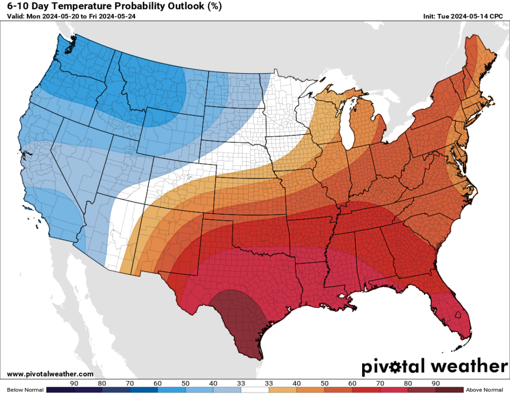
Next week
Expect mostly sunny days for most of next week, with highs generally in the low-90s—although some inland locations could push into the mid-90s. Rain chances look low to non-existent at least through the middle of next week. For all intents and purposes, summer starts next week. Hope you’re ready!

“ For all intents and purposes, summer starts next week.”
At least Mother Nature waited until the second half of May this year. I’ve seen worse!
Yes the May of 1996, 1998, 2003, 2018, and 2022 were definitely worse. This May has been excessively muggy though, thanks to the constant onshore winds and the hotter than normal gulf waters. I am jealous of the Pacific Northwest states right now.
Summer runs May 1 through October 31.
Give 13 or take 45 days for the beginning, vice versa for the end.
Farewell dry cool air; see you sometime in October….or until we meet again. The fond memories will sustain me through the long summer heat.
February to May of 2024 has seen average temperatures 3-4 degrees warmer than normal (according to the NOAA). Even so, the beginning of this year has felt pleasant to be outdoors. I’m curious if the summertime temperature will be higher or lower than normal this year.
It will depend on if we get stuck under high pressure or not. If we have multiple low pressure systems stall over the region, than this summer will be rainy and cooler like in 2007 and 2021. But regardless this summer will still likely be warmer than the 30 year average because the excessive water vapor release from the hotter than normal gulf will prevent nighttime temperatures from dropping as much as they used to. The best we can hope for these days is that we don’t see so many days over 100 degrees with heat index values over 110 like last summer.
Hasn’t really felt pleasant since mid February and the skimpy (short lived) cold fronts afterwards, why couldn’t we have 11 more January 2024s???
Couldn’t agree more!
I feel like we had some absolutely gorgeous weekends in March and the first half of April. Not cold, but cool and sunny and delightful.
I actually thought it felt fantastic this morning. Makes me ready for October again.
Felt great in the morning, noon…..
Dewpoints this weekend won’t be crazy high, so I think both Saturday and Sunday mornings have the potential to be somewhat pleasant.
I would love to understand why the rain and storms are always north of l10 lately. Is there something that stops it from pushing further down?
Right now there is an inversion (capping) due to the temperature of the water. Storms need cold air aloft to build height. The temperature gradient near the coast is not sufficient for storms to reach such heights.
Like Keith said there has been a cap blocking alot of the storms from developing further to the south, but we did get some ferocious storms on Monday down here along the coast which led to downed trees and power outages across Matagorda and Brazoria County including my house.
Crap… I hate summer….as much as I hate the winters in the north.
Well you have spring and fall to kinda enjoy?
Congratulations,Frank Billingsley!! I’ve been watching him since 1997!! My favorite meteorologist. Good luck on his retirement.👍
Worried about the potential for flight delays tomorrow afternoon. Scheduled to fly out of IAH and this may affect our travel plans 😫😫
As someone who commutes via bike, I really hope this summer isn’t as miserable as the last one (my first Houston summer). At least I’ll know what to expect this time around.