In brief: In today’s post we dive into the precipitation Houston recorded this summer. Most of the region got significantly less than normal, but we’re not in a drought. Why? We also dig into the forecast which indicates continued warm-to-hot temperatures and an increase in rain chances ahead.
Autumnal equinox looms
Alright, I’ll allow that it does not really feel like summer should be ending soon, especially with a 95-degree temperature reading at Bush Intercontinental Airport on Wednesday afternoon. And in reality, I am sorry to say, I don’t think we are done with heat just yet. Nevertheless, by next Monday we will come to the Autumnal equinox, which by some reckonings marks the beginning of fall in the Northern hemisphere. Note that we already passed into meteorological fall on September 1.
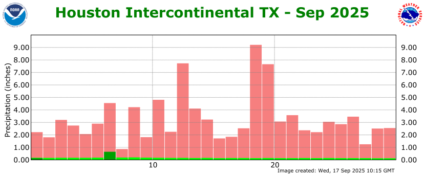
As I noted yesterday, we have had a fairly dry start to September. Since there is not a whole lot else to talk about today, and because the month so far has been dry-ish, I thought we might take a look at how the region did precipitation-wise over the course of the summer. As you can see in the map below, showing “percent of normal” rainfall over the last 90 days, the vast majority of the Houston region has received 50 to 90 percent of normal rainfall during the hottest part of the year.
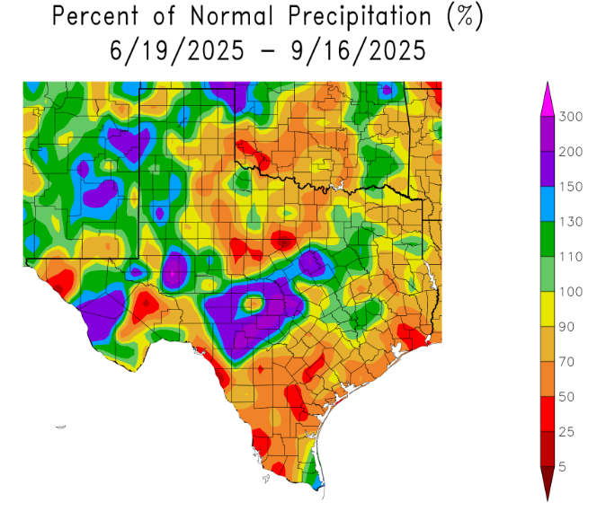
So why aren’t we in a drought? (Really, we are not). The answer is two-fold. We had some really nice rains in late spring that positioned our soils well for the summer months. And then, while conditions were drier than normal across Houston in July, August, and September, we did have periodic rains that brought a few inches at a time. So if you add that up, we’ve come through summer alright. Things have gotten fairly dry in parts of Houston in the last week, but I’m hopeful that we’ll see some decent rains next week to get us back on track.
Thursday
Yes, you can expect pretty much the same weather today that we’ve experienced for about the last 10 days: highs in the low-90s in central Houston, with slightly hotter temperatures further inland, and slightly cooler closer to the coast. Skies will be mostly sunny, with a slight chance of some showers and thunderstorms popping up this afternoon. Overnight lows will fall into the mid-70s.
Friday and Saturday
More of the same.
Sunday
By Sunday the pattern starts to become a little more unsettled, such that we might see rain chances of 20 to 40 percent by the afternoon. This may help to hold high temperatures down to about 90 degrees in Houston. If you have outdoor plans I don’t think these showers will prove to be too disruptive, as they should be scattered and brief.
Next week
Our pattern really should shift some next week, with better daily rain chances beginning by Monday. Overall accumulations next week will probably be on the order of 1 inch, but also there will likely be a great deal of variability in that. Modestly more clouds should keep highs on the order of 90 degrees, although rainier days may top out in the upper 80s. A weak front may back door its way into the region later next week, but that is far from certain.
