In brief: It is chilly across Houston this morning, with some outlying areas falling all the way into the upper 30s. Most of us are in the lower 40s. This is as cold we are going to get for awhile, and in fact a rather swift warm-up will begin 24 hours from now. We’ll then be unseasonably warm through the Christmas holiday.
A brief reminder that it’s winter
It is fairly chilly out there this morning. Some locations in Montgomery County, including the usual spots like Conroe, have fallen into the 30s and may be experiencing some frost. Most of the rest of the Houston metro area is in the 40s. Our weather is clear, and cool, and just about normal for this time of year when our days are the shortest.
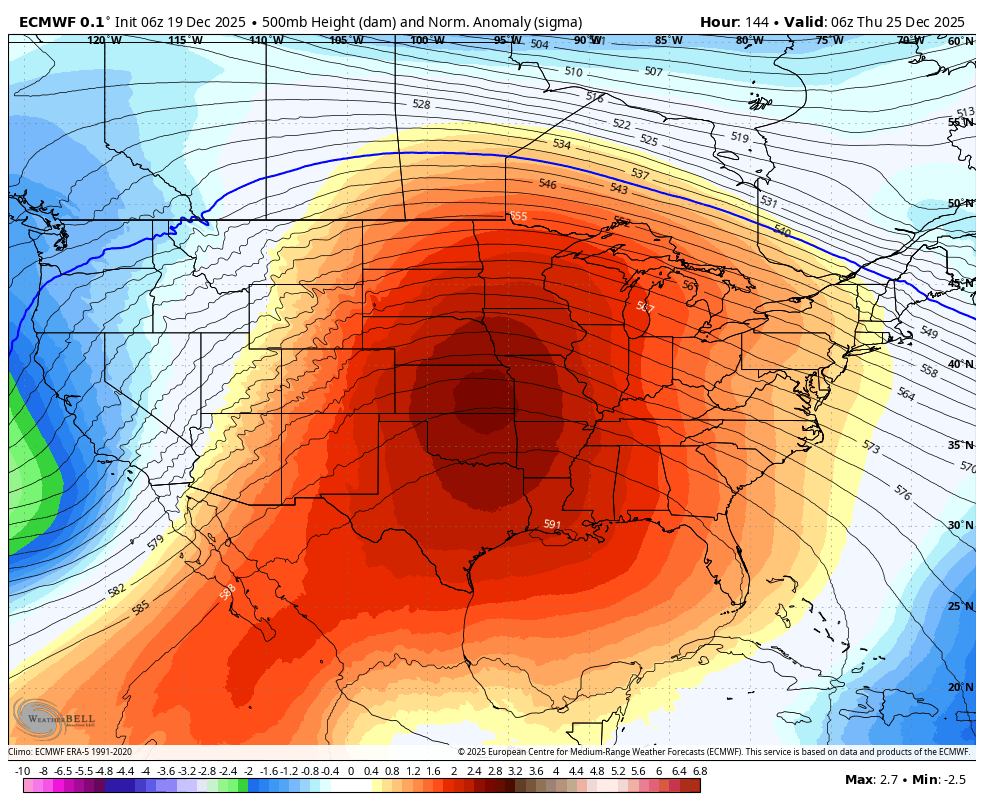
If you like winter (and I know many of you do not), make sure to spend a little time outside today. Because when you look at a forecast for the days ahead it is kind of wild. We are briefly cold, and then it’s at least a solid week of rather balmy weather, with highs near record maximum temperatures. I’d love to tell you it won’t be humid, but with dewpoints solidly in the mid-60s, it will be. And we are going to be prone to early morning fog, which I don’t think anyone likes. (If you do, explain yourself in the comments!)

On the upside, beyond the fog, there is very little to be concerned about. We aren’t going to have snow or icy roads, and there is no signal for any kind of severe weather. So while it won’t feel exactly festive out there, family gatherings should not be impacted by the weather. As a forecaster, selfishly, it also makes our job a bit easier during the holiday week when there are lots of activities with families and friends!
Friday
Today is really going to be a lovely winter day. Overnight winds have calmed down, and we’re going to have a sunny day with highs in the mid-60s. There is literally going to be nothing to complain about, although I know some readers will take that as a challenge. We are going to have one more passably chilly night, with lows in the upper 40s for most of the region. But with the onshore flow resuming on Friday night, we are going to warm up quickly on Saturday morning.
Saturday through Tuesday
After Saturday morning we’re going to see steady-eddie weather, with highs in the upper 70s to 80 degrees, a mix of sunshine and clouds, warm nights in the mid-60s, and a chance of morning fog. Rain chances will be close to zero each day. Really, I don’t expect much change from day to day, which is how it goes with potent high pressure systems like this.
Christmas Eve, Christmas Day, and Boxing Day
For those who don’t know, Boxing Day is December 26th, and celebrated in Canada and elsewhere in the Commonwealth nations. No one is quite sure why it’s called “Boxing” day, but it has nothing to do with fighting. And I thought I would call it out this year because there is a Canadian astronaut, Jeremy Hansen, flying on the Artemis II mission around the Moon early next year. He and his family have spent a lot of time in Houston, while he trains at NASA, and Jeremy is a swell fellow.
Anyway, I don’t expect much change in daytime temperatures during the second half of next week, but we could see a slight diminution in humidity, and this would allow for nighttime temperatures to drop by a couple of degrees. My prediction for Christmas Day remains the same as it’s been for more than a week now: Highs in the upper 70s, a decent amount of humidity, and partly sunny skies. Rain chances are very low. You can trade ugly sweaters for ugly sweating, if you like.
Is it ever going to feel like winter again?
Yes. Most of our trusted models show a significant pattern change around Sunday, Dec. 28, or Monday, Jan. 29. Since that is at the edge of predictability, we should take it with a grain of salt. But I remain hopeful that winter will eventually start to feel like winter again.
Since the forecast is pretty well locked in we’re going to take a full weekend off here. See you on Monday!
