In brief: Steel thyself, for today is likely to be the hottest day of 2025 so far. But the upside of this is that the region will see about 24 hours of modestly drier air starting late this afternoon or evening. Looking ahead to Memorial Day weekend, a chance of rain returns Sunday and especially Monday.
Tuesday
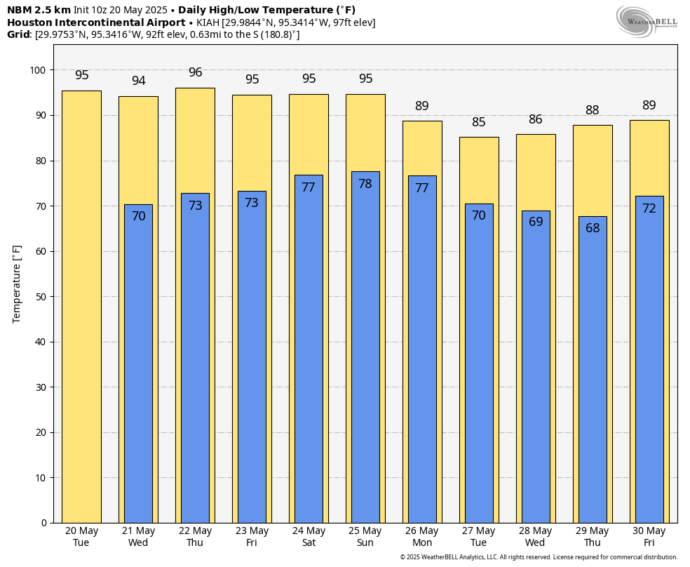
The city of Houston recorded its hottest day of the year last Wednesday, when the mercury hit 96 degrees at Bush Intercontinental Airport. Today, in advance of a weak front, we may go a tick or two higher. This is because of a pronounced warm, southwesterly flow in the atmosphere, and front that will be compressing air as it moves toward the region. Much of the city away from the coast will push into the mid- to upper-90s, and with sticky dewpoints in the 70s it’s going to feel like August outside. This seems really, really unfair for May, doesn’t it?
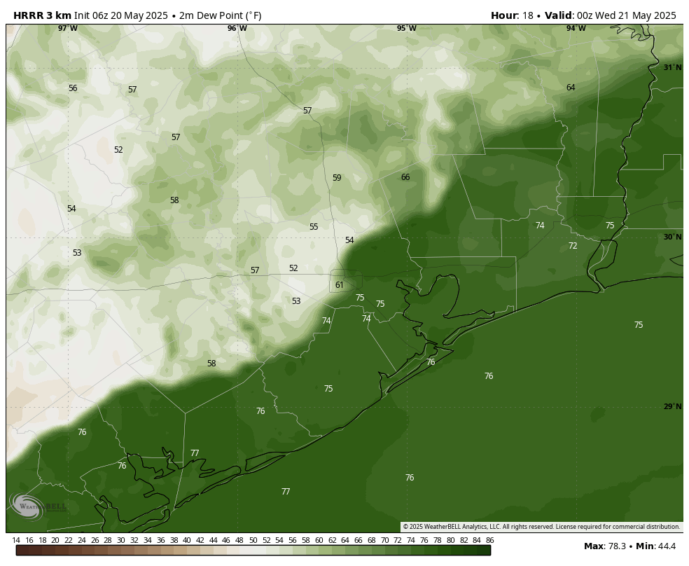
Well yes, it does. Fortunately, a weak front is going to slowly slide into the area this afternoon and evening. It may bring a few brief, scattered showers and thunderstorms with it. By around sunset this evening, areas inland of Highway 59/Interstate 69 should see dewpoints in the 50s. Air temperatures will still be warmish, for sure, but at least humidity will drop some. It probably won’t be until after midnight, or a few hours after, before these somewhat lower dewpoints drop all the way to the coast. With the drier air, low temperatures tonight probably will fall into the upper 60s for areas inland of Interstate 10, while being a bit warmer closer to the coast.
Wednesday
Don’t blink or you’ll miss the drier air. South of I-10 dewpoints will start climbing by Wednesday afternoon, and the humidity will spread inland everywhere by Wednesday evening. With the daytime sunshine, I expect highs to still reach the mid-90s on Wednesday with light northeast winds turning southeast. Lows drop to the low- to mid- 70s overnight.
Thursday
This should be a hot and partly sunny day, with temperatures in the mid-90s. I expect to see somewhat of a disturbed atmosphere aloft, and this normally might contribute to a chance of showers. However, this upper air will have to overcome a capping inversion, and for this reason I am going to limit rain chances to about 20 percent, and that is probably only for areas south of Interstate 10. Lows on Thursday night will drop into the 70s.
Friday
This should be a sunny, hot, and humid day with temperatures in the mid-90s.
Memorial Day weekend
The first third of the holiday weekend probably will see a continuation of Friday’s weather, but the forecast turns a bit more interesting later on. The combination of a weakening ridge of high pressure and a somewhat disturbed atmosphere may bring a slight chance of showers and thunderstorms into the region on Sunday, with better chances still on Memorial Day, perhaps 50 percent or higher Daytime highs should be cooler, perhaps in the lower 90s.
Next week
A wetter and somewhat cooler pattern should settle in next week. Probably we will see more May-like temperatures in the upper 80s, with a daily chance of showers and thunderstorms. We’ll see. Almost anything will be better than today’s August in May.

The sad thing is that this is the new normal for May now. It’s not just a fluke anymore, and the progressively warming Gulf is making it worse by excess evaporation, raising dew point levels. We did not used to have weeks in a row of dew points in the upper 70s and morning low temperatures in the upper 70s to low 80s in May before. Not to mention 2 weeks in a row of highs in the mid to upper 90s. Sure, we’ve had a few early season heatwaves similar to this in May before in the past, but not this intense or prolonged.
Very well said. I’ve lived here over 50 years and walk 8-10 miles five mornings a week. Without a doubt this May is the warmest and with the highest dewpoints I’ve ever felt this early in the year. Heat indices early in the morning have been 85-88!
The first 14 days of May were glorious. Since then it’s been a little warm…
The lack of rain is concerning to me. I stepped out this morning and the sky was so dark and primed for a thunderstorm but nothing happened. It’s like the atmosphere is extremely constipated.
Dina: It appears that there is a cap in place over Houston. Earlier this morning there were two severe thunderstorms south of and near San Antonio and some more rain south of Columbus. That is all pretty much gone now.
Todays post references cap inversion affecting rain chances Thursday
It’s actually warm air inversion. The term “cap” makes it seem like…rigid. Would be neat if Eric put up a simplified skewed T diagram. Readers would see the dew point curve vs the temperature curve at progressive elevation. It becomes clear then – temperature never reaches dew point….ergo no rain. Especially if temperature gets warmer at height. There’s no rule against that! Everybody complaining about the urban heat island …that actually ought to help relieve warm air inversion.
The current Dew point in Bay City is 81. The heat index is 104 with an air temp of only 87. This is not normal at all for mid-May. This is just more evidence that the Gulf is significantly warmer than normal for this time of year. The gulf has been warmer than normal for a long time, and it is being caused by two words that spark very heated debates, so I won’t even mention them.
The odd thing is that speaking to young people they seem to be oblivious to the issues with climate change and yet they are the people who will be more affected than we are now. It’s like the proverbial lobster in the pot who do not realize its peril until the water starts boiling.
As for the ‘heated debate’, if we don’t acknowledge the problem and act upon it, the future will be a difficult road to travel.
That’s why I think arguing about it is pointless because it IS happening. Focus should be on coming up with ways to, as you said, acknowledge and act as much as we can. I wonder sometimes about how all of this affects places such as Saudi Arabia, which holds the all time heat index record of 178°F, and how much worse it may get there.
Or 180°F in Iran, whichever it is.
Sure wish people wouldn’t use hatter in their non de plume. Like Summhat. Disturbing. But 40 years and many, many $billions later we have cleaned the air. A lot of work and visible payback. No smog like before. More sunlight gets thru. So before we “act” let’s see if the warming curve flattens.
I don’t mean it in a hateful or rude way, I’m just strongly emphasizing my dislike for the summer season primarily in SE Texas in my name, lol. You bring up a good point about the air pollution thing, though. The sharp reduction in pollution has infact contributed to some of the warming. That is a scientific fact, but it is not the only thing. There may still be a slog of excess water vapor still left in the atmosphere after the Hunga Tonga eruption back in 2022.
Unfortunately, the elephant in the room still seems to be our excess greenhouse gasses. Hopefully, some kind of curve happens soon. Warmer oceans can cause more cloud cover, which reflects the sunlight, preventing daytime temperatures from warming as much. Maybe that will lead to some kind of leveling out in the coming years. One can dream can’t they? 🤞🤞
I like your name. It’s honest 🙂