In brief: Houston will remain warm and humid through next weekend, with partly to mostly sunny days and highs generally in the low 90s. Rain chances are low throughout the period. Today’s post also addresses some lingering questions from last week’s storms, including why the event was not particularly well predicted.
Over the weekend, the greater Houston region continued to recover from damaging winds last Thursday. On Sunday evening, CenterPoint said that it had restored electricity to more than 700,000 people who lost power, with about 240,000 customers still without. The transmission company said it remains on track to be “substantially complete” with power restoration by Wednesday evening. Before jumping into the forecast here are some additional thoughts about the very strong storms that arrived last week.
Why wasn’t this well predicted?
This is a great question. The answer is that we have seen these kinds of setups before in which there is an atmosphere primed with moisture and instability, and with a potential trigger for supercell storms to form many times before. However, even hours before their development just west of Houston on Thursday, there was no ready data to indicate the true severity of the blow-the-doors-off storm that was coming.
It’s the kind of thing where there maybe is a 1-in-50 or a 1-in-100 chance that something so severe, a supercell event with very strong straight-line winds directly over the city’s urban core, could develop. If we had messaged that an “extremely dangerous and destructive event” was coming the previous 10 times there was such an atmospheric setup, and nothing of any real significance happened, who would believe us on the 11th time? There is a boy-who-cried-wolf problem here. The only real solution here is that we try harder to find that bit of data that gives us more confidence in a rare event like this one. I’m confident that Thursday’s storms will be studied in depth to identify such clues.
I was lying in bed on Sunday morning thinking about all of this—yes, I lose sleep worrying about this kind of stuff—and of all things a 2002 Houston Texans football game popped into mind. It was December 8, the team’s first season, and being an expansion franchise the Texans were not great. That week the Texans had to go to Pittsburgh and play the Steelers in near-freezing temperatures for a meaningless game. The Steelers were a decent football team, nothing fantastic, but were expected to blow the Texans out. The line was Steelers -14. The Steelers outgained the Texans 442 yards to 47. They won the time of possession with 40 minutes to 20 minutes. Texans quarterback David Carr was 3-of-10 passing, for 33 yards. That was in line with expectations.
But the Texans won 24 to 6. They returned three turnovers for touchdowns, and kicked a field goal after a short drive. The Steelers had many more penalties. Their two long drives ended in field goals rather than touchdowns. It was just an odd day. While the final score was within the bound of possibilities, on any given Sunday anything can happen when two teams meet, it was the lowest probability event. That’s kind of like what happened Thursday. A super-storm was within the realms of possibility, but was like an expansion team playing terribly, but still blowing out the Pittsburgh Steelers on the road in very cold conditions.
Why weren’t there more real-time warnings?
This is something Matt and I are taking away from the storms. I feel like we do a good job of forecasting the weather here, but where we struggle is in real-time coverage. Some readers have asked why we did not send out warnings for tornadoes on Thursday. That is because this is the express function of the National Weather Service, which has a large staff and the technology to send out real time warnings for tornadoes and other life-threatening weather events. Here’s more information about the agency’s wireless emergency alerts program. They are the experts at that, and we defer to them.
Matt and I were both tracking Thursday’s storm in real time. We were on top of things. And there was perhaps a 30 to 60-minute window between 5:30 and 6:30 p.m. when we could have provided some actionable information. However, in the time it would take to write and disseminate a post about that in real-time, the dynamic event might have already passed for most people. One possible solution is that we are likely to start sending (albeit very rarely) “urgent notifications” through our app. It is available for free here for Apple ioS, and here for Android. Regardless, we recognize this as a weakness and will address it here at Space City Weather. For one thing, we are changing the frequency of updates on days when severe weather is possible.
Monday
Our overall warm, but not extremely hot pattern will continue as we inch toward the end of May. With high pressure largely in control we’ll see this pattern largely persist through the holiday weekend, with the only really noticeable change in the strength of southerly winds, or a few more clouds on some days. For today, we’ll see highs generally in the low 90s, with only coastal areas unlikely to reach 90 degrees. Skies will be mostly sunny. Winds will blow from the southeast at 5 to 10 mph. Overnight lows will be warmer than we’ve seen, dropping only into the upper 70s.
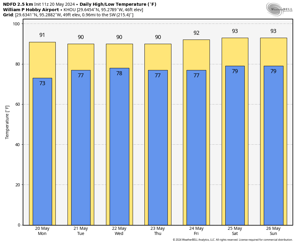
Tuesday and Wednesday
In response to low pressure over the central United States, we’ll see an uptick in southerly winds with gusts up to 25 mph. Both days will see partly to sunny skies, with highs around 90 degrees. Nights remain quite warm.
Thursday and Friday
These will be partly to mostly sunny days, with winds perhaps slackening a bit. Highs in the low 90s. There is perhaps a 10 percent chance of rain showers each afternoon.
Saturday, Sunday, and Monday
Memorial Day weekend looks warm and sunny. Expect highs in the low 90s, with warm nights. Rain chances remain near nil. Plan your outdoor activities with confidence.
Next week
There are some hints of a pattern change by Tuesday or Wednesday of next week, with possibly a weak front sneaking into the area at the end of the month, and bringing with it a smattering of rain chances. This is far enough into the forecast, however, that my overall confidence is quite low. We shall see.

Eric and Matt- your rational, fact based, unhyped forecasts and guidance are highly appreciated. You are the go-to source for all things weather. Keep up the good work!
I’m a huge SpaceCityWx fan and rely on you for all the detailed, no hype forecasts and retrospective analyses, especially of big events. But I think there’s a downside for you to try also to fill the minute-to-minute urgent warning space. That really is the NWS’s wheelhouse, and I think there’s more risk if people think they can get every aspect of weather info here than if it’s clear that you don’t do the urgent-warning function. Maybe there’s a compromise where your sites can auto-repeat the NWS warnings/feeds?
This is what I was thinking, too. Eric and Matt are excellent but at the end of the day they’re two guys with lives to live and other professional responsibilities. They can’t replace the NWS for up-to-the-minute urgent weather warnings, and there is some danger in having people expect that or use SCW as their ONLY information source. If they can figure out the technicalities of auto-relaying NWS warnings on their app and website, that might be a really good idea. Otherwise, maybe they can recommend what people need to download/ monitor on their phones to make sure they are getting urgent warnings.
same. I think you guys are taking on a responsibility you shouldn’t have to, based on the complaints from a particularly whiny minority of people who are just looking for someone to blame, and wouldn’t heed emergency warnings anyway, no matter who provides them.
These people may be unnecessarily litigious as well (and probably are). Include a lot of hefty disclaimers if you do decide to try to be emergency notice providers…
Eric thanks for the heart felt recap on Thursday storm. For me you guys are right where I need for the forecasting and awareness then I rely on the NWS and the City of Houston alert system which repeats the NWS alerts. So Thursday for me developed as expected because of the great job you and others do. Thanks again
I’ll the the 1/50 chance and appreciate the no nonsense reporting. I use this to make decisions about business, staffing, and safety and the no hype forecasting has been a huge asset over my last 8 years in Houston. Freak events happen and I’m not sure how much difference an extra post would have made when our devices were all screeching with Tornado warnings already.
Thanks guys. Keep up the great reporting.
Eric & Matt,
Don’t beat yourself up so bad. Y’all do a great job in what you are trying to do. You can’t be everything to everybody. Remain focused on what y’all do best. And thanks for being there.
Joe
Thanks so much for the recap. I was reflecting on this as well. We so often get tornado warnings and nothing happens. I think it would be super helpful for it to be Quantified like you did. 1/100 Chance of severity. So we can make our own informed decisions. I understand that a tornado warning is simpler for people… every time I get one, I have to watch versus warning. And the warning areas are always so ginormous. I can never tell if they apply to my area or not either. Not sure if any of that is actionable for you or helpful. Hope all is well thanks for your work
Rotation as depicted on radar does not always equal a tornado on the ground. Unless there’s eyes out there at those locations, the best that can be done is to issue warnings based on radar evidence. Once there are confirmed spotter reports or debris indications (correlation coefficient) on radar, then things can be a bit more exact. Tornadoes frequently take aberrant paths and, sometimes, what are called “deviant” paths. In this regard the warning boxes are often funnel-shaped to try to account for where a tornado may go. A few minutes extra in a closet or central portion of the home is typically not going to significantly impact personal lives.
So the warnings are usually pretty specific about where the possible tornado is, if you read the whole warning. Why do you have trouble determining if it is in your area or not? Is it a lack of familiarity with the different parts of the metro area? I don’t usually find it difficult to tell if it’s close to me or not. Genuinely asking, I’m not trying to be a jerk.
Keep up the great work! Also appreciate your self-evaluation and continuing efforts to improve.
We continue to appreciate your excellent weather information and consider this an anomaly and one that you obviously didn’t have adequate data to do an early prediction. Appreciate, as above, your continuing search for perfection in weather predictions!!!
Two weather events in the same number of weeks that were very difficult to predict. You guys do the best you possibly can do and I’m positive most of the city gets their weather news from you folks. And we all trust you…keep up the good work. One or two instances does not degrade the amazing work you do for this city!
I don’t think providing up to the minute severe weather or tornado warnings is something you should spend too much time on. I know personally I visit this page for an overview of expected weather for they day and week. A simple severe weather/tornado is possible today keep your eye to the sky and radar app kind of forecast. SCW did a great job forecasting the possibility of severe weather each and every time it happened over the last few weeks. The intensity and timing of these quickly changing events is just not possible with any accuracy for any forecaster. A simple “the potential exists for severe weather” is all you should worry about forecasting.
Not sure this is allowed here but I thought folks might be interested — this is the fundraiser to contribute to the young family who lost their mother to a falling tree branch on Thursday: https://www.gofundme.com/f/please-help-support-the-martinez-family?utm_campaign=p_cp+share-sheet&utm_medium=copy_link_all&utm_source=customer
I work at a golf course and am a total weathernurd. I have no less than 7 different apps on my phone. I obviously follow you guys on a very regular basis (Jim Cantore is still my hero for reporting on Ike). You guys do a fantastic job keeping us informed. There is absolutely no one foresaw what happened. PLEASE keep up the great service you provide.
You guys do a great job. Please don’t forget that. You are deeply appreciated.
You guys do a really good job, and it’s helpful to read the daily updates. Like anything else, explaining the limitations of what you know and what you can or can’t do is valuable, especially in today’s media environment where you have a lot of people that commonly overstate what they know.
Y’all do a great job keeping us all up on the weather. My physics knowledge is seriously rudimentary, but I understand enough to know that there are a lot of variables, so that there are opportunities for many different outcomes when it comes to weather events. I rely on your forecasts for no-hype weather reporting that’s in clear language for us wanna-be science nerds.
You guys do a great job. You are my #1 choice to go to for weather information.
Keep up the fantastic job that you do in keeping us all updated on our at times very unpredictable weather!
You guys do a fantastic job! I don’t know if you’ve been inundated with criticism, but I hope not. Like you said, there are plenty of apps that can give real-time warnings. I appreciate both your long-term and short-term forecasts, as well as the explanations you offer on various weather events. Keep up the good work!
I will just reiterate what everyone else has said and say that you guys do an excellent job, and are the only local weather source I trust. If I need emergency info, I will also go to the NWS. I like your no-nonsense and in-depth info and will continue to rely on you for that. Increased frequency would be great, but I’ll take what I can get. Thank you for the continued work!
Agree with many others. That sweeping tail of red orange radar heading toward the URBAN CORE looked like many others that have passed by without incident. I got plenty of other tornado warnings well in front of the radar. My emergency weather notifications with shrill tone went off well in time. For sure would have woken me in time if late at night. Please spend your energy searching for the nugget that made this different, and do not dwell too much about this comment section. It’s where we like to vent about witty weather. Take care of your psyche
I had not intended to make a comment, but this: “Why weren’t there more real-time warnings?”
What difference would it have made? Would people have paid any attention, do people driving down a highway slow when they see a disabled vehicle ahead, or pay heed to any warning signs – or even belive we, mankind, actually are causing the planet to overeat. ? No, of course not. Idiocy is one of the prime indicators of human nature.
So, don’t beat yourselves up, Matt and Eric, there is little you could have done to ameliorate the effects of the storm.
An additional message would not have changed the final outcome. We all need to take individual responsibility to be weather-aware. Angry sky’s, we know the potential of severe storms, take cover to protect yourself and your family. Prediction is an imperfect science, leave NWS to do its work, and the rest of us, eye on the shy. Appreciate SCW’s in depth analysis and efforts to educate the public on the complexities of atmospheric science and hazards prediction. Keep up the good work guys!
100!
When will the storms of the past week be “named”? It seems like lesser storms are given names, at least by the national media, and this one resulting in at least seven deaths seems to “qualify”, whatever qualifies as such. We will all be referring to this storm for years to come as what?
The storm lasted 30 minutes. While it sucked and the impacts last much longer, there is no need to name it. It was a storm cell in a larger system. Locally, we will call it the May Derecho, just like DP residents call the 2023 tornado the January tornado or the Meyerland residents call floods The Tax Day flood/Memorial Day Flood. Hurricanes and Blizzards are probably named because they are usually tracked for days before so it’s easier to discuss them, especially if there are multiple storms being watched.
Houston really has had a near decade of extreme weather 🙁
Y’all are fantastic! I don’t think there’s anything you could have done to change the outcome. This was a rare storm and I love your explanations and in-depth analysis of it. The weather is the weather and sometimes impossible to predict. I lived in Tulsa for a long time and, believe me, there were times when severe storms (tornadoes) came in that weren’t predicted. People should know, severe weather, keep your eyes on the skies and pay attention!! Thank you for all you do!!
“If you’re taking flak, you’re over the target.”
Please don’t beat yourselves up.
Every source listed that day to stay Weather Aware/PDS – esp ~3pm onward.
SCW has set a high internal standard.
So high, your audience of (newer) followers complains when their unrealistic expectations are not being met and that you should deliver instantaneous content at the level of NWS, NOAA, AMS, Centerpoint ..combined.
Perhaps there are things to be done that would, perhaps, extend the utility of SCW for such emergencies. But I also know it will mean effort, costs and time to possibly do so.
Should you undertake those tasks, the irony will be that you will set an even higher level of expectations from certain sectors of your audience.
I hope everyone out there has power asap.
.
Matt – flaunt those degrees (iykyk)
I’m gonna be the devils advocate here and say SCW should’ve given a tornado warning or at the very least a damaging wind warning. Berger says by the time it takes to write it up, the event would probably be over. Well it took some time for the line of storms to traverse the entire area. And how long does it take to write a few sentences? No it doesn’t take the place of a good weather app with warnings. But even if it would’ve made the difference in some peoples lives and not the majority then they tried. Lanza is constantly on X so maybe he could’ve done it? I don’t rely on SCW exclusively, but some people do. At least Berger acknowledges this mornings post they’ll do better in the future.
The tornado warning for Harris County was issued around 6pm. As a Cypress resident, the tornado hit us around 6:10. I doubt a blog post would have reached us in time. Frankly, I simply think people shouldn’t only rely on SCW. At the very least, they should pay attention to the emergency alerts from the NWS.
Totally agree with relying on SCW only. The Weather Channel app notifications were going off crazy on my phone. But the huge winds extended all the way into Baytown. More than enough time to get a notification out from them. Even if only half or less of the subscribers read them, you made the difference with some people. There can never be enough information in a severe weather event imo. We read mountains of posts from SCW when the weather is benign. The real test is when it’s not. Everyone learns from this and we move on.
I sincerely appreciate all of your hard work. I think the fact that you obsess about (and explain) the variances, and are honest in your assessment of what else is possible, exemplifies your professionalism and your commitment to the community, so thank you. I agree that RT updates should be the purview of the appropriate authorities (NWS, HCOEM, etc.) and my suggestion is for the focus of the site to be on forecasts, and updates to said forecasts when things are unexpectedly about to hit the fan. Thanks again for all you guys do and here’s to hoping that we have an absolutely b-o-r-i-n-g summer, weather-wise.
I concur with many of the other voices here. You guys are awesome at what you do, and we thank and love you for it.
There’s no need for you to shoulder the burden of trying to provide minute-by-minute emergency warnings, and in my opinion that would be counter-productive. Make it clear how to get such alerts from existing sources and let people know when to be weather-aware.
I got very lucky on the south side of town, but my office and coworkers were not so lucky – definitely a BIG wake-up call for many, and a good kick in the butt to get the 3-5 day stock of supplies up dated and grab a generator soon, but not before those who are still going through this mess get one.
These storm outbreaks are excellent examples of nonlinear dynamics (aka the butterfly effect). And I feel for you guys when some butterfly decides to go rogue and set a severe storm in motion. Nearly all of us know the two of you do your best to stay on top of things. Keep it up!
I really appreciate you guys and how truthful and real you are with us (Unlike the TV sations, which borderlined on being absolutely ridiculous on Thursday). You guys told us what you knew and how it might work. So it didn’t go as we all thought. That is why call it forecasting, not dead solid facting. You guys are great at what you do and the great ones are always hard on themselves because they want to get better. I am praying for everyone who was impacted by the storm that they will be okay. You guys keep up the good work. It is greatly appreciated! Have a great week!
Sincerely
Chris Lovelace
How were the stations ridiculous? I watched Travis on 13 as the storm unfolded. He wasn’t bouncing from the walls. Just clear, direct information. Specifically get into an interior room. There’s this fallacy about SCW being the only one that doesn’t hype, and that is what is ridiculous.
Have to agree with this. I like the KHOU weather team, specifically David Paul. He’s the one I was watching during the storm and I like him because he’s never sensationalist and always puts me at ease. He also explains a lot of the meteorology in detail, much like the guys here at SCW do.
Well, the humidity us in full force! I’ve had to do some work outside and heat stroke is just around the corner.
What I have wondered is this. Part of weather prediction is physical modeling, and part is statistical modeling based on past experiences. But is the statistical part becoming less reliable because climate change is altering the baseline?
I’ve been coming to your website for a while now, and I know many others who do too. It’s very much appreciated that you follow the no hype approach because on the rare occasions when you do tell us to be on high alert we can trust that it’s accurate. I was in Cypress that afternoon visiting a friend and headed home early because in your morning forecast you mentioned the potential for severe storms later that day. Regardless of whether or not you provided real time updates, you still gave me enough information to know I needed to get myself home before the storm came. I received real time warnings on my phone and I have a radar app that I was checking. You’re not my only source of information, although you are preferred over others. Anyway, keep up the good work and thank you as always for the in depth explanations.
Eric and Matt, Don’t beat yourself up……I can do that for you!!!!!!
|!:~D}
Just going to give my experience with the storm and the weather messaging from a self-proclaimed local weather enthusiast.
Woke up and checked the weather like I always do. Saw there was some potential for disruptive activity in the afternoon. Went to work early and left early to stay off the roads just in case (lucky that my work affords me that flexibility to WFH when needed). Go to the bar after work knowing there was potential for weather, thought it might be nice to have a drink on the patio if it rained. Generally chit chat, talk about the weather with the locals, etc. starts to feel eerily calm outside.
Alerts start going off on peoples phones. I actually read it, most people assume its an Amber alert and ignore it. I see phrases like “DESTRUCTIVE WINDS” and “SEEK SHELTER IMMEDIATELY” so I let the patio know and am generally met with “bah, they can’t predict the weather for !@#$%” type of responses. I head inside. 15 minutes later and the patio is ripped apart and everyone is inside freaking out.
My take away is that most people are generally pretty weather ignorant, and that messaging doesn’t make it through very well. When the NWS speaks, people need to LISTEN! Forecasting has come so far lately!
LOVE the work y’all do. Don’t really consider it a miss if most people just aren’t interested. H-Town til we drown!
Part of this is all of the “did my own research/I know better” crowd. They can’t be bothered, or reached, with stuff like this and will then complain after they’ve suffered the consequences. These same people fail to heed warnings during tropical storm season.
Don’t listen to the haters! Yall are amazing 👏 thank you for all you do.
You folks are going way to easy here. Something is amiss with the modeling when it fails to predict such discordant events. This is life threatening weather here folks. Not like missing an afternoon shower. One can’t blame the forecaster but hopefully these folks are doing a post-mortem trying to figure out what’s missing.
To me, the news stations who often hype severe weather when the radar shows just green or yellow have caused us to become immune to actual threats like last week. I knew you’d said there would be weather, but wasn’t expecting the Derecho! When the tornado warning went off, I knew there was something very wrong for that doesn’t often happen. I wouldn’t likely have checked SCW when the warning went off; rather, I would have gone to the NWS, so I agree with others that you shouldn’t take on that burden. Maybe retweet the NWS or do a live Insta story if you see something forming?
That said, I continue to be opposed to your use of the phrase “north of I10”. To me, it is misleading because you often mean well north of Houston like College Station, Livingston, Lufkin, Huntsville, etc. This phrasing makes me dismiss your weather warnings because you so often say “north of I10” when the threat is ~50 miles north of I10.
I encourage you guys to reconsider how you pinpoint areas. Our coverage area is too big to simply lump us all into “north” or “south” of I10. I live in the Heights which is north of I10 but I find you often really mean north of the Beltway or Montgomery County or Grimes County when you say that. I don’t know what to believe because of the broad reference to “north of I10”. I really hope you’ll consider being more specific in your forecasts going forward; like “The Woodlands and points north” or the specific counties perhaps? It would be so much more helpful.
Thank you for your work!
We watched channel 2 just prior to the storm. They did a wonderful and accurate job as the weather unfolded.
I think your perception of this is skewed. I live in the most southeastern edge of Cypress (really between Cypress and Jersey Village) and I often find that their “north of I-10” warnings apply to my area. I may be north of the Heights, but I am well south of Montgomery or Grimes County, or the Woodlands. I’m about 10 miles north of I-10. If they actually meant “north of Harris County” they would probably say that. I guess what I’m saying is, “north of I-10” may sometimes apply to you and sometimes may not. Just like “isolated showers” may apply to you and may not. Common sense would say that the closer you are to I-10, the more 50/50 the chance, and that’s just something you should take into consideration.
Is it time Houston invests in tornado sirens? There’s a large population that doesn’t get cellular based alerts, and with the worsening weather, maybe it’s time we push for this.
You do a terrific job. And, I don’t turn to SCW for “real time alerts.” That is, indeed, the job of the NWS to disseminate that information. I look to you for accurate, no-hype, forecasts and that’s what I always get. I understand your desire to provide some additional “background” information (updates once or twice during the day or over the weekend). There are plenty of outlets that can alert and tell people what to do.
I also see discussion in here about sirens. I used to work in emergency management. They don’t work. No one knows what to do when it blows. Go inside? Get outside? What’s the threat? I got a ton of alerts through my cel phone, even after the power went out Thursday night. That’s sufficient.
I saw it coming from Giddings. My go to is tornadohq.com!! Excellent!! Turned on weather channel and they said the storms were moving east at 50 plus!! Yikes! Not good! Started panicking. Then Waller, then Hockley!! Ran to closet because I live just due east by 10 miles in Cypress .Horrific howling! I have lived through 3 tornadoes on the ground but… in a storm shelter. God spared me once again. Prayers to all and pay attention to wind speed, that helps.👍
I am always very entertained reading all this info. Find it fascinating.
I was actively following Matt on Twitter (not giving in) and while I was also tracking the tornado warning as it moved from Hempstead to Waller to Hockley, it was Matt’s tweet that had me grabbing the dogs and heading to the closet under our stairs.
“Possible tornado continues now toward Bridgeland, Towne Lake, and Copperfield. Be in shelter! (558P)”
Reading those words and then seeing the image of the radar and an arrow directly over my house in Bridgeland did more for me than any NWS alert ever could.
So, when questioning what you could have done differently, know that what was done was enough for some of us. I couldn’t be more thankful for the coverage both of you provide. Thank you for saving us from something much worse!!