In brief: In today’s post we discuss the best tool we have for determining “heat” during the summer time months, something called the wet bulb globe temperature. And we’re going to need this tool for the weekend, when air temperatures should spike into the upper 90s. Next week looks significantly cooler and wetter.
Let’s talk about heat, and how we measure it
We are getting toward the spiky bit of summer—although to be clear, summer does not typically peak in Houston until late July and the first part of August—so I want to talk about heat. Air temperature is one factor in how “hot” it feels outside, certainly the most important. But other factors such as dewpoints (which indicate humidity, and are guaranteed to be high this time of year), winds, cloud cover, and Sun angle also matter as well. The most comprehensive measurement of all these factors is something known as “wet bulb globe temperature.”
That’s a funky sounding, non-intuitive name, but basically it means the heat stress you will feel when stepping outside into the sunshine at any given point in time. Matt and I feel as though this is the best tool for a “quick glance” at how truly hot our weather will be in the next several days, and when care should be taken for extreme conditions. So in the coming weeks and months we will occasionally be sharing the graphic below to indicate how hot the coming days will be. As you can see, our region’s heat will crescendo this weekend before backing down early next week.
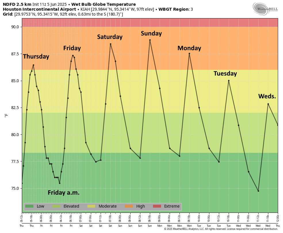
Thursday
Today won’t be super hot because we’ve got a chance for some lingering showers (perhaps 20 percent), and high pressure has yet to fully assert itself over the region. So expect high temperatures generally in the lower 90s, to go along with mostly sunny skies later today. Expect light winds, from the southwest, at 5 to 10 mph. Lows tonight will drop into the upper 70s.
Friday
This will be another day of temperatures in the low 90s with mostly sunny skies. We should also start to see the onset of hazier skies, as Saharan dust moves into the area after riding the trade winds all the way across the Atlantic Ocean. This will be a nuisance for people sensitive to air quality, but for most of us it will just dim the brilliance of sky a bit, and make our sunsets more reddish. Expect another warm night Friday.
Saturday and Sunday
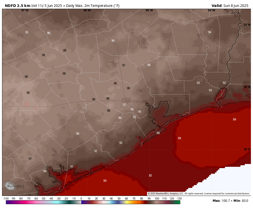
Temperatures will peak this weekend, with highs in the mid-90s on Saturday for most locations, and pushing well into the upper 90s on Sunday. It remains to be seen whether the haze shaves a degree or two off the top end of these highs, but all the same it’s going to be stinging hot outside. We are also near the point of the year when the Sun reaches the highest point in the sky, so please protect your skin if you’re going to be outside between about 10 am and 4 pm.
Next week
High pressure starts to retreat next week, opening us up to a more unsettled pattern. By Tuesday or so this should bring us cloudy skies and cooler weather (highs in the upper 80s are possible). Rain chances will also be on the upswing Tuesday, with healthy chances daily for showers and thunderstorms. It’s too early to have much confidence in rain totals, but I expect much of the region to get a good soaking, with the usual threat of some street flooding with summertime rains. If you have outdoor plans during the afternoons and evenings next week, you’ll definitely want to have some back-up plans in mind. Beyond this, we can’t offer much specific in terms of which days are most likely to see rain.

“In early June the world of leaf and blade and flowers explodes, and every sunset is different.” –John Steinbeck
88% of the world’s corn, 45% of its soybeans, and 91% of the worlds wheat is grown in the Northern Hemisphere summer. Then there are all the wonderful beaches, rivers, lakes for us to recreate on in the Summer. Watermelons, Fourth of July, summer break for kids, baseball. I can’t imagine “hating” summer.
I got pretty much a full inch of rain around 5 PM Yesterday. I was home and it was just a lovely surprise and brought some cool weather behind it. Zero bugs to speak of.
Last night we had all this lightning (a Lot, like Luke & Darth going at it up there) & brief high winds whistling then poof! Nothing.
Madame.
Hold on a few more days,then next week you and the rest of us will have decent chances of winning the daily rain lottery.
Not worried 🙂
You use wet bulb method to measure the real heat, I use my black car method. It hasn’t been too bad thus far, but I know the day will come when opening my car door is like opening a hot oven and stepping in.
I was a student athletic trainer back in the 90s, and I remember our head trainer using his sling psychrometer to get the wet bulb temperature at morning football practices to make sure the players were in the right gear or getting enough water breaks for the heat and humidity.
I was one of the student trainers doing it in college (back in the….ah… day). Since I was an engineering student, coach and our head trainer figured I was good at math and science.
Does wt bulb go up to 90__100s?
It does get into the 90s but I’m not sure about 100.
@Ken … there is Wikipedia page titled “wet bulb temperature”, which has very comprehensive information.
Here’s an interesting quote:
“Given the body’s vital requirement to maintain a core temperature of approximately 37°C, a sustained wet-bulb temperature exceeding 35 °C (95 °F) – equivalent to a heat index of 71 °C (160 °F) – is likely to be fatal even to fit and healthy people, semi-clothed in the shade and next to a fan; at this temperature human bodies switch from shedding heat to the environment, to gaining heat from it”.
And with warming world, we are going to start seeing wet bulb temperatures that high and higher in the coming decades due to the Gulf waters continuing to heat up.
I always appreciate it when you post the wet bulb globe temp graphs. It helps me know when my morning runs are going to suck! 🙂
Maximum running sucktitude spans the period from mid-May until Mid-October. Wet bulb temp is only a further visual reminder that, honestly, I’d just rather not be aware of. I essentially have Skratch Hydration or LMNT as a large component of my plasma volume.
It’s too bad we’re not using this tool in industry. Just using temperature and humidity doesn’t account for wind or the scorching daytime sun – – or the lack of sun on a cloudy day or at night. Of course, all OSHA cares about is heat index, and you don’t want to be caught doing something different even if it is better for your workers. (old saying – “If you think OSHA is a small town in Wisconsin, you’re in trouble.”)
I’ve been working on heat acclimation. Also no yard work until after 7pm these days.
We prefer doing yardwork in the early AM, since there’s still a lingering coolness. (admittedly, we aren’t expected to be anywhere on a daily basis).
It seems that even if late evening temps have dropped, the “residual heat” seems to linger.
Just like if you’ve heated a can of soup on the stovetop, and only served 1/2 the soup – the other 1/2 sitting in the pot will stay warm for quite a while.
Oh Aggie you’re so boomer
Did Elon Musk retweet Eric’s tweet (or X) this afternoon???
Is no one here going to comment about how our own Eric Berger just made a cameo in the Elon-Musk twitter feud? Elon has retwitted.