In brief: Houston will see spring-like weather for as far as the eye can see, with generally moderate temperatures and plenty of sunshine. The only blemish will be the potential for foggy mornings through Thursday before a weak front ushers some drier air into the region.
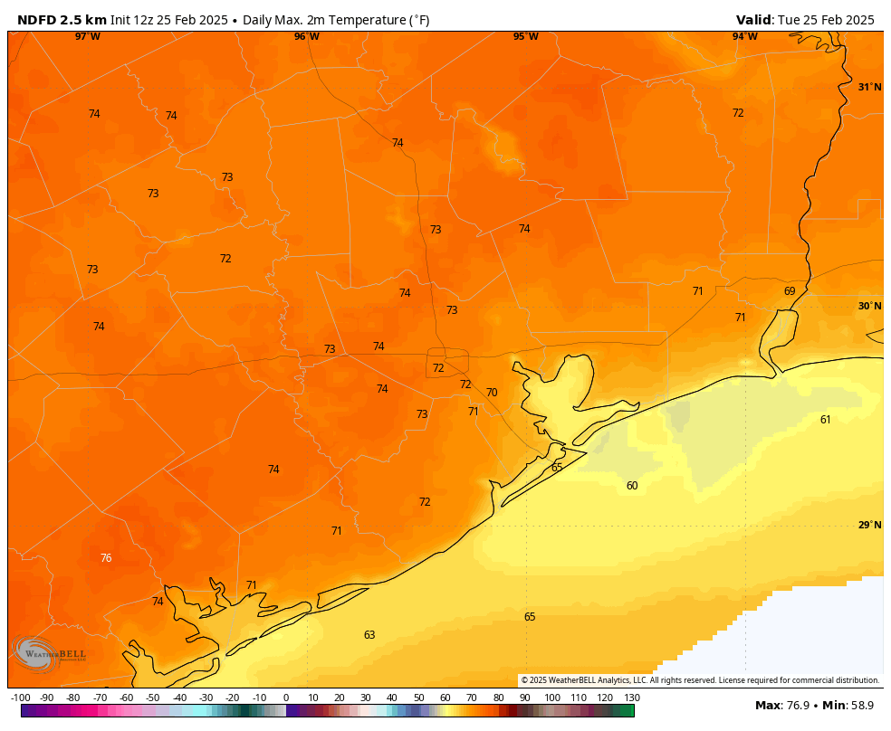
Tuesday
We are seeing widespread fog again this morning, and this pattern will repeat itself again on Wednesday morning, so be prepared. However as temperatures rise this morning, the fog will dissipate and we’ll be left with sunny, brilliant skies. High temperatures today will generally reach the lower 70s, with reasonably dry air. Winds will be light, from the southeast at 5 to 10 mph. It’s hard to beat this kind of weather, so if you can snatch a few moments outside this afternoon, you should. Lows tonight will drop into the low- to mid-50s, with fog developing again after midnight.
Wednesday
After the fog lifts on Wednesday we’ll see another mostly sunny day, with temperatures a bit warmer, in the upper 70s. Humidity will be a bit higher on Wednesday, but it won’t be unpleasant. Lows will be warmer, generally in the upper 50s. Fog development is likely again on Wednesday night before a cold front slides into the area on Thursday.
Thursday
The front’s arrival is likely to be a non-event aside from the development of some clouds on Thursday morning, possibly into the afternoon hours. While we cannot entirely exclude the possibility of a few light showers, I think the front’s arrival will be dry. Highs will be a bit cooler on Thursday, perhaps around 70 degrees. Lows on Friday night will likely fall to around 50 degrees in Houston, with cooler conditions for inland areas. With lower dewpoints, we should finally be rid of the fog for a bit.
Friday
We can expect another sunny, pleasant day with high temperatures in the vicinity of 70 degrees. Lows on Friday night will, again, fall to around 50 degrees, or a tick warmer.
Saturday
The first half of the weekend looks gorgeous. We can expect mostly sunny skies, and high temperatures generally in the low- to mid-70s. Some clouds will start to build during the afternoon and evening hours, and this will herald a slightly warmer night, in the mid- to upper-50s.
Sunday
This will likely be a partly to mostly cloudy day, with highs in the 70s. As the overall flow turns more southerly and the atmosphere more disturbed, we could see the possibility of a few light showers at some point on Sunday or Sunday night or Monday. But this is far from a slam dunk. Sunday night will be warmer, with lows possibly falling only to the lower 60s.
Next week
Our weather turns more humid on Monday and Tuesday, with high temperatures likely pushing up toward 80 degrees. Rain chances look to be modest, but non-zero. At some point, possibly on Wednesday, a front will push through to bring temperatures down. Even so, we are probably looking at nighttime lows around 50 degrees after the front, so it will likely be mildly chilly, rather than cold.

My 4 year old wants to know what causes fog….and I don’t know!
Fog is created when the air near the ground cools to its dew point. The ground radiates heat away from the ground faster than the air above. When the air just above the ground cools to its dew point, it saturates causing the that thick mist in the air we know as fog. It is basically clouds on the ground because they are both created the same way except clouds form thousands of feet above the ground due to rising warm moist air cooling and condensing.
Fog forms the best when skies are clear overnight and winds are calm. Clear skies radiate the heat away from the ground more efficiently, making the process for fog development more likely. Calm or slow winds help keep the fog suspended at the ground better.
The most common type of fog we get here in SE Texas is Sea Fog. This forms in a similar way. When winds return from the south after cold fronts, warmer more moist air from deep within the Gulf moves over the cooled waters close to shore. The cool air above the chilled water condenses into the tiny water droplets that make up fog. This phenomenon is something we see mostly during winter due to the colder waters near shore. We can get fog during the summer but not the dense widespread sea fog we experience during the late fall and winter because the ocean warmth is more uniform.
I meant to say that the clear sky radiates heat away from the ground faster than the air above
Thank you!
I still would not rule out a late spring frost. Sometimes the weather gets stuck in a persistent pattern. It’s been volatile and switching from warm to cold every few weeks or so. Probably connected to the ebbs and flows of the Madden Julian Oscillation. Considering our wild swings I would not rule out one more Spring fling towards colder than normal weather…
Historically speaking, that is a high possibility. Most years we see atleast one or more nights in the 30s in early or mid March. And we usually have a few nights in the 40s in April.
That would be nice. Meanwhile in the Eastern Pacific, it looks like La Niña is slowly fading away and warn neutral or maybe even weak El Niño may develop later in 25. Perhaps the Cane season might ease up a bit,Florida could use a break.
Cool cloudy days usually is in order during Niños. Hey that is a good 8 months away,
what happens in between,(summer) I don’t want to think about that. Maybe in May.
Nice & quiet ⚘
I already miss winter
Said no one ever
Thank you so much for what you do. It is greatly appreciated!
Wait, what? A week of mild temperatures without reaching the mid to upper 80s in between cold fronts. What has the world come to?