In brief: We are sharing this post from our companion site, The Eyewall, on the effects from Beryl across the state of Texas. If you’re looking for a TL;DR for Houston, it is this: Continue to monitor trends today and tomorrow. Make whatever preps you feel comfortable making or you feel are warranted. Current forecasts keep most meaningful impacts beyond localized flash flooding away from us.
Beryl’s future track
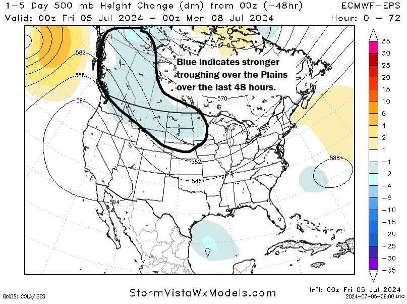
Beryl is going to be walking an absolute tightrope over the next 2 days. I say that for residents of Texas, because as Beryl turns, exactly where that turn occurs will have an outsized impact on who sees exactly what. For now, I think the key player is this trough over the Plains. Over the last 48 hours, models have tended to further strengthen the trough. That coupled with a slightly farther north track of Beryl has led to Beryl being able to “feel” the tug of this trough more, which is forcing Beryl to come a little more to the north when it gets into the western Gulf of Mexico.
So what exactly does this mean for Beryl’s forecast track? When you look at the 51 member European ensemble now, you can see that the majority of the members are turning Beryl northwest or even north northwest into Texas.
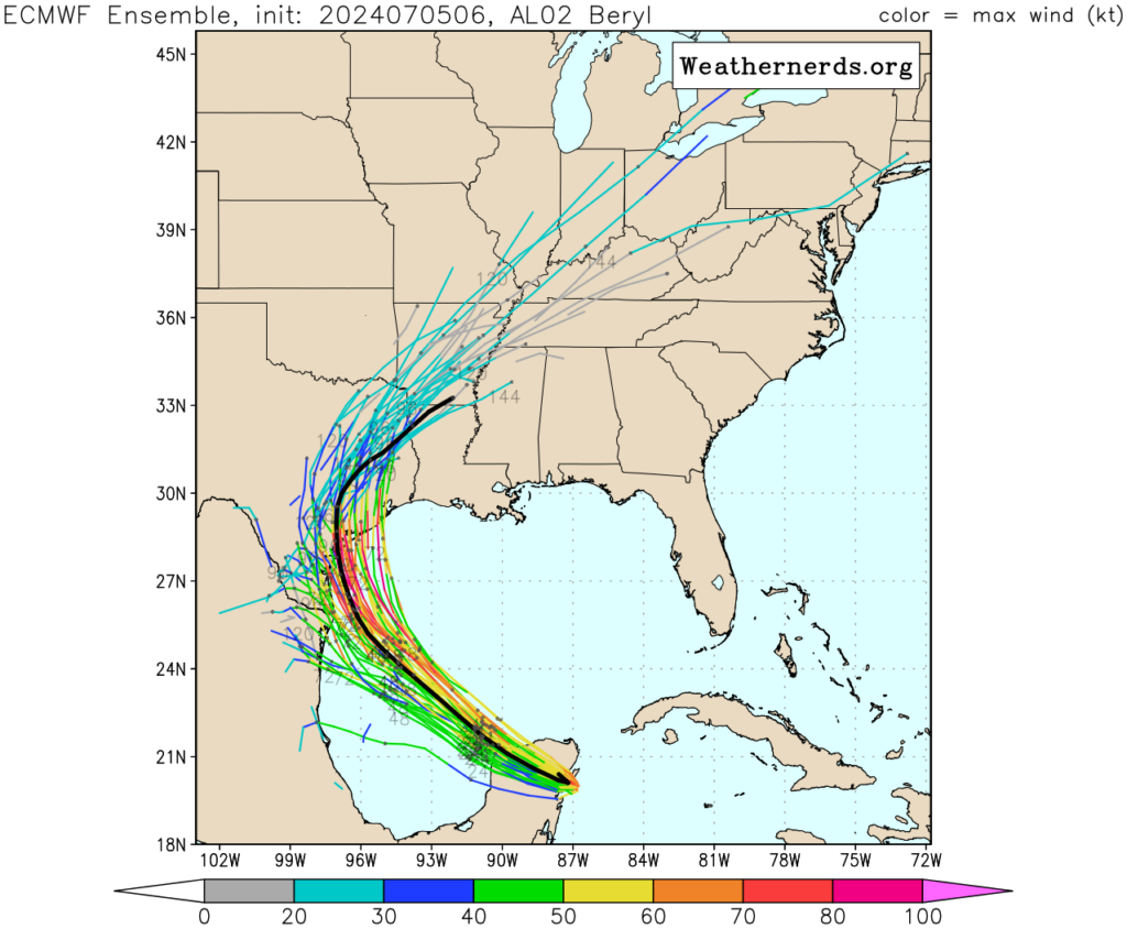
The problem is two-fold. First, where exactly does that turn to the north northwest occur? That will determine the landfall point on the Texas coast. Secondly, that landfall point will have tremendous impact on who sees what. A landfall in Matagorda Bay means the southwest suburbs of Houston could experience a full fledged tropical storm type outcome, whereas Corpus Christi would be pretty much fine. A landfall in Baffin Bay south of Corpus would likely deliver hurricane impacts to Corpus Christi and few impacts to Houston beyond thunderstorms and rain. Storms approaching at an angle, rather than more perpendicular to the coast provide a world of problems from communicating impacts. Literally a 15 mile change in the angle of approach can add or remove entire counties from certain expected impacts. My hope is that we’ll get some additional color on this by afternoon, and we will have another update this evening with the information.
How strong will Beryl get
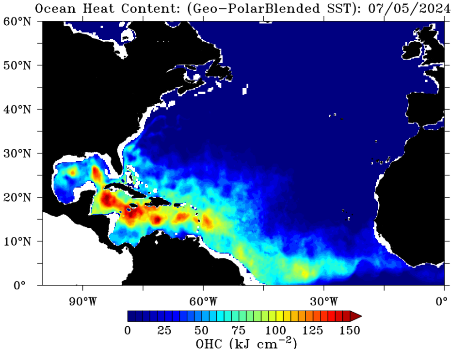
Beryl’s intensity will be contingent, somewhat, on what it looks like coming off the Yucatan. Assuming some organization still, as well as tropical storm status should allow it to begin to quickly re-intensify. The waters of the Gulf, or the oceanic heat content available to Beryl is not inconsequential, but it’s also not the Caribbean rocket fuel that it had on the other side of the Yucatan.
Still, this argues for steady intensification as Beryl comes toward the Gulf. Water temperatures immediately adjacent to the Texas coast are quite warm, so Beryl will not weaken on approach and should make landfall as a strengthening storm. Most modeling keeps Beryl as a tropical storm or a low-end hurricane as it comes ashore. The NHC forecast is slightly more aggressive than this, which is a stance I wholeheartedly agree with. I would plan for a borderline category 2 storm at landfall and hope for the best. The radius of hurricane force winds is currently only 30 miles out from the center, so Beryl is a relatively small storm. Do not focus on the intensity of Beryl other than if you live along the immediate coast, as this will likely deliver tropical storm wind impacts to most. However, widespread tropical storm winds and localized hurricane winds will still cause power outages and damage and should be respected.
In addition, while we don’t currently have a storm surge forecast, it is safe to assume that Beryl will deliver a surge and coastal flooding between Corpus Christi and Cameron Parish, LA. We will have more details on this to come, but expect something similar to Alberto’s impact last month, with pockets of worse conditions near and to the north of where the center comes ashore.
Beryl also a heavy rain and flooding concern
In addition to the hurricane impacts we normally see, Beryl will be a heavy rain producer for Texas. The current rainfall forecast is calling for locally 6 to 8 inches of rainfall, but I fully anticipate that this forecast will be upgraded some before all is said and done. Double digit rainfall totals are likely in a few spots with the most persistent rainfall and localized flash flooding is going to be a concern.
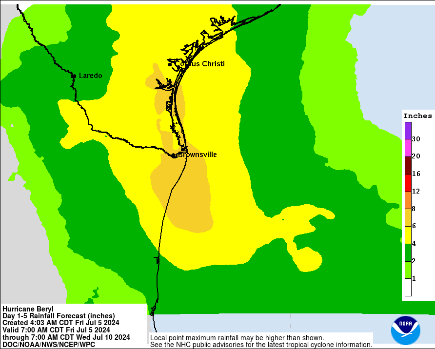
Beryl will not stall, so I want to make clear for folks in Texas that this is not a Harvey redux. However, Beryl will move slowly once ashore. Even relatively more progressive and faster models like the GFS dump up to 10 inches in spots. So the heavy rain concern is there. Expect more color on this later today as well.
The bottom line
For folks in the Rio Grande Valley: If you live in a flood prone area, keep an eye on the rainfall forecast for Beryl. Wind impacts will likely be confined to Brownsville and the coast.
For folks on the Lower and Middle Texas Coast and Coastal Bend region, including Corpus Christi: Prepare as if a hurricane is coming and make sure to follow local officials guidance in terms of evacuation if needed.
For folks in the Matagorda Bay area: Start making preparations in case the forecast shifts to the north and brings hurricane conditions closer to the area.
For folks in the Houston area: Continue to monitor trends today and tomorrow. Make whatever preps you feel comfortable making or you feel are warranted. Current forecasts keep most meaningful impacts beyond localized flash flooding away from us. Coastal residents prepare for at least minor to moderate tidal flooding.

See, once again y’all still can’t get your forecasts right.
Literally no one can right now! Your comment is ridiculous. Why are you even here? lol
Exactly. Several weather systems are in play here and we can’t control the weather just yet! Lol
Lol … They don’t have a crystal ball, sheesh. Forecasts are predictions; they don’t literally see the future. 🙄
Exactly. Take a breath and realize that SCW reads and interprets the models and tells us what the models are saying, except they put it into normal language without all the fancy scientific stuff so that avg people like myself can understand. Most of the time they dont share their personal opinion of what they think will happen, and I like that. If thats what you want, there are plenty of unqualified individuals playing meteorologist who would love to tell you what they think… just look at the comments.
Can you inform me who did get the forecast 100% correct? Because literally everyone from the Weather Channel, to Space City weather, to local news has had shifting forecast based on the trajectory updating over time…
Good grief! The National Hurricane Center has also adjusted their forecasts as well! What is wrong with you? Can you troll somewhere else?
This was meant for the naysayer who unfortunately decided to be the first to comment. I appreciate all of the SCW and Eyewall information!
you wanna forecast when your car is gonna break down and need to be looked at?
or you wanna forecast when there’s gonna be major accident on the road so you won’t be late for work?
you just can’t forecast these things 1-2 weeks in advance
What a horrible comment
I know central Texas is out of your neck of the woods, but we are desperate for rain out here. Is there any hope for areas west of Austin for some significant rainfall?
This is it… EVACUATE KATY NOW.
Would appreciate more information about Galveston Island.
I just went to the Ventusky weather website (discovered it yesterday).
.
I wasn’t sure which model it uses, but I discovered that in the Settings, you can change the model it uses.
And yes, the “default”(which is set as Automatic) is Global ICON.
.
In detail, it shows Beryl heading to Corpus, then on Sunday, it makes a turn to the north, then shifts to a north-north-east direction to Galveston / Houston.
You can go into Settings and instantly change which model it will use, either a Global model or Regional model.
.
I wonder why they default to Global ICON? Is it because this website is based in Europe?
Correction …. the default model in Automatic mode, after I input Magnolia TX, shows to be “ICON + HRRR”.
.
It predicts landfall around the Lake Jackson area on Mon at 4am.
I wonder if Ventusky was around when Harvey was … and what their prediction was (?)
Ventusky tryna to compete with Windy.com? lol
or could they be sister site?
Good information. Thanks for the update. Keep up the great work.
Thank you for your calm reports that stick with the science. Meteorological forecasting is notoriously complicated and changes based on the data. You’re doing a fabulous job, and your logical reporting allows me to reasonably make plans.
Yes, I totally agree. You guys are the best!
Agree 100%. Thanks, SCW!
I installed the jetpack app, but don’t understand it. It wants me to create a domain. Can you explain how it works in order to receive your tropical updates?
I found out the Cone shape is fixed, it doesn’t increase when models disagree a lot or when factors are complex. The shape is meant to be avg shape that is 67% certain for past 5 years of hurricanes. So even when forecasters are 99.99% sure Houston won’t get hit, if the track is hitting Corpus then the Cone will be drawn and will touch Houston even if track is 99.99 not gonna touch H Town. Wacky.
Galv Islander out here refreshing your site every other hour. Thank you SO much for your clear, honest and non-dramatic information. I get confused easily and get hyped even more easily so I appreciate your approach more than I can express. I trust your science and I trust your tone. THANK you.
The Hurricane Cone always is drawn same shape, wide. If you google and find the “spaghetti models” of 20 colored lines for Beryl, which tv channels like WESH in Orlando have, and MAKE SURE ITS RECENT MODEL with Hurricane now over Yucatan Peninsula, you will be reassured that ZERO of the 20 computer models are having Beryl hit Galveston. The 20 models they use vary, some assume a storm that changes direction easily, some assume a storm that curves a lot, and if none of the lines head for Galveston one can feel safe. The Cone is NOT the best tool to see when to worry. I am in Kemah on a boat, I am not worried. I will be very worried next month so save your energy for August!!!
The cone can go in any direction if you have a Sharpie. LOLOL
That makes sense. I appreciate that! And I’ll keep that in mind for the future. Plus it’s exactly what I want hear 🙂
Beryl’s historical path looks an awful lot like Harvey’s right into the Yucatan…
Agree with you @TM … path does look to mimic Harvey.
Sadly, we lost our Cypress home to Harvey, but we’re now on very high ground and further out, here in Magnolia 👍
Yep. Matagorda Bay looks to be where this thing wants to go- not far from Rockport. Harvey was slow moving, at least this has more speed, but I do worry about the speed once it turns north- hope it moves off quickly. Regardless, Houston area is going to get the dirty side of this.
The Hurricane Cone always is drawn same shape, wide. If you google and find the “spaghetti models” of 20 colored lines for Beryl, which tv channels like WESH in Orlando have, and MAKE SURE ITS RECENT MODEL with Hurricane now over Yucatan Peninsula, you will be reassured that ZERO of the 20 computer models are having Beryl near us. The Cone is misleading about how much to worry. DITCH THE CONE!!!??
Looks like the 12Z Euro model is now bringing a cat 3 into Matagorda Bay
Get ready for another shift in the models northeast. It looks like the remnants of the eye are going to exit the Yucatan north of the model guidance which means the cone of death will be shifting as well…
BUT ….. should Katy and Waller evacuate?
There were other websites/youtube channels suggesting this northward/eastward change in track days ago. Yall are late to the party.
Lately whenever SCW says not to worry – then, I know for sure I should worry.
Looks to me the storm is moving nearly due north to slightly northeast. Not blaming anyone in particular but what a blown forecast.