In brief: As a boundary pushes in from East Texas, the potential for storms is a little bit higher today than expected. However, while the line of storms currently on the radar is impressive, it’s not clear whether this system will hold together all the way into Houston.
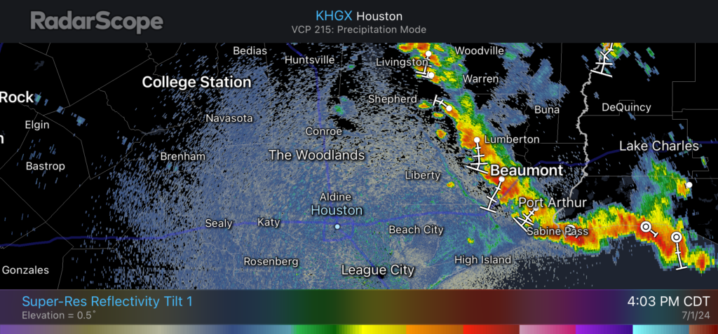
In this morning’s post I mentioned there was “a bit of intrigue” regarding storm chances on Monday afternoon as a boundary pressed into the area from the east. As of 4 pm CT this boundary is clearly visible on radar, having moved from Louisiana into East Texas, and now slowly creeping toward the Houston metro area.
Houston radar as of 4:03 pm CT Monday. (RadarScope)
To be frank, our high-resolution modeling guidance has completely missed the boat on this storm development today, and I don’t have a great answer as to what happens later this afternoon and evening. My best guess is that this boundary will continue to slide west, but as the storms approach and move into the Houston area they will weaken. But given the ample daytime heating over the next couple of hours, it is also possible the storms hold together and some sort of line pushes through between now and 9 pm CT.
With this post I simply wanted to call attention to the possibility that showers and thunderstorms may be a little bit more widespread this evening than previously expected. (We have no flooding concerns, regardless). Or, maybe the storms will fizzle out as they move into a slightly less favorable environment. In any case, expect the unexpected this evening.
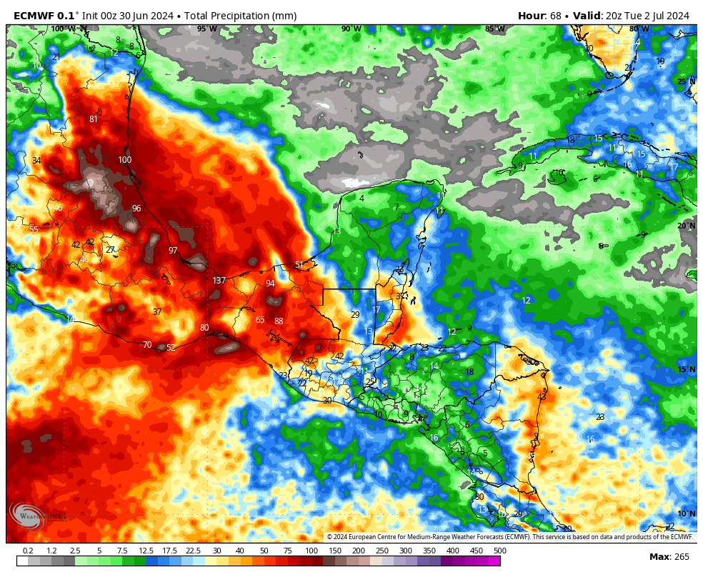
In brief: As July begins we take a look back at June’s rain and temperatures, and look ahead to a hot week to start the month. Rain chances will be on the low side this week, but some isolated showers and thunderstorms will nonetheless be possible. Hurricane Beryl should remain in the southern Gulf of Mexico this weekend, so it’s unlikely to affect our area.
A brief June review
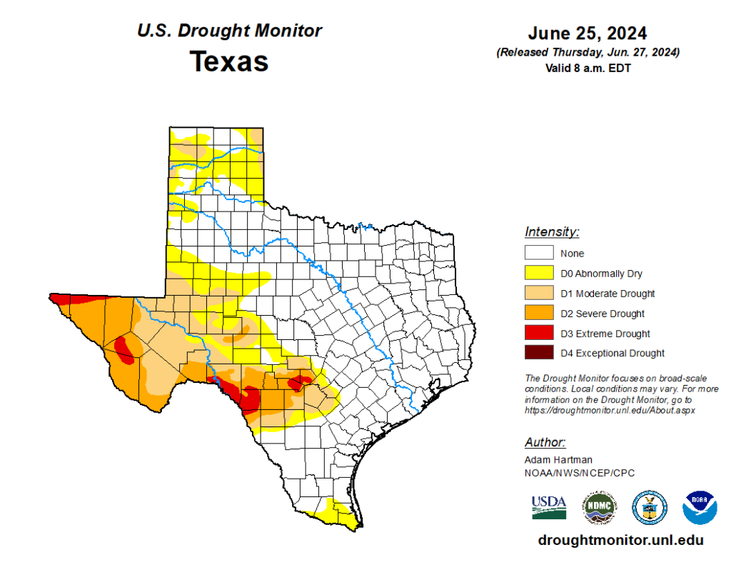
The month of June was wetter and warmer than normal. The city of Houston, officially, recorded 7.8 inches of rainfall, which is nearly 2 inches more than the average monthly rainfall for June. As a result of a wet spring, the entire eastern half of Texas, including all of the Houston metro area, is entirely out of drought conditions. It is a fine posture to be in headed into the hottest months of the year.
There is no drought in the eastern half of Texas. (US Drought Monitor)
In terms of temperature, the city of Houston recorded an average of 84.6 degrees, which is 1.6 degrees above the normal temperature recorded over the last three decades. The average high, of 93.1 degrees, was not far off normal. However, our nighttime temperature averaged 76.1 degrees, which is well above the normal June temperature of 73.7 degrees. This is consistent with a warmer Gulf of Mexico and the background pattern of climate change.
Monday
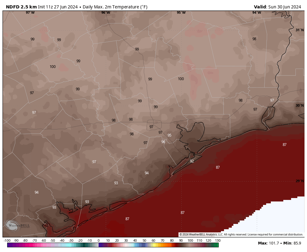
If you’ve been enjoying our hot and sunny weather, you’re in luck. This pattern should persist for much of this week. In truth, there’s not a whole lot to forecast when high pressure is more or less in control of our weather pattern. High temperatures today will reach the upper 90s, with plenty of sunshine and humidity. Winds will be light, generally from the south, at 5 mph or so.
There is a bit of intrigue when it comes to the possibility of some rain showers late this afternoon as a weak boundary pushes into the area. This may generate some isolated showers and thunderstorms across parts of Houston, perhaps near downtown. Overall rain chances today are probably on the order of 10 to 20 percent for most locations. Lows tonight will be warm, perhaps dropping only to about 80 degrees.
Most of this week should see high, but not extreme heat in Houston. (Weather Bell)
Tuesday
A day similar to Monday, with the possible exception of highs being a degree or two cooler. The setup for isolated showers is similar.
Wednesday, Thursday, and Friday
The overall pattern remains the same, although with high pressure slightly relinquishing its grip we could see highs only in the mid-90s rather than the upper-90s. Ongoing rain chances are similar in terms of the afternoons and early evenings possibly seeing a few isolated showers and thunderstorms. If you’re wondering about July Fourth fireworks, everything looks fine at this point.
Saturday and Sunday
At this point it appears that high pressure may back off still a bit further this weekend. If so, that may increase daily rain chances a bit, to perhaps 30 percent. It may also bring daytime highs down into the low- to mid-90s range, so more in line with temperatures more typical for early July. We’ll see.
Tropics
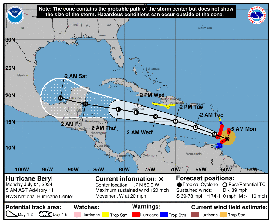
We’re continuing to closely watch the evolution of Hurricane Beryl, but at this time there are no indications that it will move into the central Gulf of Mexico and threaten the upper Texas coast. The most likely scenario at this time is, rather, that it tracks across the Yucatan Peninsula and into the Bay of Campeche. After that time the odds that it moves north toward Texas are increasingly low. So, for the greater Houston area, nothing much to worry about at this time.
Track forecast for Hurricane Beryl. (National Hurricane Center)
Also of note, Tropical Storm Chris formed last night in the Southern Gulf of Mexico, but it is already moving into Mexico near Tampico, and is not a concern for the United States. (Heavy rainfall, however, is likely in central Mexico). For full coverage of tropical activity, be sure and check out The Eyewall.
In brief: This tropical update has been cross-posted from our companion site The Eyewall. Although we do not yet have major concerns about direct impacts to Texas from Beryl, it is not out of the question that the storm could get into the Gulf of Mexico this coming weekend. Since we have been receiving a lot of questions about Beryl, here’s what we know right now.
Overview
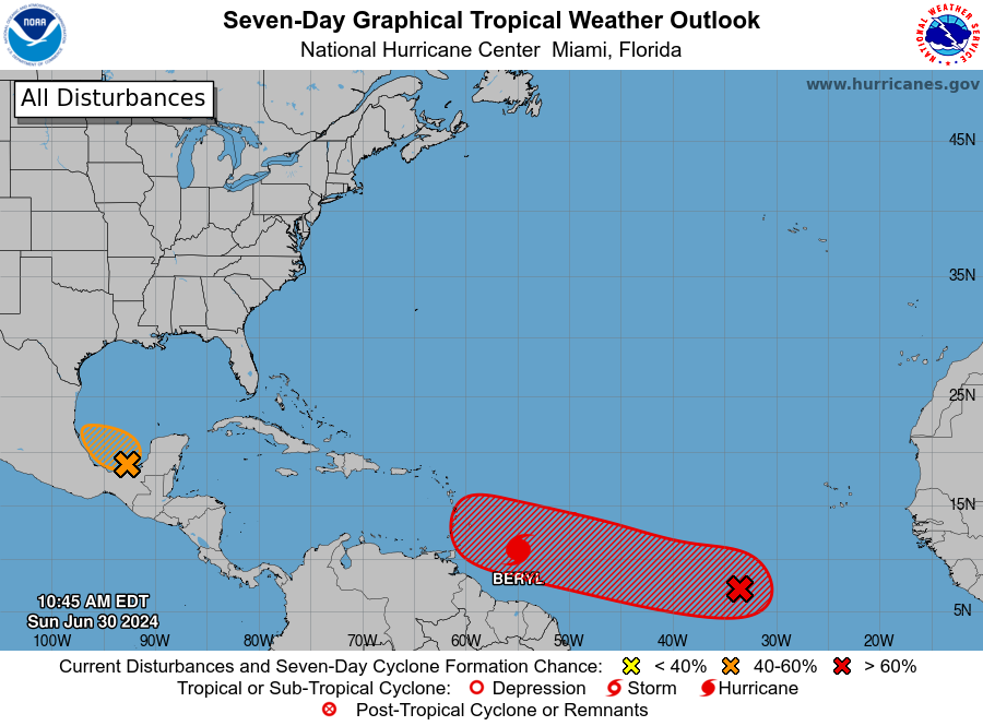
As of late morning on Sunday, the tropical Atlantic remains very active for the end of June. In addition to Beryl, there are a couple of systems the National Hurricane Center is monitoring for potential development. We’ll comment on those at the end of this post, but our primary focus today is the rapidly developing Beryl, which as of 10:35 am CT is a dangerous Category 4 hurricane.
The tropics are super busy for late June. (National Hurricane Center)
Hurricane Beryl this week
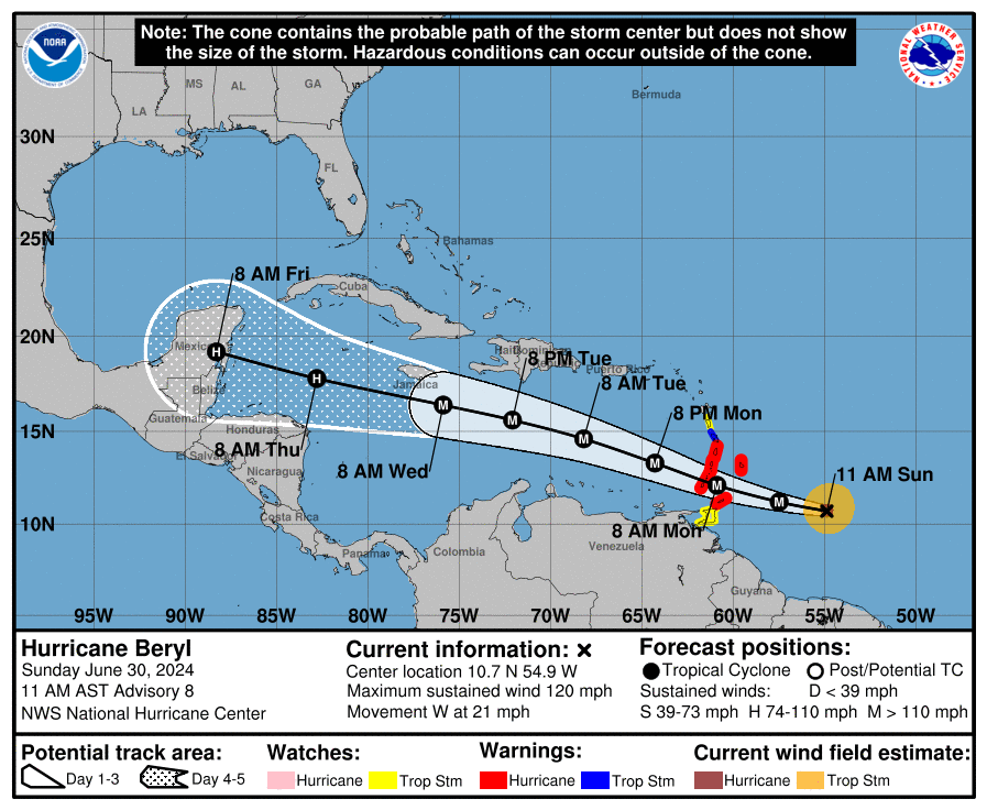
Thanks to warm seas, the system has intensified during the last 24 hours from a 50-mph tropical storm into a powerful 130-mph hurricane as it nears the Windward Islands. It should then cross these islands on Monday and move into the Caribbean Sea. The storm will likely remain sufficiently south of Puerto Rico and Hispaniola to preclude serious damage there, but it could threaten Jamaica on Wednesday and Central America and the Yucatan Peninsula toward the end of the week. After that? Movement into the Gulf of Mexico is possible, but after this point our confidence starts to decrease.
Confidence is high in Beryl’s track for the next few days. (National Hurricane Center)
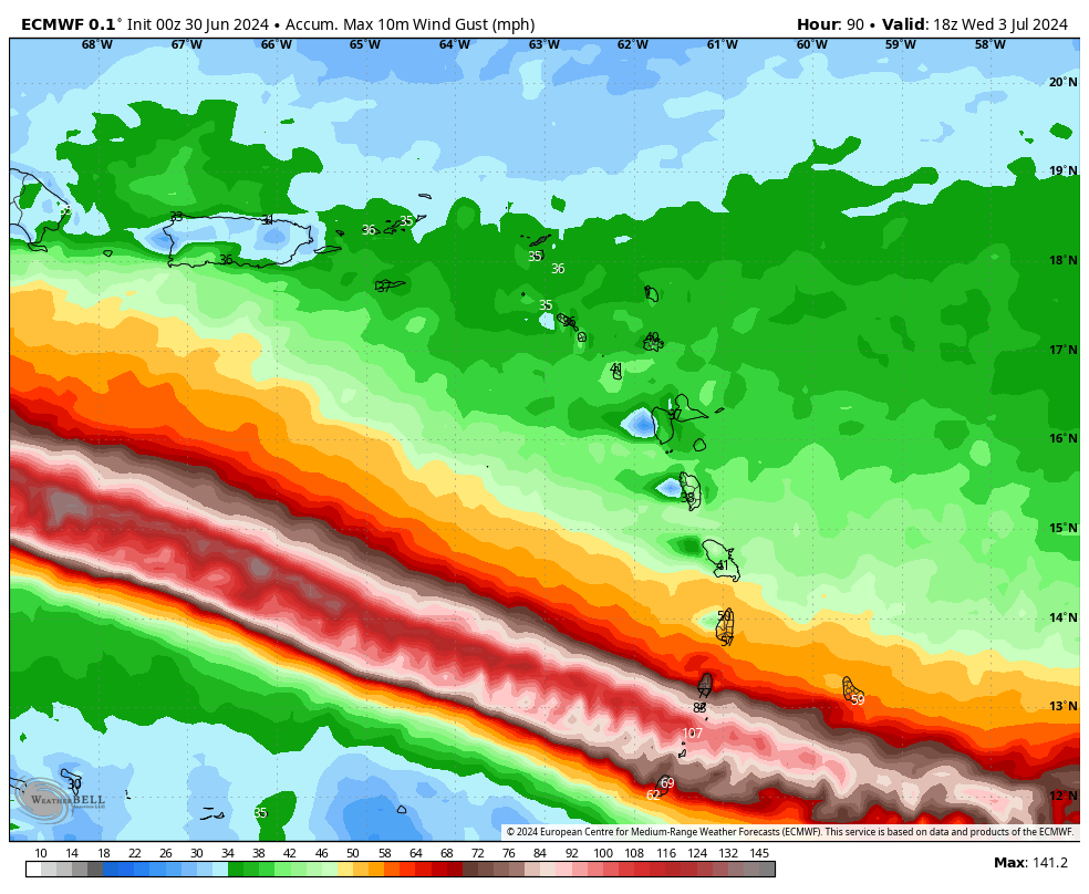
In terms of intensity, additional strengthening of Beryl is likely over the next 24 hours or so as Beryl traverses very warm seas and is encountering relatively little wind shear. The National Hurricane Center forecasts a peak strength of 140 mph sustained winds by Monday morning, when the storm passes near islands including Grenada, Barbados, St. Lucia, and Martinique. These locations should prepare for the most intense wind and surge impacts beginning after midnight tonight, and lasting through at least Monday morning. Localized rain totals of 6 to 12 inches are possible. This is a very serious situation, and residents should prepare accordingly.
European model forecast for maximum wind gusts due to Beryl through Wednesday morning. (Weather Bell)
As it moves into the Caribbean Sea on Monday and Tuesday, Beryl should encounter moderately stronger wind shear, and this probably will cause some weakening. But the jury is very much out on how much weakening will occur before Beryl approaches Jamaica on Wednesday. The National Hurricane Center forecasts the system having sustained winds of 120 mph at that time, but this is just a reasonable guess. By Thursday night or Friday, as the center approaches Belize and the Yucatan Peninsula of Mexico, it’s likely that Beryl will weaken a little bit further. It will still likely bring hurricane-force winds to these locations sometime between late Thursday night and Friday night, in addition to heavy rainfall.
Hurricane Beryl this weekend
Our certainty about Beryl’s track begins to fade by the weekend. From now through Friday, a fairly strong high pressure system should continue to push the storm westward. Over the weekend and into early next week, it is possible this ridge continues to steer Beryl westward into the Bay of Campeche. (It is not clear how much interaction with the Yucatan would disrupt Beryl’s circulation, but some weakening is virtually certain). In this scenario, Beryl is likely to move across the southern Gulf of Mexico and plow into the east coast of the Mexican mainland, similar to Tropical Storm Alberto about 10 days ago.
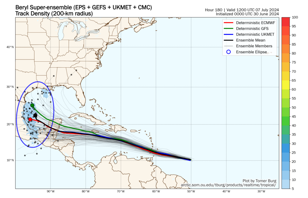
Super-ensemble forecast for Hurricane Beryl. (Tomer Burg)
However, there is also the possibility that this ridge weakens, somewhat. At this point, this remains a lesser likelihood when we look at the global models. Still, there is a non-zero chance that Beryl turns northwestward after encountering the Yucatan Peninsula. In such a scenario a tropical system—be it a tropical storm or hurricane—could come to the Texas or even Louisiana coast late next weekend. I understand that everyone would like to have absolute answers about whether this will happen, but we just don’t have that kind of certainty right now.
Bottom line: Direct Texas impacts are within the realm of probability from Beryl, but the odds remain fairly low. We can see this distribution of possibilities when we look at the “super ensemble” track of forecasts for Beryl, which favors the ridge holding strong. We should know more about this part of Beryl’s forecast by Monday or Tuesday, and of course we’ll remain on top of that.
Invest 94L
There is still a short window for this tropical disturbance over the southern Gulf of Mexico to develop on Sunday before it likely moves inland into Mexico on Monday. The primary threat from Invest 94L is heavy rains in southern Mexico and Central America, which saw similar impacts from Alberto just 10 days ago. Regardless of whether this system develops further or not, the effects will be the same. There will be no impacts for Texas.
European model forecast for accumulated precipitation from Invest 94L through Tuesday morning. (Weather Bell)
Invest 96L
The third area of tropical interest is trailing Hurricane Beryl by a few days as it traverses the open Atlantic Ocean. The National Hurricane Center gives this system a 70 percent chance of becoming a tropical depression or storm during the next week, and at this point it seems likely to impact the Windwards Islands in a similar location. This could happen as soon as Wednesday, and could deliver an awful second whammy.
However, I have some questions about how much Beryl will perturb the ocean and atmosphere, and this could help to mitigate the strengthening of this tropical disturbance as it nears the Caribbean Sea in a couple of days. We will be keeping a close eye on the system, in any case.
In brief: We’ll have a couple of more afternoons where some scattered showers will be likely, bringing a bit of welcome rain and briefly cooler temperatures. By this weekend we’ll be pushing the upper 90s, with the chance of hitting 100 degrees for the first time this year in Houston. Also, skies will be hazy due to Saharan dust.
Thursday
Today will have a similar setup to Wednesday, when we saw the development of some scattered thunderstorms across central and some southern parts of the region (mostly) during the afternoon hours. Again we’ll be on the periphery of high pressure, allowing for the seabreeze and daytime heating to do some work.
Rain chances this afternoon are probably about 30 percent, and some areas could see as much as half an inch of rain beneath stronger thunderstorms. Highs will depend on the extent of showers in your locality, but I still expect much of the region to get up into the mid-90s. Winds will be very light, from the southeast at maybe 5 mph. Lows tonight will only drop to about 80 degrees.
Friday
A similar day to Thursday, although perhaps with slightly less rain coverage. Highs again will push into the mid-90s for the most part, with light southerly winds.
Could we see some 100s in the Houston area by Sunday? Yes. (Weather Bell)
Saturday and Sunday
The weekend looks very warm as high pressure becomes a little bit more dominant. Rain chances will go down, close to zero percent on Saturday, and maybe 20 percent or so on Sunday. Daytime highs on Saturday will be in the mid- to upper-90s, and then on Sunday some locations could reach 100 degrees for the first time this year. Please take heat precautions if you’re going to be outside during the middle of the day this weekend.
In addition, we’ll see the influx of Saharan dust, which will produce hazy conditions over the Houston region this weekend. For most people this won’t have significant effects, but it could make sunsets more brilliant.
Next week
Monday will be very hot, bringing the region another chance to hit 100 degrees. There also will be a limited chance of rain showers, perhaps 20 percent. Most of next week should be similar, although slightly cooler. Expect highs in the mid- to upper-90s for the most part, with isolated to scattered showers during the afternoon hours along the seabreeze.
Here come the Atlantic tropics. (National Hurricane Center)
Atlantic tropics
After a (very) brief lull following Tropical Storm Alberto, the Atlantic tropics are starting to come to life. The deep Atlantic seems to be heating up earlier than normal, likely due to the excessively warm temperatures in the main development region of the ocean. We’re starting to see a more active African “wave train,” which is the source of the majority of hurricanes during the Atlantic season. Typically this does not get going for at least another month, but here we are.
There are a couple of active systems, but the one to watch is the trailing disturbance, shown in red on the map above, known as “Invest 95L.” (Invest simply stands for “area of investigation”). We’ll be providing deeper coverage of this system on The Eyewall, but what I would say right now is that there’s a low-end chance this disturbance eventually reaches the Gulf of Mexico in about 10 days time. Really, it’s not something I’d be too concerned about. But we’re keeping an eye on it, just in case.