In brief: It will be warm in Houston this week until it’s not. An Arctic front will arrive on Friday night and drive temperatures down to their coldest level of the season. We are tracking the dual threats of a hard freeze this weekend as well as the potential for freezing rain and icy roads. Buckle up y’all, because it is winter storm season!
Winter storm potential
The state of Texas faces the potential for a significant winter storm this week beginning Friday evening, and lasting into much of the weekend. This will be driven by an Arctic front surging into the southern United States, bringing the coldest air of the season down into Texas. This front will also bring a decent shot of lingering precipitation, and for the northern half of Texas this will mean a mix of snow, freezing rain, and sleet. Expect significant mobility issues in the metro areas of Dallas-Fort Worth and Austin, and possibly San Antonio.
As for Houston, the outlook is less certain. We are going to get very cold air, and almost certainly a freeze by Saturday evening. But it is not clear whether the freezing temperatures will arrive before the showers end. I think it is highly likely that areas along and north of Highway 105 (which runs from Navasota to Conroe to Cleveland) will see freezing rain on Saturday or Saturday night. But while there is clearly the potential for freezing rain further south, in the Houston metro area, we cannot yet say so for sure.
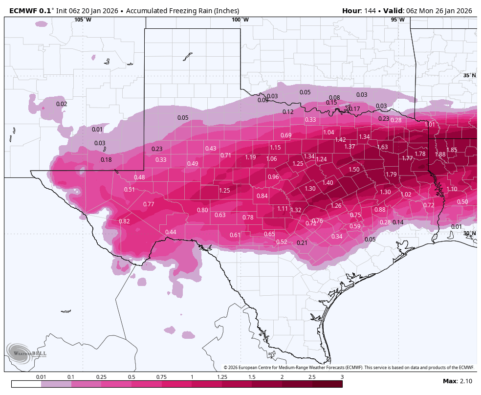
What we can tell you with confidence this morning is that travel north and west of Houston, beginning Friday evening, will start to become hazardous. There is the potential for icy roads in Houston itself on Saturday, Saturday night, and Sunday. You also should begin to take precautions for a possible hard freeze, in which temperatures fall below 25 degrees. This is not a certainty, but it is a possibility for all but coastal areas.
Tuesday
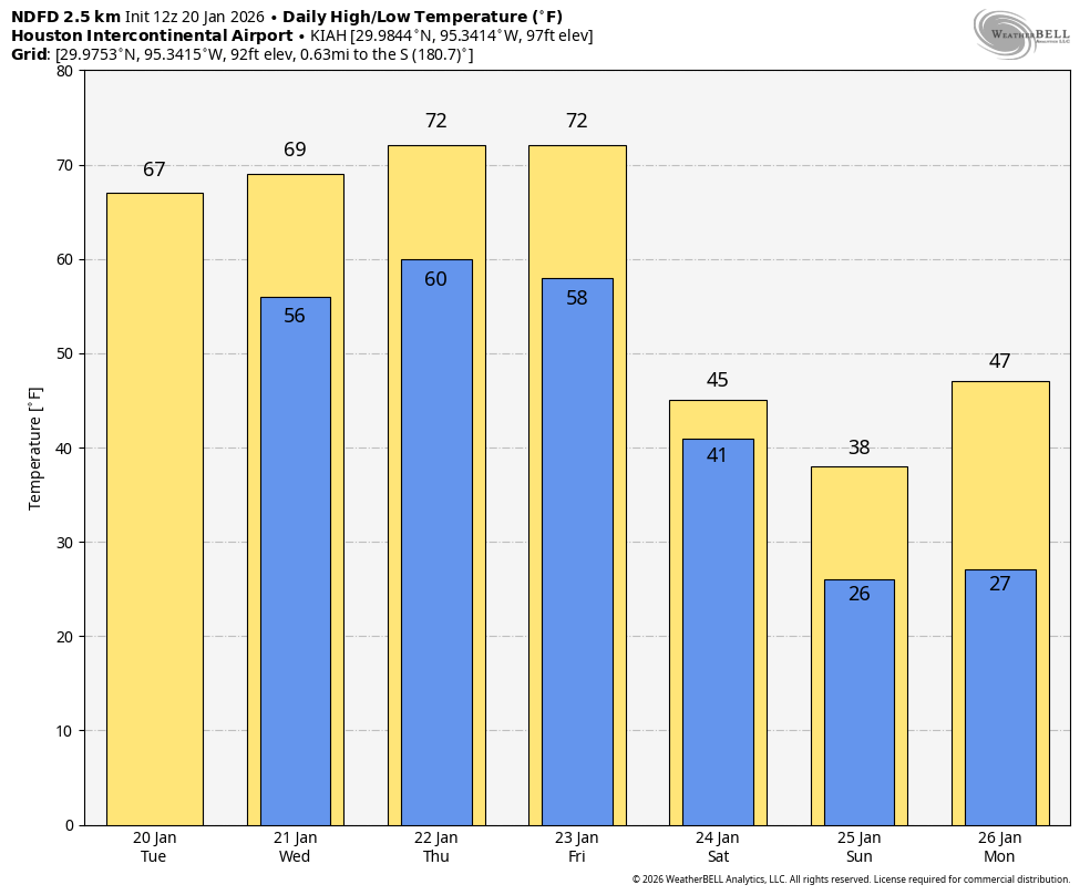
If you prefer partly sunny skies and mild temperatures, then today is the day for you. There will be a brief window this afternoon when I think we’ll see a decent amount of sunshine, with temperatures rising into the mid- to upper 60s. Winds will be light, from the east. Lows tonight will be warmer than we’ve been experiencing, in the upper 50s.
Wednesday
A weak front will sag into the area on Wednesday and die, and this will bring us mostly cloudy skies and a healthy chance of widespread, light rain. I don’t expect serious accumulations, but many areas will likely pick up a few tenths of an inch of precipitation. Temperatures, otherwise, will be about 70 degrees with modestly humid air. Lows on Wednesday night will only drop to about 60 degrees. As a result some fog will be possible early Thursday.
Thursday
This will be another mild day, with highs around 70 degrees, or perhaps a bit warmer, with mostly cloudy skies. There will be a slight chance of showers. Expect another warm night, with lows only in the range of 60 degrees.
Friday
This will be our third cloudy, warm-ish day in a row, with highs likely in the low 70s. But by Friday evening the Arctic front will be dropping our way. This should support the development of some rain showers during the afternoon and overnight period. Lows on Friday night will drop into the 40s.
Saturday
This will be a cold and gray day, with a healthy chance of rainfall. Depending on how cold it is at various locations, but especially north of Interstate 10, we may start to see some freezing precipitation. I think for areas in Montgomery County and points north, air temperatures may reach freezing early on Saturday, so that’s why we have concerns about freezing rain. A more widespread freeze is likely in Houston and surrounding suburbs by Saturday afternoon or evening, and if the roads are wet they would freeze. Additionally, some light precipitation remains possible on Saturday night, and this would likely take the form of freezing rain.
The bottom line is that there is the potential for slick streets north of Houston on Friday night, and in the city itself beginning Saturday afternoon or evening. We will be watching this closely, of course, as the difference between rain and freezing rain is but a degree or two. Lows on Saturday night will probably drop into the mid- to upper-20s in Houston on Saturday night, but there remains a large dollop of uncertainty there.
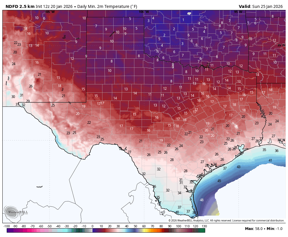
Sunday
I think this will be partly sunny day, so I’m hopeful that air temperatures will climb above freezing area-wide by around noon, but I’m not confident this will be the case. It will be a cold day regardless, with highs likely in the 30s. Again we are going to have to monitor the potential for icy streets depending on how much moisture is left on roads, and whether there’s any additional light precipitation on Sunday (maybe a 10 or 20 percent chance). Lows on Sunday night will probably be similar to Saturday night, dropping into the 20s. But will it be low- mid- or upper-20s for Houston? Probably closer to the latter, but I’m not confident yet.
Monday
Temperatures should rebound a little bit by Monday, with mostly sunny skies, and reaching perhaps 40 degrees. This should end the threat of icy roads, but we cannot rule out impacts on Monday morning. Stay tuned.
Next week
There’s still some division among the various models, but most likely we will see a stretch of sunnier weather, with highs in the 40s and 50s, and lows at or above freezing. We’ll see.