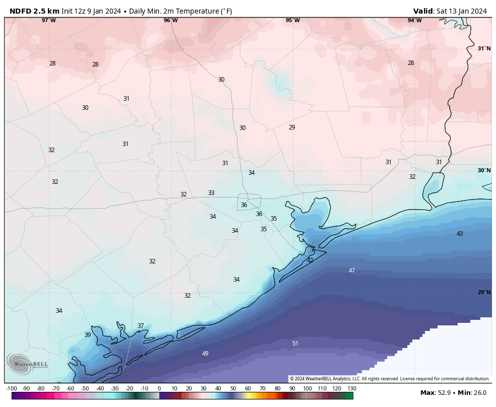
Good morning. There are some changes in the forecast for our upcoming cold spell, which looks to arrive earlier than anticipated. There is also a slight chance of some wintry precipitation on Sunday night into Monday morning, but the overall odds remain against this for now. The key point is this: There remains a lot of uncertainty about the details of this Arctic outbreak, but they should come into better focus over the next 24 to 36 hours. So please be patient. Matt and I will be here all along the way to tell you what we know, and what we don’t. For now, any preparations you make for the cold should be completed by the end of Saturday.
Thursday
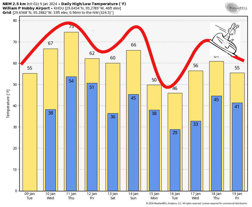
As expected there is fog, some of it dense, across much of the metro region this morning. As it clears we’ll see partly sunny skies and warm temperatures today, with highs pushing into the mid-70s. Southerly winds, gusting at times to 20 or even 25 mph, will be possible. Conditions change tonight as a fast-moving front drops through the area. Expect it to arrive near Katy and The Woodlands a couple of hours after midnight, push into Houston during the wee hours, and move offshore before sunrise. A broken line of showers, and possibly a few thunderstorms, may accompany the front. Overall rain chances are fairly low, however, as I expect a capping inversion to hold sway.

Friday
This will be a cold, blustery day. Skies will be sunny, but winds will be strong out of the north, gusting to 35 mph or so at times. If you’re like me and just finished picking up limbs from winds earlier this week, prepare for round two. Highs will reach the upper 50s, but may stop there. Winds will drop off pretty significantly during the afternoon and evening hours, and this will allow for ideal cooling conditions overnight. I expect lows in most of the Houston metro areas to remain above freezing, but a light freeze is possible for inland areas.
Saturday
After the cold start this will be the last warm-ish day before the Arctic front arrives. We’re looking at partly sunny skies, with high temperatures in the low 60s. Winds will be light. Lows on Saturday night will drop into the low- to mid-40s.
Sunday
Alright, here’s where the uncertainty kicks in. We’re just coming into range of some of the higher-resolution models, which tend to do a better job handling the timing of colder air masses like this. As we see additional model runs today, we should continue to get a better focus on the timing of the front. So I want you to understand that my confidence is low here, and we’re going to need to write the forecast in pencil for a little while.
With that said, the high resolution modeling is indicating that the front could reach Houston by around sunrise on Sunday. Yes, you read that right. If this is the case, temperatures on Sunday morning could be in the 30s for Houston marathon, with northerly winds. (I don’t expect precipitation at this time). This obviously is a significant change from previous forecasts, and something we’ll need to fine-tune. Again, it depends on the timing of the front.
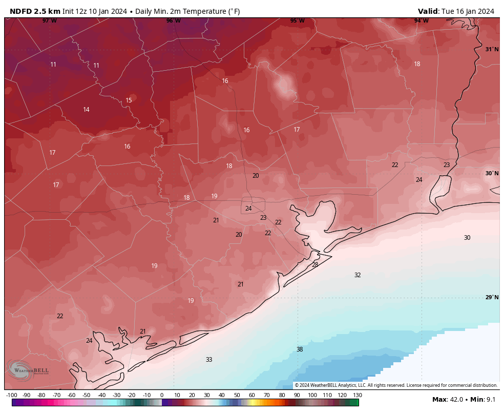
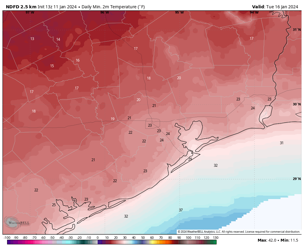
A widespread freeze looks likely for Sunday night, with areas inland of Interstate 10 possibly seeing lows in the mid-20s.
As to the question of freezing precipitation, there are hints of it in the models but nothing concrete. We really need to see more data from the high-resolution outputs before I have any confidence. For now I’d rate the chance of seeing any wintry precipitation, either in the form of sleet or freezing rain, at about 25 percent. I still don’t think it will be significant issue for roadways, but obviously it’s something we’re going to be watching closely.
Monday
This will be a cold day, with highs likely in the mid-30s for most of the metro area. As part of this Arctic front, lows will bottom out on Monday and Tuesday nights. Again, with these temperatures, there is some considerable uncertainty. For areas south of Interstate 10 we are probably looking at lows in the low to mid-20s, whereas areas further inland will be upper teens to low 20s. We will see.
We’ll have another update this afternoon to see where we are with the frontal timing, and lows early next week.