In brief: In today’s post we discuss the ongoing forecast with a winter storm that is due to arrive in Houston about 36 hours from now. With this update we list some things we know, and some we don’t about the forthcoming freeze.
Overview
Good afternoon. We are about a day and a half from freezing temperatures descending into the Houston metro area. Not much has changed with our overall forecast. Area roadways should be fine through Saturday evening, but by early Sunday we have questions and concerns. At this point I’m a little more bullish on ice in the Houston metro area, so I am leaning a little more toward a disruptive event on Sunday and possibly Monday morning, especially for locations north of Interstate 10. But it is far from a done deal.
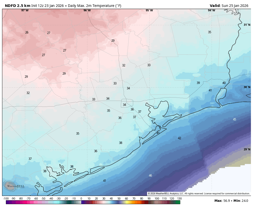
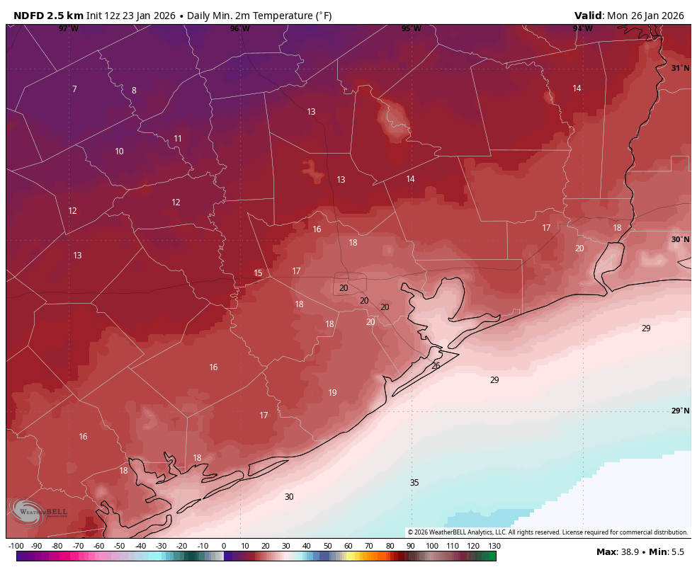
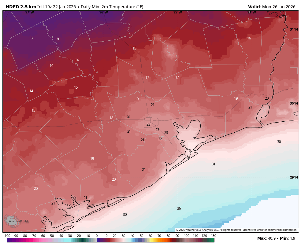
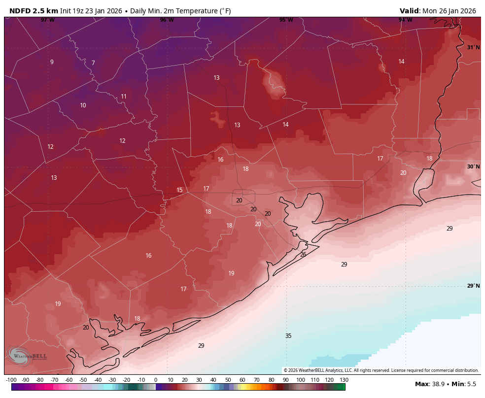
We also still have questions about how cold temperatures will get on Monday and Tuesday mornings. I would ballpark lows at about 20 degrees in urban Houston (a little cooler for inland sites such as Katy, Tomball, The Woodlands, and Kingwood) and a little warmer for locations closer to the coast, such as League City. But there is the possibility those temperatures are too low. Anyway, on to what we know, and what we don’t.
We know: If you need to make a closure decision now, err on the side of caution
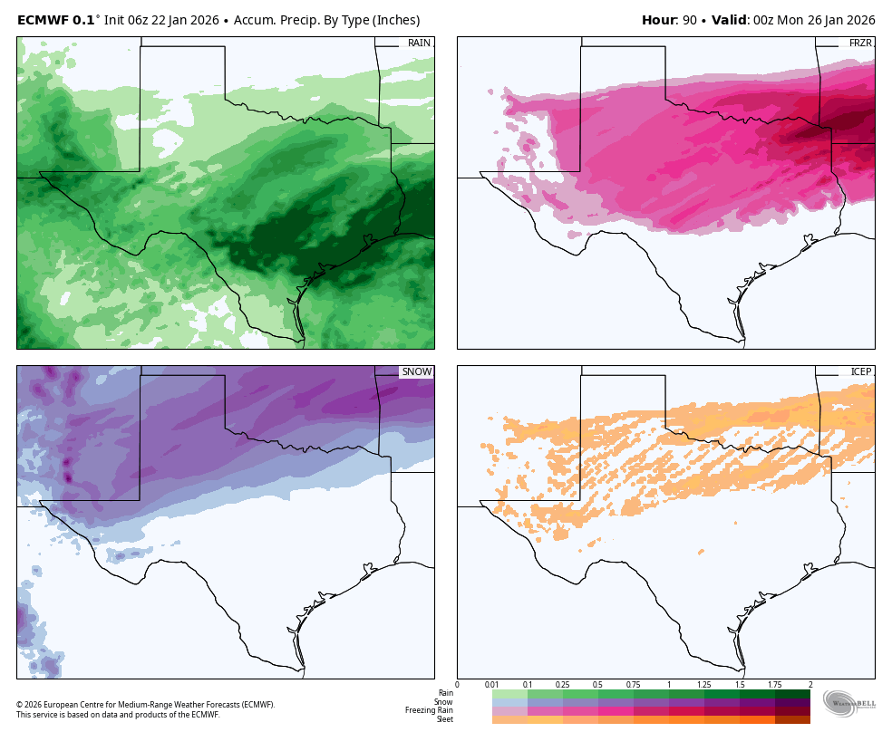
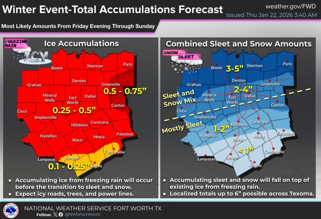
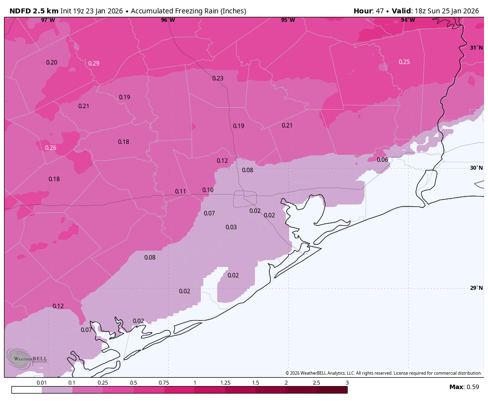
I’m still not sure what Houston’s roads will look like on Sunday morning, later in the day, and on Monday morning. Following precipitation on Sunday morning, which could fall as freezing rain or cold rain, we could be anywhere from “bone dry” to “icy bridges and overpasses” to “widespread ice” by Sunday afternoon. I know this is a huge cop-out, but it’s the truth due to uncertainty about air temperatures on Sunday. Anyway, we’ve already seen decisions by the Houston Independent School District and a handful of other districts to close on Monday. This is understandable, given the uncertainty. If you can’t wait to make a closure decision, that’s prudent. If you can wait, there’s still a chance things will be mostly fine on roads.
We don’t know: What will happen with electricity?
There are two issues with getting electricity into your home. The first of these is generation. This was the killer during the February 2021 winter storm, when large chunks of the Texas power grid were taken offline due to plants shutting down. If you’re like me, you’ve been periodically checking the “supply and demand” projection from ERCOT. Everything looks more of less fine, but there does appear to be a potential supply crunch on Monday morning, around sunrise, when temperatures are at their coldest.
The other issue is distribution, with the main concern in ice accumulating on tree limbs and power lines, causing them to snap. CenterPoint Energy, which is responsible for distribution in the greater Houston area, says they are making all necessary preparations. The bottom line is that I don’t expect to see the extreme and disastrous power losses experienced during the winter storm of 2021. But that’s not to say there won’t be some disruptions in service.
We know: People are panic shopping
I’ve heard from people, and can see from social media, that y’all are raiding grocery stores for all manner of supplies. (Pro tip: Kroger appears to be less crowded than HEB). But you don’t need to stock up forever, friends. Regardless of what happens, roads will very likely be passable on Monday afternoon, and at the very worst Tuesday when we’re back up into the 40s.
We don’t know: How low will temperatures go?
Forecasting low temperatures is difficult during winter events like this. One factor is ice. If there is a lot of it covering areas north of Houston, and within the city itself, than northerly winds moving over this ice will cool down more efficiently. This will lead to colder temperatures (possibly teens) in and around Houston. However it is also plausible that much of the city only drops to about 25 degrees. Our best advice is to prepare for the colder temperatures, and hope for “warmer” conditions.
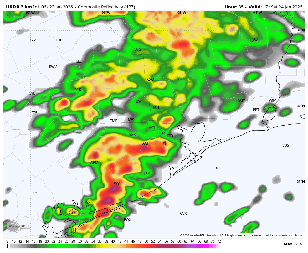
We know: Thunderstorms are possible on Saturday
A decent line of thunderstorms will pass through Houston on Saturday morning, likely during the mid-morning hours. Thunderstorms will be more likely along and south of Interstate 10 and closer to the coast. These could drop 1 to 2 inches of rain pretty quickly, so keep that in mind as part of your winterization preparations. After these storms pass I expect a lull in rain (for the most part) as temperatures drop into the 40s on Saturday afternoon. A second round of showers will likely spin up early on Sunday and persist into the mid-morning hours.
We don’t know: How airports will be affected
I know, you have flight questions. I wish we had answers. Flying on Saturday should not be problematic, but it’s difficult to say the same about Sunday and possibly Monday morning. Of note, many airlines have issued waivers for change fees for today through Monday.
We know: Space City Weather does not use made up storm names
The Weather Channel, as it has done for more than a decade, has named the impending winter storm “Fern.” These names are not official, and there is no significant evidence they do anything to enhance safety. Also, “Fern” is a pretty dumb name for a storm. So we won’t be using it (just like we have never used “Uri” for the 2021 deep freeze).
Our next update will be posted by 7 am CT on Saturday. I will also be doing an additional Q&A at 11 am tomorrow on our Facebook page. Thanks for your patience as we work through a difficult forecast here.