In brief: The Houston Marathon starts in less than 18 hours, and I wanted to provide a final forecast update with a few tweaks as you prepare for the race on Sunday morning.
Good afternoon! I hope all my fellow runners are practicing proper carbo loading exercises today in preparation for the marathon on Sunday. I just wanted to call attention to a few tweaks in the forecast for tomorrow morning.
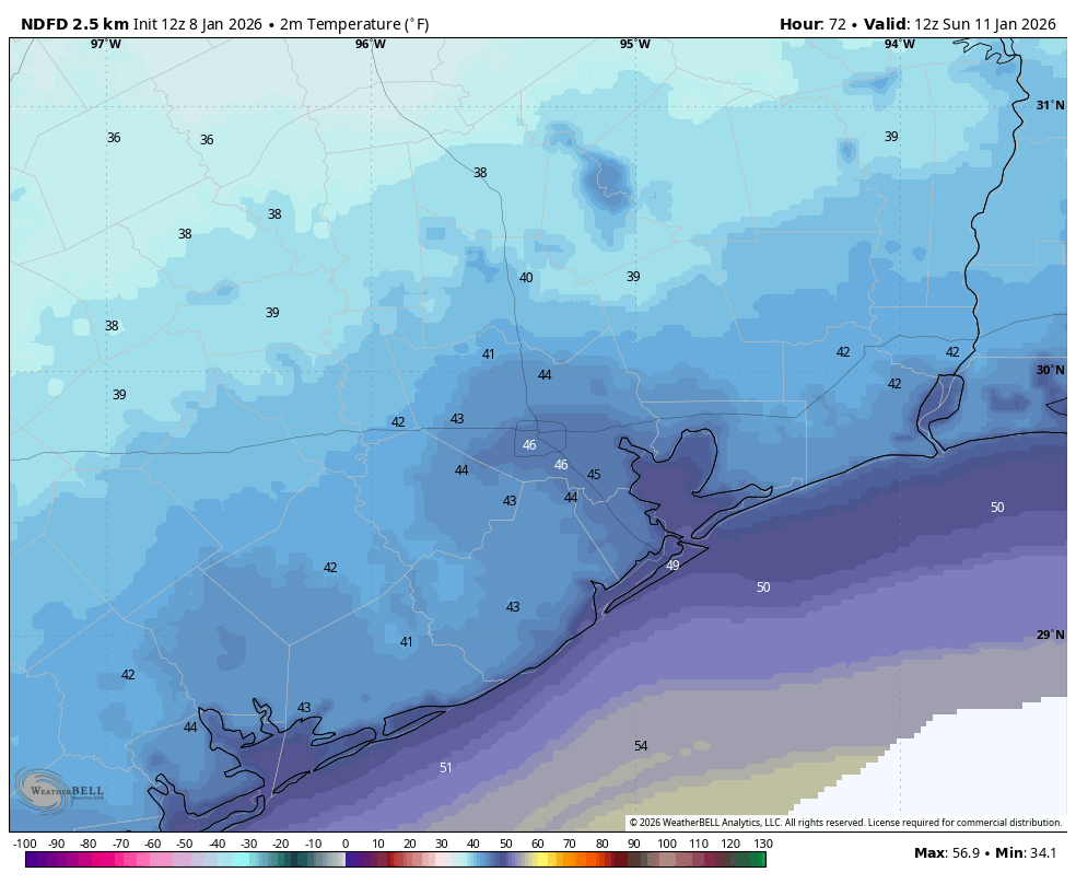
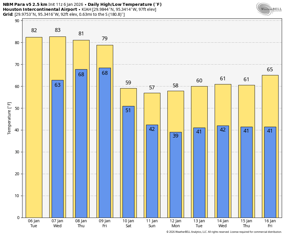
Temperatures: Some of our highest resolution models are trending a little lower in terms of temperatures at sunrise on Sunday. At this time I would therefore predict temperatures at 7 am are closer to 40 degrees than 45, and they will likely remain in the 40s until around 10:30 or 11 am. So you can count on fairly cold conditions throughout the race.
This is probably a realistic guess at the lowest possible temperatures on Sunday morning. I expect we’ll be a tad warmer than this, but wanted you to be be prepared. (Weather Bell)
Winds: I’m sure more than a few of you stepped outside into the blustery conditions today and wondered whether these winds are going to persist into Sunday morning. We can confidently say no, they will not. As we’ve been predicting for several days, winds will be elevated in the aftermath of the frontal passage, but gradually settle down. Wind gusts of up to 20 mph will be possible until around midnight tonight, but then should die down. During the race on Sunday morning I expect very light winds at the start while we’re waiting in the corrals. By mid-morning (you know, probably right about the time you hit mile marker 14 and head north on Post Oak) they may pick up to about 10 mph, with some slightly higher gusts from the north. Still, they’ll be nothing like last year.
Skies: I think they’re going to be mixed. I don’t have great confidence in the cloud cover forecast. My sense is that we’ll start out mostly cloudy early in the morning, with gradual clearing throughout the race. But honestly, I’m not sure.
Precipitation: None, unless we’re counting perspiration. In that case, plenty. Good luck, everyone!
In brief: Today’s post discusses the possibility of thunderstorms with a front on Friday night, folllowed by a cooldown that will stick around for awhile. Winter, it seems, really might be here. Also, start line conditions for the Houston Marathon are the best I can recall.
Storms possible Friday night?
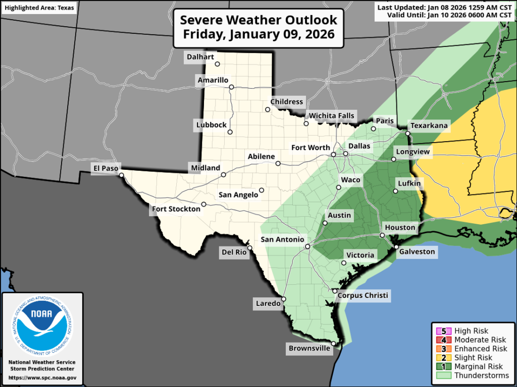
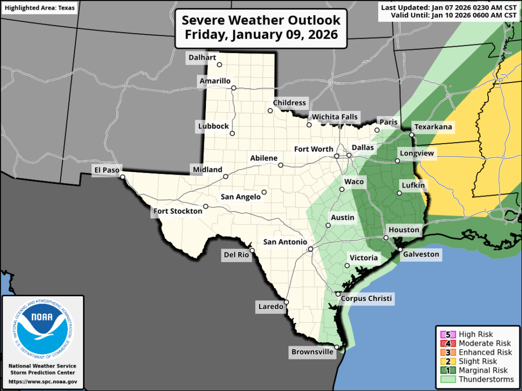
Houston’s weather has been mostly calm for awhile now, beyond the very warm conditions we have experienced since early December. However there is a slight chance of some severe weather on Friday night as a fairly robust cold front passes through. We will have a decent amount of shear available, but I just don’t think the overall background conditions will favor widespread, severe weather. So yes, some scattered thunderstorms are likely on Friday night (perhaps around midnight in central Houston), but I don’t expect much more than that.
Severe weather outlook for Friday and Friday night. (NOAA)
Thursday
We’re experiencing less fog this morning across the region, and that’s largely due to more pronounced southerly winds. They’re currently blowing at 10 to 15 mph, and we may see some stronger gusts up to 30 mph this afternoon. Skies will be mostly cloudy, but since the air mass moving in from the south will be warm and muggy, I still expect some parts of our area to hit 80 degrees. A few scattered, and light showers will also be possible today. Lows tonight will be very warm for January, in the upper 60s.
Friday
Rain chances improve on Friday, likely to about 60 percent for most locations. We will probably see scattered showers during the daytime. It is possible that a more organized line of showers and thunderstorms will develop later on Friday evening, and pass through Houston during the overnight hours. We’ll see. Regardless, temperatures on Friday will be warm and muggy, likely pushing 80 degrees. By Saturday morning we should be in the mid-50s, with much drier air moving in.
Saturday
This will be a breezy, and much cooler day with temperatures reaching only about 60 degrees during the afternoon. Skies will be mostly cloudy as well, adding to the chill feeling. A chance of showers may linger during the morning hours. Gusty winds from the north may reach 25 mph, or perhaps even a bit higher, before calming some Saturday night. Lows will drop into the mid-40s in Houston, with cooler conditions for outlying areas.
Air temperature forecast for the start of the Houston Marathon. (Weather Bell)
Sunday
I was chatting yesterday with a friend and fellow runner, and we agreed that conditions for the Houston Marathon are the best they’ve been in memory. Start-line temperatures will be in the 40s, with a modest northerly wind (probably 10 mph). Humidity will be very low, with partly to mostly cloudy skies. Rain should not be a factor. And temperatures by late morning likely will still only be in the 50s. So now is the time to go for those personal records!
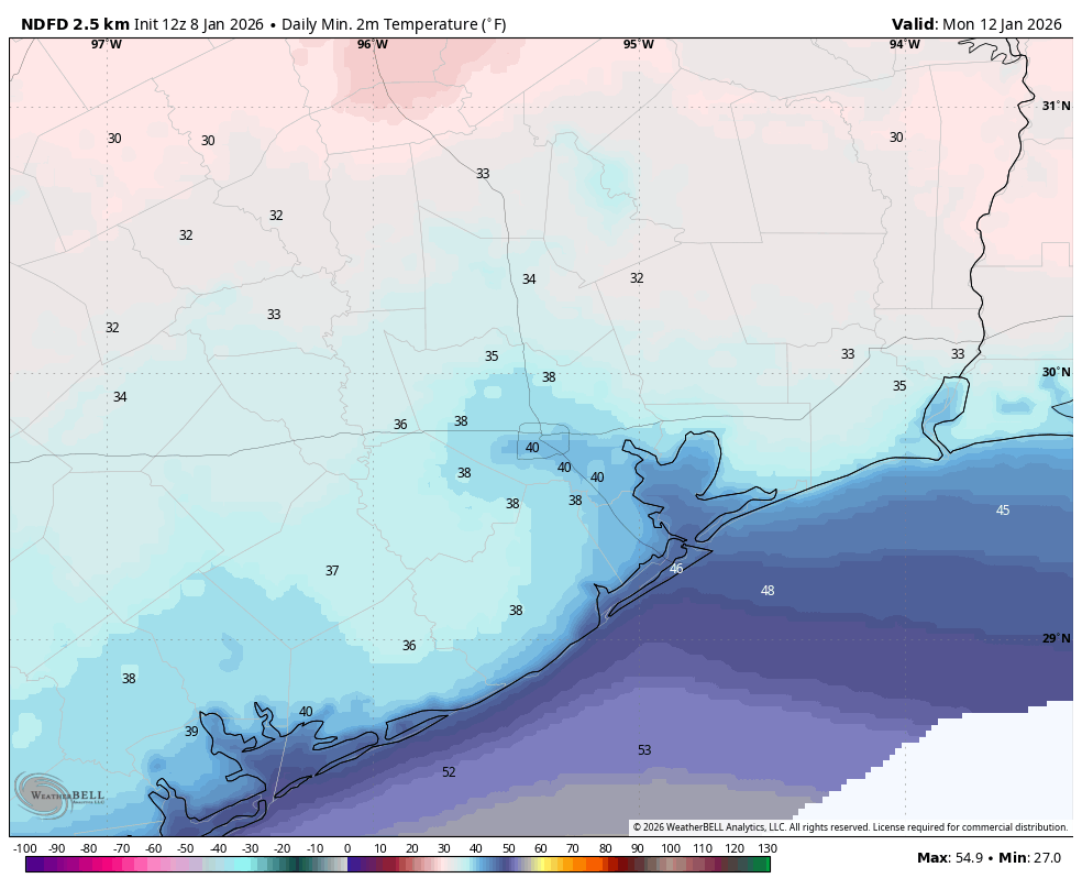
Anyway, for non-runners, we can expect highs by Sunday afternoon to reach about 60 degrees. Sunday night will be quite cold, with lows in Houston dropping to 40 degrees, with mid- to upper-30s for outlying areas. Far inland locations, such as College Station, Huntsville, and elsewhere may see a light freeze.
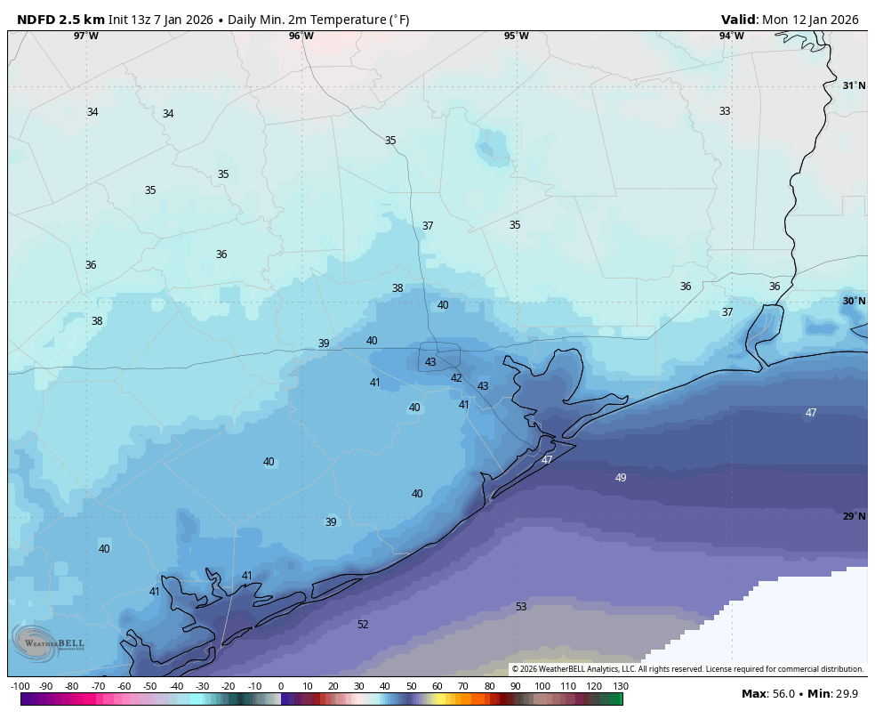
Low temperature forecast for Monday morning. (Weather Bell)
Next week
Winter should stick around through next week, with highs mostly in the 60s, and lows in the 40s. We may see some rain chances on Tuesday or Wednesday as a reinforcing front moves through, and then again next weekend. The details, as always, are fuzzy at such a distance.
In brief: In today’s post we note Tuesday’s record high temperature, and the potential for more today. We also discuss the possibility of thunderstorms on Friday and Friday night as a front pushes into the area. Following this front winter should stick around for awhile.
Record high update
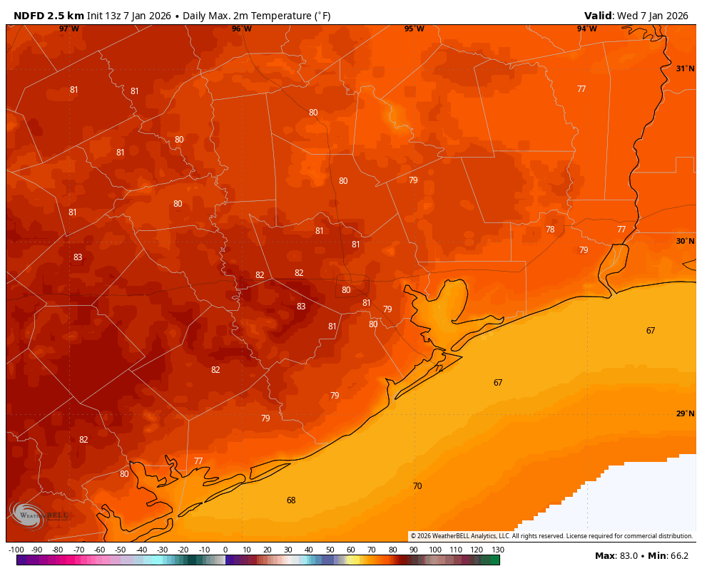
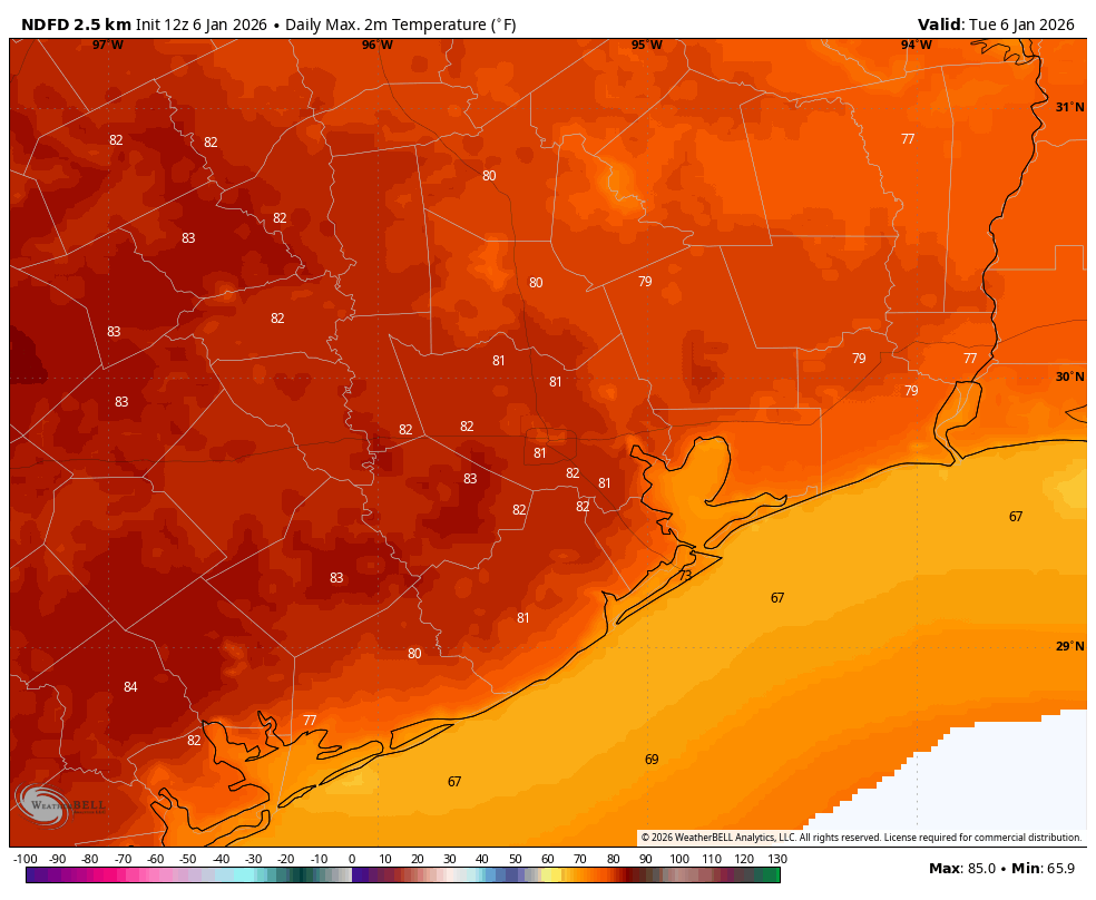
Houston has now set two record highs in 2026. On January 2, the high of 84 degrees broke the old record of 81 degrees, set in 1965 and 2000. And yesterday, January 6, the high of 82 degrees broke the previous mark of 80 degrees set in 1956 and 1989. Today will be close, with a forecast high about on par with the record of 81 degrees, set back in 2023.
Houston will have an 80s party today. (Weather Bell)
Wednesday
We are once again seeing fog this morning, as dewpoints and temperatures have both fallen into the mid-60s. These soupy conditions will be with us into Friday before a front pushes through. After the fog clears we should have mostly sunny skies later today with highs around 80 degrees. Winds will be light, generally from the southwest. Lows tonight will again only drop into the 60s, with mostly cloudy skies.
Thursday
This will be a cloudy and humid day, with highs ranging from the upper 70s to around 80 degrees for most locations. There will be a couple things of note. First of all winds will surge from the south in response to a nearby front, gusting up to 25 or perhaps even 30 mph. These winds will be highest on Thursday afternoon. We also will have a slight chance, perhaps 20 or 30 percent, of light rain during the afternoon and early evening hours. Thursday night will be warm and muggy again.
There is a marginal risk of severe weather on Friday night in the Houston region. (NOAA)
Friday and Friday night
We can’t say precisely what will happen Friday night, but generally I expect a warm and humid day, similar to Thursday with mostly cloudy skies. However, rain chances will be higher on Friday than Thursday, with scattered mostly light to moderate showers. There is also a chance for severe weather, primarily in the form of thunderstorms. This is most likely to occur between late evening on Friday and sunrise on Saturday, as the front itself moves into the Houston region. This is when we could see some briefly heavier rainfall. Most of our modeling is all over the place, but some locations could pick up 0.5 to 1 inch of rain whereas other locations see hundredths of an inch. We all need some rain, so good luck everyone.
Saturday
This will be mostly cloudy and cooler day, with a few showers possibly lingering during the morning hours. Temperatures at midnight will likely be in the 60s for most locations, falling to the 50s at sunrise and then staying there throughout the day. Skies will be mostly cloudy with modestly gusty northerly winds, perhaps up to 25 mph or so before ebbing during the late afternoon or early evening.
Sunday
Sunday morning will be cold. Start line temperatures at the Houston Marathon should be in the mid-40s, with dry air and mostly cloudy skies. Winds will be from the north at 5 to 10 mph, with slightly higher gusts. Rain chances are basically zero. Highs will likely climb into the upper 50s for most locations on Sunday afternoon. Sunday night will be chilly, with lows falling to around 40 degrees for most of Houston, with cooler conditions still for inland areas. A freeze is very unlikely, however.
Low temperature forecast for Monday morning. (Weather Bell)
Next week
Houston will feel like winter next week with highs generally in the 60s and lows mostly in the low- to mid-40s for much of the week. Skies should be partly sunny most days, with low rain chances. This pattern should prevail through the middle of the month.
In brief: In today’s post we discuss the potential for setting daily high temperature records this week ahead of a front on Friday. There also will be some rain shower chances on Thursday and Friday. The weekend and next week still look much cooler, with near ideal conditions for the Houston Marathon on Sunday.
Heat records
Houston’s high temperature reached 79 degrees on Monday at Bush Intercontinental Airport, marking the beginning of a warmer period that will persist into Friday. The next four days all have a chance to set record highs, depending on the timing of a front on Friday. Here are the forecast highs for each day at Bush, along with the record high.
Tuesday: 81 degrees (80 degrees, 1989)
Wednesday: 81 degrees (81 degrees, 2023)
Thursday: 79 degrees (79 degrees, 2019)
Friday: 76 degrees (80 degrees, 1974)
By Friday a strong front will sweep into the area, dropping temperatures by about 20 degrees, and returning us to near normal conditions for early January. Although I know plenty of our readers like a warmer winter, it simply is not normal to have a stretch of 80-degree days in January, which is our coldest month of the year.
Tuesday’s high temperature forecast. (Weather Bell)
Tuesday and Wednesday
As dewpoints have risen and winds decreased, we are once again seeing the return of foggy conditions this morning. Such fog will be possible during nights and mornings from now through Friday morning. Dewpoints this morning are in the mid-60s, and that is where they will stay until the front arrives, so we are going to see fairly muggy conditions.
Highs today and Wednesday will be in the vicinity of 80 degrees, perhaps a little warmer for inland areas, and a little cooler right along the coast. Skies will be partly to mostly sunny during the daytime. Winds generally will be from the south, occasionally gusting up to 15 mph or so. Overnight lows will drop into the low- to mid-60s for most of the region.
Thursday
As an upper-level disturbance approaches, we could see some light, scattered showers on Thursday. But for the most part I think we’ll just see mostly cloudy skies. This could shave a couple of degrees of daytime highs, but it will still feel warm and humid outside. Thursday night will again be warm and humid as well, with a chance of fog developing.
Friday
At some point on Friday, perhaps between sunrise and around noon, a cold front will drop down from the northwest. We should have a better handle on the details in the next day or so, but it appears possible that a broken line of showers and thunderstorms may accompany the front. However, at this time I don’t think we are looking at anything particularly severe, and in terms of accumulations I doubt most locations see more than a tenth of an inch of rain, or two. But we’ll see. Daytime temperatures will depend on the timing of the front, but I suspect we’ll drop into the 60s during the afternoon, with lows Friday night falling to around 50 degrees, or lower.
Houston’s temperature’s fall off a cliff with the passage of a front on Friday. (Weather Bell)
Saturday and Sunday
The weekend will see partly to mostly cloudy skies, with a slight chance of showers on Saturday. Highs on Saturday and Sunday will likely top out at around 60 degrees, with overnight lows in the 40 to 45 degree range. Winds will be fairly brisk from the north on Saturday, perhaps up to 20 or 25 mph. However I expect these to die down a bit by Sunday morning (for the start of the Houston Marathon). Start-line temperatures in Houston will likely be in the 40 to 45 degree range, so chilly with a bit of a northerly breeze, but not outright cold, especially for long runs.
Next week
Most of next week looks to see near-normal conditions, with highs in the 60s and lows in the 40s. We may see some additional showers in the Tuesday timeframe. Temperatures could warm up a bit toward the following weekend, but that will depend on the timing of the next front.