In brief: With the most potent rain-making storms now moving offshore, we are returning to a Stage 1 flood alert for the entire Houston region. Heavy rainfall remains possible on Friday, although we don’t expect storms to be quite as organized as they were today.
Hi everyone. Just wanted to write a quick post to note that the atmosphere is pretty well worked over, and that the strongest line of storms has now moved mostly offshore. As a result of this, we expect a fairly quiet afternoon and evening in the Houston metro area. We still expect to see some light to moderate showers for a few more hours today, but the trend will be one toward gradual clearing of the area.
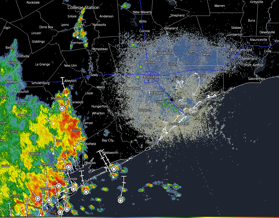
Houston radar image as of 11:54 am CT. (RadarScope)
If you’re looking for a bright spot, look no further than temperatures, which as of noon are hovering around 70 degrees for most of the region. We don’t see midday temperatures like this often in June. I expect highs to nudge upward, toward the upper 70s, before evening and slightly cooler overnight temperatures return.
I think conditions, in terms of rainfall, will generally be fairly calm overnight. However, by daybreak we may start to see some additional showers building in from the southwest, and we are likely to see another round of storms from the mid-morning through the afternoon hours across the region. I don’t believe these storms will be as widespread as today’s – in which some locations south and east of Houston picked up 6 inches – but the potential for heavy rainfall remains. We think a Stage 1 flood alert should cover us, but we’ll be keeping tabs on the situation just in case.
In brief: We have expanded a Stage 2 flood alert to cover the entire region today as a storm system passes through. The greatest likelihood of flooding appears to be to the southwest of Houston, but all areas will be vulnerable this morning.
Unfolding flooding event
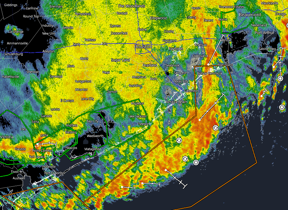
As we look at the radar this morning we have one band of persistent storms over eastern Houston which has dropped as much as 3 inches of rain over Channelview, Baytown, and other locations since midnight (a flash flood warning is in effect for these locations until 7:30 am today). Much of the rest of the region has been spared, but additional storms loom to the west of our area, and we expect the potential for flash flooding through about noon today. Not all areas will be affected, certainly, but please take care driving into stronger storms, and do not attempt to drive through high water.
Strong storms are firing up to the west of Houston and will move through this morning. (RadarScope)
The strongest storms should move into the Houston region during a time period from around 7 am to noon, after which the heaviest rains will likely reach the coast and begin to push off shore and well to the east of Houston. During this morning we now believe the heaviest rainfall will occur along and south of Interstate 10, and are particularly concerned about the southwest quadrant of the Houston metro area. Much of our modeling predicts that Wharton, Brazoria, and southern Fort Bend counties are at risk of picking up 5 to 10 inches of rainfall.
Closer to Houston, particularly within the city limits and to the east of Interstate 45, totals should be less. Generally, most locations should pick up 1 to 4 inches of rainfall, but there will be the potential for higher bullseyes. Given that this storm system has the ability to produce high rainfall rates, streets may back up quickly and flash flooding is possible. For this reason, we are expanding our Stage 2 flood alert to cover the entire Houston region, which includes all surrounding counties. We should be able to drop this flood alert back to Stage 1 this afternoon.
Thursday
As noted above, we are seeing an atmosphere laden with moisture interact with a potent disturbance this morning, creating favorable conditions for heavy rainfall. The strongest storms should end by noon, but some isolated showers could persist into this afternoon. As a result of the rain and cloud cover, high temperatures today should top out in the mid-80s. Lows tonight will drop into the 70s, with a slight chance of showers and storms.
Friday
Some additional storm development is likely on Friday, and conditions may be most favorable for this closer to the coast. However, we cannot be sure about this. Overall, the pattern is a little bit less supportive of strong storms on Friday, and I don’t expect things to be as widespread or significant as Thursday, but the threat of heavy rainfall will nevertheless be there. Highs will be around 90 degrees, as skies should be partly sunny.
Temperatures will return to the lower 90s in Houston by this weekend, with muggy nights. (Weather Bell)
Saturday and Sunday
The weekend will continue to see a chance of showers and thunderstorms, although at this point I expect them to be more isolated in nature rather than widespread. So they should be hit and miss, and there should be mostly sunny skies for much of the day. Expect high temperatures in the lower 90s. If you have outdoor plans, there’s a chance they may be fine, although you can expect soils and fields to be sodden from this week’s rains.
Next week
I expect this pattern to continue for much of next week, with a decent chance of showers and thunderstorms on a daily basis to go along with mostly sunny skies and high temperatures in the lower 90s. At this point I don’t see the potential for significant flooding, as these will more likely be passing showers driven by the sea breeze with lower accumulations. But we’ll see, as it is June, when we are prone to higher rainfall rates. I do expect a chance of rain to remain in our forecast for awhile, perhaps the rest of the month, rather than seeing a robust ridge of high pressure cover the area.
We will update this forecast as needed today. Please be safe in the wet and inclement weather.
In brief: Our confidence is increasing in the likelihood of heavy rain across the Houston metro area on Thursday morning, perhaps around sunrise or a few hours later. Flash flooding is possible in the strongest storms.
The overall forecast from the post we published this morning remains more or less on track. However, our confidence is now very high in impactful storms pushing into, and through, the entire Houston region on Thursday morning. Although we still have some questions about timing and placement, it is clear that a serious line of storms will go through.
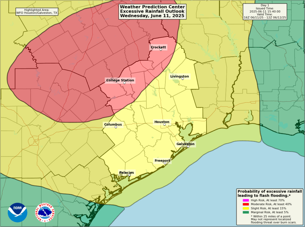
The Houston area faces a risk of excessive rainfall on Wednesday night and Thursday morning. (NOAA)
Tomorrow morning, before dawn, there may be some isolated or scattered showers and thunderstorms across the western half of the Houston metro area. However, the main event is likely to be a line of storms that forms northwest of the region and sweeps into the city. In terms of timing, we think this mass of storms will impact areas such as College Station around 5 am to 8 am, before pushing into central parts of the region (including the area inside Beltway-8/Sam Houston Tollway) between 8 am and noon. After this the line will likely continue down to the coast and exit the area to the east.
The models disagree on where the most impactful rains will be: Brazos County, Montgomery County, or Western Harris County are all possibilities, for example. But the bottom line is that we are going to mix a potent disturbance with an atmosphere with a lot of moisture. This is fertile environment for high rainfall rates, which can quickly back up streets and lead to flash flooding.
As a result of this we are elevating our flood alert to Stage 2 for areas along and west of Interstate 45.
Although we cannot entirely rule out other forms of severe weather, flooding is the main threat from these storms. Most of the region will likely pick up 1 to 4 inches of rain in a couple of hours, but there will almost certainly be higher bullseyes where 5 to 8 inches could fall in a very short period of time. In short, be prepared for disruptions to travel plans on Thursday morning, and be weather aware. We will have a full update for you early tomorrow morning.
In brief: Today and Thursday should bring the region our heaviest rains yet this month, with the potential for very high rainfall rates. We are concerned about the potential for street flooding, and have an ongoing Stage 1 flood alert for the entire region. We will monitor today for the need to escalate to Stage 2.
Overall pattern remains wet
The Houston region has experienced rounds of showers and thunderstorms on Monday and Tuesday of this week, but our confidence is increasing in the heaviest and most widespread rainfall arriving today and Thursday in the current pattern. It looks like the best chances for this will be during the morning hours on both days, so let’s dive in deeper to the forecast.
Wednesday and Thursday
Both of these days look to have a similar setup, and at this point probably will play out similarly. In the pre-dawn hours we will see a mass of storms develop to the west of the Houston metro area, and then this system will move through the city during the morning and early afternoon hours. In addition to the potential for heavy rainfall, especially on Wednesday there is the additional threat of damaging winds in Harris County and surrounding counties within stronger thunderstorms.
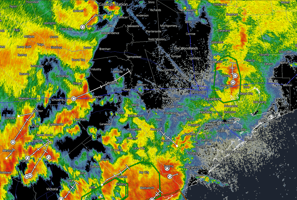
The Houston radar at 7 am CT shows a mass of storms to the southwest of Houston. They’re headed this way. (RadarScope)
This morning, looking at the radar, we can see a large cluster of storms to the southwest of Houston, near Matagorda Bay. High-resolution modeling indicates that this mass of storms will move to the northeast, pushing through the Houston region from 9 am to 3 pm. This is the period when we are most concerned about lightning, street flooding, and damaging winds. In terms of storms, our weather may turn more quiet later this afternoon and evening, but there will still be the possibility of some sporadic flare-ups.
Similarly, on Thursday, a mass of storms will likely congeal west of the Houston area after midnight and then move into the city during the morning hours. Whether this occur before dawn, or during the mid-morning hours, it is difficult to say right now. But the overall threat remains the same: heavy rainfall and flooded streets, with lesser odds of damaging winds and other severe weather.
In terms of rainfall totals, they’re going to vary widely. I believe most parts of Houston and surrounding areas will pick up 1 to 3 inches. However, in these kinds of storms in the past, at this time of year, we’ve seen very high rainfall rates. So it would not surprise me to see locations with 5+ inches of rain over the next two days. Matt and I will be watching closely for the need to escalate to Stage 2 on our flood scale. We’re not there yet, but we’re concerned about some of the high-end rainfall rates. We will, of course, update as needed.
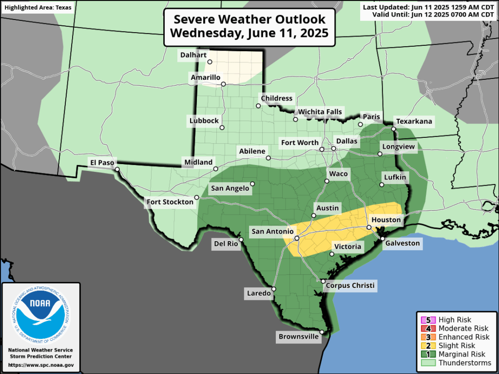
There will also be the threat of damaging winds with thunderstorms on Wednesday. (NOAA)
Mostly cloudy skies and rain-cooled air should keep temperatures in check over the next two days. I would anticipate highs in the upper 80s to possibly 90 degrees, with lots of humidity. Outside of thunderstorms winds should be fairly light. Nights will be warm and muggy.
Friday, Saturday, and Sunday
Each of these days will carry a healthy chance of rain showers, probably on the order of 50 percent or higher. But as of now we don’t see storms being quite as organized or intense—think pop-up storms rather than large systems moving through. As a result outdoor activities will probably be hit or miss. Days will see a mix of clouds and sunshine, and high temperatures will probably get into the lower 90s for the most part.
Next week
The pattern described above for this weekend should persist into Tuesday or Wednesday of next week: warm, muggy, with a solid chance of showers but probably nothing on the order of flooding. The second half of the weekend could go two ways: clearing skies and higher temperatures, or an ongoing wet pattern. I just don’t have enough confidence to predict one outcome or another.
A Galveston hurricane?
My daughters inform me that, on TikTok, “everyone” is talking about the possibility of a hurricane or tropical storm hitting Galveston next week. I won’t rule anything out during the Atlantic hurricane season, but suffice it to say in the world I live in, there is no model support for any such idea. So, probably not. I’m sure there is great weather forecasting on TikTok, but apparently the algorithm is feeding slop. Caveat emptor.