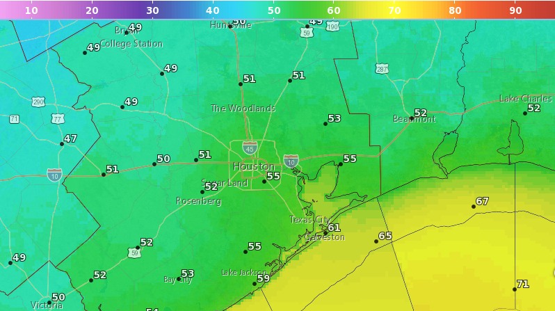
Oh, what a morning. Lows for some inland areas have fallen below 50 degrees, and all but areas hard by the coast have fallen at least into the upper 50s this morning. With dry air, and a crescent moon rising before the sun this morning, it was just about a perfect way to start the day. We’ve waited a long time for fall to arrive in Houston, but it sure feels great now that it has indeed moved in.
Oh, what a morning. (Weather Bell)
Tuesday
We can expect another perfect day across the region—we’ll see fewer winds today—as sunny skies allow high temperatures to reach about 80 degrees. Afterward, we can expect another cool evening and nighttime temperatures tonight a couple of degrees warmer than Monday night.
Sunday’s cold front certainly took its sweet time moving through Houston—the city tied a record high with 92 degrees, and Galveston broke its record high of 91 degrees—but cooler and drier air did finally blow through during the afternoon and early evening hours. And it’s everything we’d hoped it would be, strong enough, and lasting long enough, that we’re declaring this Fall Day for 2017 in Houston.
Monday
It’s been a breezy night, especially along the coast, as the front has pushed deep into the Gulf of Mexico. These winds should die down later this morning, although some gusts in the low 20s are possible throughout the day. Look for highs in the upper 70s this afternoon under sunny skies. Temperatures tonight will be pleasant for fall, ranging from around 50 degrees well north in Houston, into the mid-50s for much of Houston, and upper 50s closer to the coast. It’s going to feel, dare I say it, almost cold?
Houston’s forecast remains more or less on track: We’ll have three more hot, summer-like days before a cold front arrives later on Sunday. This front should be strong enough such that we’re calling Monday “Fall Day,” for the real beginning of fall-like weather in Houston.
Today
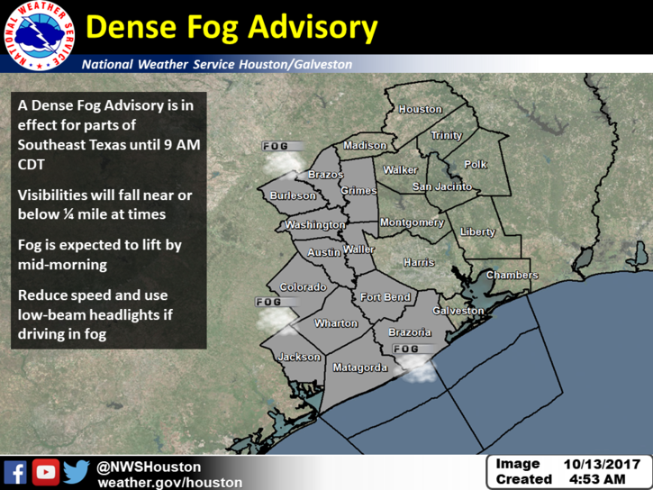
Low-level clouds have developed across much of the Brazos Valley this morning, and are extending into the western and parts of the central Houston area. This has led the National Weather Service to issue a “Dense Fog Advisory” for the western half of the metro area through 9am this morning. The rising sun should burn the clouds off, and this will give way to a warm, sunny, and muggy day with highs of around 90 degrees.
A fog advisory is in effect through 9am Friday. (National Weather Service)
Saturday
Another day like Friday, with some fog possible in the morning before a very warm and sunny day with highs again near 90 degrees. The record high for Saturday, 92 degrees, is not entirely out of reach.
After a cool start this morning, the Houston region will go right back into the late-summer-like weather we experienced for most of September and the first 10 days of October. However, we’re not going to have to wait as long for relief this time, with a second, stronger cold front arriving early next week. The coming front, in our view, signals the start of “fall” in Houston, so much so that we’re declaring Monday to be a new holiday—”Fall Day.”
Thursday, Friday, and Saturday
Southeasterly winds return, and as the Sun comes up on Thursday, so too will temperatures. Look for highs during the next few days to reach around 90 degrees. Rain chances will be near zero on Thursday and Friday, but some slight chances return on Saturday afternoon and evening. We don’t think most of you will see rain.
Sunday
Sunday should still be pretty warm, but our next cool front will march through the region during the midday, afternoon, or evening hours. I don’t think the cool air will be particularly noticeable with the sunny skies during the daytime, but drier air should work its way into the region during the overnight hours.
The GFS model shows the cold front near Houston on Sunday evening. (Weather Bell)
As for rain, we might see some scattered showers as the front works through, and in its aftermath, but again they don’t appear to be anything to write home about.