Intercontinental Airport reached 86 degrees, breaking the old record of 80 degrees
Hobby Airport reached 85 degrees, breaking the record of 82 degrees
Galveston reached 80 degrees, breaking the record of 76 degrees
It was the earliest 80 degree day for Galveston on record, breaking the previous record by two weeks—Feb. 21 set back in 1993.
There’s more to come today before we cool down a bit for the west of the week.
Today
Some dense fog along the coast will give way this morning to a mostly sunny—and for February, extremely warm—day. The earliest 90-degree day on record in Houston is Feb. 20 (1986), and while I don’t think we’ll reach 90 degrees, I’m not entirely ruling it given what happened Tuesday. Highs should be in the mid-80s regardless before a cool front arrives sometime this afternoon, pushing lows on Thursday morning into the 50s.
The GFS model predicts a front will push into northwest Houston by around noon today. (Weather Bell)
After Houston reached 81 degrees on Monday (tying a record high set in 1911), the city has now recorded 12 days with high temperatures of 80 degrees, or warmer, this winter. According to the National Weather Service, the record for total number of 80-degree days in “winter,” defined here as December through February, is 17, which has happened three times (1995-96, 1956-57, & 1910-11). We’re likely to pick up at least two more 80-degree days this week, so that will put us at 14. I’d give us even odds of breaking the overall mark.
Tuesday and Wednesday
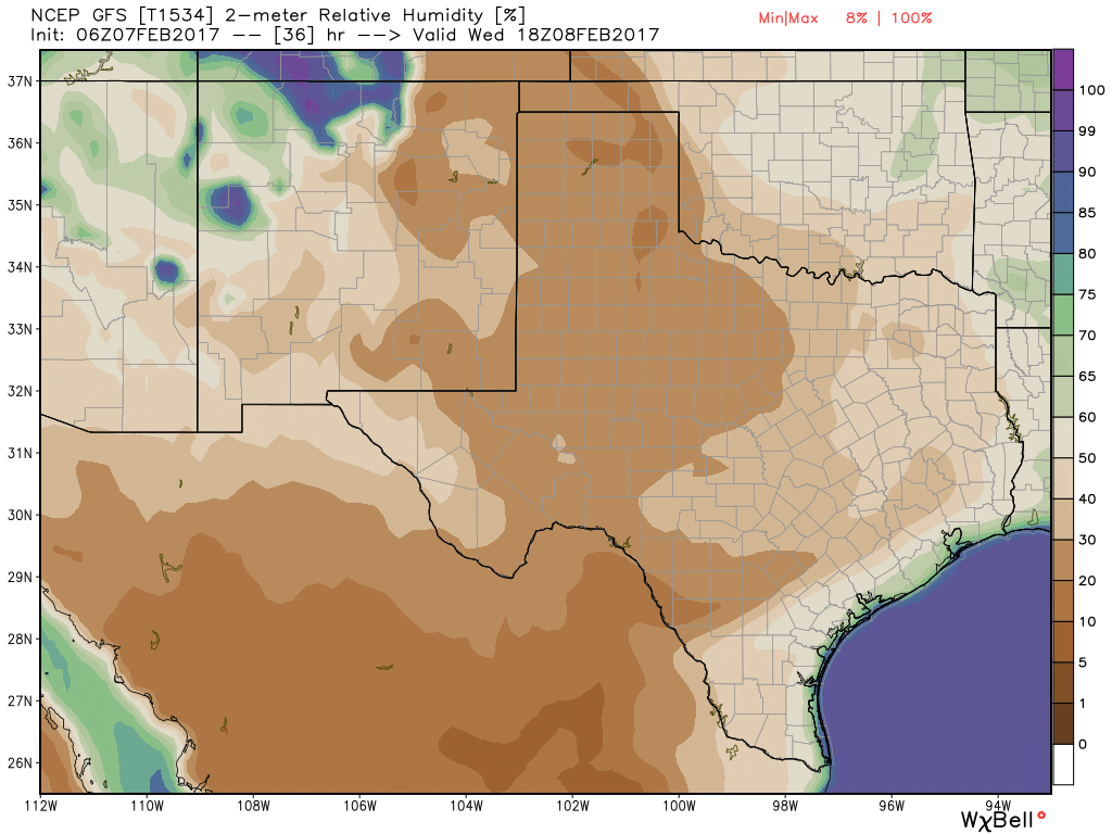
If you liked “winter” on Monday in Houston, you’re going to love the next two days. A strong southwesterly flow of warm, dry air from Mexico will bring a surge of winter heat into the region.
Expect drier, less humid air today and Wednesday across most of Texas. (Weather Bell)
I’m anticipating high temperatures of around 85 degrees on both days, with partly to mostly sunny skies. Lows will fall to around 60 degrees. As drier air mixes down, fire conditions will increase so take care of sparks.
It’s yet another one of these non-winter mornings across Houston, with low temperatures of around 70 degrees. It’s enough to make one wonder whether the region will get through this winter without a prolonged cold spell, and I’m increasingly confident the answer is yes. We might be done with freezes, as well.
For most of central and southern Houston and Harris County, the average last freeze date falls in mid-February. It’s not going to freeze again before then, and by extension I’d be confident in planting from here on forward. For areas north of there, including Montgomery County, the freeze date is generally later, in the latter part of February or early March. Even so, I’d bet the chances of another freeze for the greater Houston metro area this year, including areas like Montgomery County, is now significantly less than 50 percent.
Finally, here’s a tidbit about Dallas’ winter from Victor Murphy, of the National Weather Service—February 5 is date of the earliest last freeze in Dallas-Fort Worth. The average date of the last freeze is March 13. It’s possible this year that the city’s last freeze of winter will have come all the way back on January 8th.
It feels more like April or May out there this morning, with lows in the mid- to upper-60s across the region and fairly humid air. Some dense fog has formed. However a front moving through will bring some cooler weather with it later today, making it feel more like February.
Today
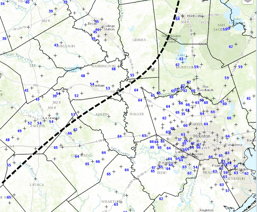
As of 6:30am CT, the front is still about 20 miles to the west-northwest of Harris County, but it should reach most of the area by around noon today. Expect mostly cloudy skies with some scattered light rain showers this morning and early afternoon, and temperatures tonight should fall into the low to mid-50s as the front packs a little bit more of a cooling punch than previously anticipated.
Location of the cool front as of 6:30am CT on Thursday. (Space City Weather/National Weather Service)
Friday and Saturday
A couple days of north and northeasterly winds will make for a slightly cooler end of the week, with mostly cloudy skies and highs in the mid-60s. Some very light rain will be possible both days, but accumulations will be nothing to write home about. Saturday morning could drop into the upper 40s for some inland areas north of Interstate 10.
The front’s brief reprieve will probably start to wear off by Saturday evening, or so, as warmer and more moist air returns. Look for highs in the low- to mid-70s during the day and run up to the start of the Super Bowl. Some of the latest forecast models have indicated at a decent chance of sprinkles during the day on Sunday—with accumulations of less than a tenth of an inch—but this might be just enough to force the closure of NRG Stadium’s roof.
Next week
This warmer pattern with a chance of light rain will continue from Sunday through next Tuesday or Wednesday, and it’s entirely possible that we’ll hit 80 degrees on one of those days. A front will probably arrive on Wednesday or Thursday, dropping temperatures back toward seasonal norms, with highs in the upper 60s, and lows somewhere in the 40s.
A lot of people have asked about freezes and planting. I am pretty confident that areas south of Interstate 10 have seen their last freeze for the season, however, it is simply too early in the year to make such a pronouncement for inland areas. I do not expect any freezes for the metro Houston area through the first half of February, however.