Summer really sets in this week for Houston, so let’s talk about the best way to measure heat

In brief: Houston will experience full-on summer conditions this week with hot days, mostly sunny skies, and sultry nights. To better characterize this heat, we will start using wet bulb globe temperatures more, and we explain them in today’s post.

Wet bulb globe temperatures

As we get into the heart of summer—and yes, that’s just what we’re in for during the next 80 days or so—it’s useful to talk “wet bulb globe temperatures.” Now this is a confusing name, and it’s not a simple calculation. To derive a wet bulb globe temperature, one need take three different measurements: air temperature (with a thermometer), mean radiant temperature (with a black globe thermometer), and natural wet-bulb temperature (a water-soaked thermometer). Like I said, it’s complicated.

However, interpreting a wet bulb globe temperature is easy, and we’re going to use it a lot this summer on Space City Weather. Quite simply, it is a measure of how heat affects you: it factors in temperature, humidity, wind speed, sun angle and cloud cover. It differs from the heat index, which is less precise. Using this metric is especially useful if you’re going to be outdoors, and not beneath shade. Basically, “high” temperatures are very warm, and “extreme” levels are borderline intolerable unless you’re in a swimming pool. Note that last year, during this week, we were already at “extreme” heat levels. This year we’re not quite that hot, but it’s still going to be very warm.

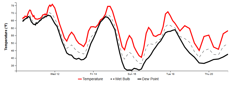
Wet bulb globe temperatures in Houston for the week ahead. (Weather Bell)

Monday

Our weather this week will largely be dominated by high pressure, which will lead to mostly sunny days and highs generally in the mid-90s, with some inland locations reaching the upper-90s. There is plenty of moisture in the atmosphere, but a capping inversion is going to be difficult to break most days. However, I do think areas south of Interstate 10 and closer to the coast have a better chance of seeing some spotty afternoon showers along the seabreeze this week. I’d peg daily chances at 10 to 20 percent, with lesser odds for inland areas. Overnight lows will be sultry, with temperatures only briefly dropping below 80 degrees in Houston, if they do at all.

Tuesday, Wednesday, Thursday

More of the same: Mostly sunny days, highs in the mid- to upper-90s, some isolated seabreeze showers, and warm nights. Winds will generally be from the southeast at 10 mph, with gusts up to 15 mph.

Rain chances this week? Not good. (Weather Bell)

Friday, Saturday, and Sunday

The forecast remains more or less the same for the weekend: mostly sunny and hot. I do think rain chances may bump up slightly into the 20 to 30 percent range, but I want to see how the forecast evolves for high pressure. Will it give a bit, or will it be relentless? We shall see.

Tropics

After the formation of Tropical Storm Alberto last week in the southern Gulf of Mexico, and a couple other disturbances, it looks like the tropics will go into quiescent mode for awhile now. This is perfectly normal for June, which is but an appetizer for the tropical main course, which comes in August and September for Texas.

Yesterday was the longest day of the year, so why is this not the peak of summer?

In brief: The Sun has reached its highest point in the sky, so why is this not the warmest time of summer? We explain. Also, we take a look at a forecast that includes rising temperatures and reduced rain chances. Beginning Sunday or so, it looks like we’ll be in the mid-90s for awhile.

Summer solstice

Thursday was the longest day of the year in the Northern Hemisphere—but only just. The Sun reached its highest point in the sky over Houston, a peak altitude above 84 degrees, at 1:23 pm CT. The time from sunrise to sunset was 14 hours, 3 minutes, and 31 seconds. Today will be one whole whopping second shorter. But for the next six months our days will progressively get shorter, until the winter solstice on December 21, when the day length will be just 10 hours, 14 minutes, and 2 seconds.

On of the quirks of Texas’ weather is that, while the Sun reaches the highest point of the sky in June, our hottest weather does not come until nearly two months later, in early- to mid-August. This is not true for all of the northern hemisphere, but there is a decided lag in Texas peak heating due to a number of factors. These include weather patterns (pervasive high pressure systems are more common in August than June), and a lag in ocean heating that brings the warmest onshore flows from the Gulf of Mexico later in the summer. Essentially, it takes longer for the ocean to heat up than it does the land.

Climatological midpoint of summer. (Brian Brettschneider)

The bottom line is that, even as our days get shorter over the next two months, on average our temperatures will continue to go up. Summer has not peaked in Houston, my friends. Fortify yourselves, because it has only just begun.

Friday

With Tropical Storm Alberto dissipating over Mexico, our seas are beginning to recede and winds have died down. Any lingering coastal flooding concerns should completely subside by this evening. Winds today will be generally from the east, at 5 to 10 mph. What about rain chances? I expect to see the development of some spotty showers later this afternoon. These will be more likely south of I-10, but even then overall chances are low, perhaps 20 or 30 percent. Skies, otherwise, should be partly to mostly sunny with highs of around 90 degrees. Lows tonight will be in the upper 70s.

Saturday

Expect sunny skies, with highs in the low- to mid-90s. Winds will be light, from the east. This will be a great day for outdoor activities, especially those that involve water of some sort. With the Sun high in the sky, please be sure and protect your skin.

Houston is marching into “high” heat levels based on the Wet Bulb Globe Temperature, a useful measurement of heat impacts. (Weather Bell)

Sunday

Skies should again be sunny, with highs generally in the mid-90s. There will be a smattering of rain chances, perhaps on the order of 20 percent. But most of us should remain dry.

Next week

You may have noticed that the National Hurricane Center has highlighted an area in the southern Gulf of Mexico where yet another tropical depression or storm may form during the next several days. This is almost exactly where Alberto formed, but we are not overly concerned this time. Why? Because this system is likely to be smaller than Alberto, so the upper Texas coast will probably see considerably less wind and less coastal flooding. Moreover, with high pressure building over the southern United States, it’s not clear how much, if any, precipitation we’ll see from this second tropical system.

Tropical outlook for Friday morning. (National Hurricane Center)

What all of this means is that, for most of next week, Houston is likely to see mostly sunny skies and daytime temperatures in the mid-90s. There will be some daily rain chances, perhaps on the order of 30 percent with the afternoon seabreeze, but I’m not expecting anything too organized. Rain chances may inch up a bit next weekend, but we’ll have to see about that.

Have a great weekend, everyone. After a busy spell, I’m looking forward to not writing about the weather for a couple of days!

As Houston’s weather settles down, how did the new AI models do with Tropical Storm Alberto?

In brief: Tropical Storm Alberto is about to move inland into Mexico, ending the threat of tropical rainfall across the Houston metro area. However, we are still likely to see at least some scattered showers and thunderstorms for several days—mostly passing downpours. After a few days with highs around 90 degrees, we’ll start to warm up this weekend into the low- to mid-90s.

How did the new AI models do?

Recently, I mentioned that Matt and I were assessing the value of relatively new weather forecast models, which are based in machine learning. These AI-based models have been ‘trained’ on historical datasets and have shown some promise in limited testing. They’re now starting to become publicly available in real-time, and we’ll be using them for the Atlantic hurricane season. (You can find some of them here).

Anyway, the evolution of Alberto offered the season’s first test. Last Friday, the models offered a distinct difference in forecasts. The majority of traditional, physics based models that crunch through complex physical equations to reproduce the atmosphere, produced a system that remained largely in the Southern Gulf of Mexico. I saved the output from the U.S.-based Global Forecast System model that was initialized on Friday morning. Here is its five-day forecast for the morning of Wednesday, June 19:

Output from the GFS model. (Weather Bell)

At the same time, the AI-based version of the European model, or AIFS, had for several runs been bringing Alberto much further north, toward the central Texas coast. This is what the output from the model, initialized at the same time as the GFS model shown above, looked like for Wednesday, June 19:

Output from the AIFS models. (Weather Bell)

That is a lot different, and certainly would have been more eye-popping for the Houston area. I frequently appear on the Houston Matters radio program with Craig Cohen, and we discussed this difference in output at the time. I told him it would be a good test. Five days later, on Wednesday morning, here’s where the tropical system, which had just formed as Tropical Storm Alberto, was:

Where Tropical Storm Alberto ultimately developed at that time. (National Hurricane Center)

As you can see, the physics-based GFS model was spot on, whereas the AI-based model misfired. This was not universally true, but the majority of physics-based models were much closer on track accuracy, whereas the AI-based models tended to have a more northerly track for Alberto (Huawei’s Pangu model was a notable exception, nailing the position). In our forecasts at Space City Weather, we relied on the physics-based models since they seemed more in-line with the overall atmospheric setup.

That’s track. None of the models did a great job with precipitation. There were several runs where the GFS model splashed 25 inches of rainfall over Houston, and the AI models that have rainfall outputs were also considerably more bullish than what Houston ultimately experienced. In any case, it’s going to be a long hurricane season. One test case proves nothing, but nevertheless I thought it was interesting to share.

Thursday

After coastal waters rose fairly high on Wednesday, due to the winds and surge of Alberto, they’re starting to recede some this morning. They’ll become less and less of a problem today and tonight now that the tropical system is inland. We’ll still see some gusty winds from the east today, perhaps up to 25 mph, but they’ll also be less than those of Wednesday.

In terms of precipitation, showers will be considerably more scattered today after much of Houston picked up 1 to 2 inches of rainfall on Wednesday. The most likely time for showers will be this afternoon, but they could come at any time, especially for coastal areas. Skies will turn partly sunny this afternoon, with highs of about 90 degrees. Lows tonight will drop into the mid-70s.

Friday

Another partly sunny day, with perhaps a 30 to 50 percent chance of showers and thunderstorms. Most of this activity will be fleeting. Highs will be around 90 degrees, with lows again in the mid-70s.

Saturday

Skies should be mostly sunny, with highs in the low- to mid-90s. Rain chances will be much lower, perhaps on the order of 10 percent.

Temperatures will be fairly normal for June during the next week. (Weather Bell)

Sunday and beyond

Our weather for next week is a bit uncertain due to the development of another tropical disturbance in the Southern Gulf of Mexico. However, this system is likely to be smaller, with lesser impacts. As a result I don’t think we’ll see nearly the winds and high seas we experienced from Alberto. Rather, for Sunday and most of next week, I expect we’ll see partly to mostly sunny skies, highs in the low- to mid-90s, and a decent daily chance of showers as tropical moisture pushes in from the Gulf. At this time there is no clear threat of heavy rainfall. So the weather looks pretty typical for late June.

Tropical system lashing the Texas coast, but Houston is missing most of the action

In brief: A tropical system is bringing heavy rains and lashing winds to the Texas coast this morning, but most of this activity is south of Houston. We’ll see the potential for widespread showers on Wednesday before lesser rain chances through the weekend. Houston’s skies will turn partly sunny starting Thursday, with lots of sunshine on Saturday and Sunday.

This water vapor image from Wednesday morning shows several features of note in the Gulf of Mexico. (NOAA)

Potential Tropical Cyclone One

A tropical system in the southern Gulf of Mexico is close to becoming a tropical depression, but it is running of time as it turns toward the east coast of Mexico. It should move inland by Thursday. Regardless of whether it develops further, the effects for Texas are baked in: elevated winds and seas, with the potential for heavy rainfall along much of the coast—but critically not the Houston region.

The light-to-moderate rainfall the city is experiencing this morning is basically the main thrust of the tropical moisture. Yes, this is it. In preceding days, we have been careful to balance expectations for this storm by suggesting there was a possibility that the heavy rainfall could go south of Houston, which it ultimately did. But there is no question our modeling whiffed badly on the risk of flooding in the Houston metro area. (Speaking of modeling, I’ll have a short analysis of the performance by AI models tomorrow on this tropical system).

The bottom line is that there is no longer any serious risk of flooding in the greater Houston metro area. To the south of the city, including areas such as southern Brazoria County, Bay City, and down into Matagorda Bay, there are notably higher rainfall totals and some risk of additional flooding today. These southern areas are also at risk of higher tides and coastal flooding, as well as wind gusts up to 40 mph.

Wednesday

The Houston region should see continued scattered light to moderate showers through the morning hours of the Juneteenth holiday. It’s possible that an additional, broken “band” of showers could develop over Houston this afternoon or evening. However, I don’t anticipate any of this rain leading to serious flooding issues. For the most part, these should be nuisance showers.

Winds associated with the tropical system in the southern Gulf should peak this afternoon over the Houston metro area, with gusts of 25 to 30 mph possible inland, and up to 40 mph along the coast, including Galveston Island. With elevated tides, some coastal flooding of low-lying areas is likely today, and again Thursday morning. Skies should be mostly cloudy today, limiting high temperatures to the 80s.

Thursday

As the tropical system moves into Mexico, it will cease to be a threat in terms of rainfall. As a result we are likely to see only scattered showers on Thursday with lesser accumulations. Skies will be partly sunny with highs of around 90 degrees.

Friday

Skies will be mostly sunny on Friday, with highs near 90 degrees. There will be a chance of showers and thunderstorms during the afternoon hours, but it likely is only about 30 percent.

Temperatures rise heading into the weekend. (Weather Bell)

Saturday and Sunday

The weekend should bring sunny weather with highs in the low 90s. Several readers have asked about a second tropical system, expected to develop in the southern Gulf of Mexico this weekend (see image at the top of this post). At this time I don’t expect it to have a significant impact on Houston’s weather, although it could drive some scattered showers and thunderstorms for coastal areas—that is, along and south of Interstate 10—this weekend. We’ll keep an eye on it, but for now it’s not something to be too concerned about.

Next week

Most of next week looks partly to mostly sunny, with highs in the low- to mid-90s. We may also see some afternoon, seabreeze-driven showers. All in all, the pattern looks fairly typical for late June as we march toward the heart of summer.