In brief: The forecast for this week is pretty boring, and unchanging. In fact, I give you permission not to check Space City Weather for a few days. We are going to be rather warm for February this week, with low rain chances. So this post addresses the question, is winter over?
Winter update
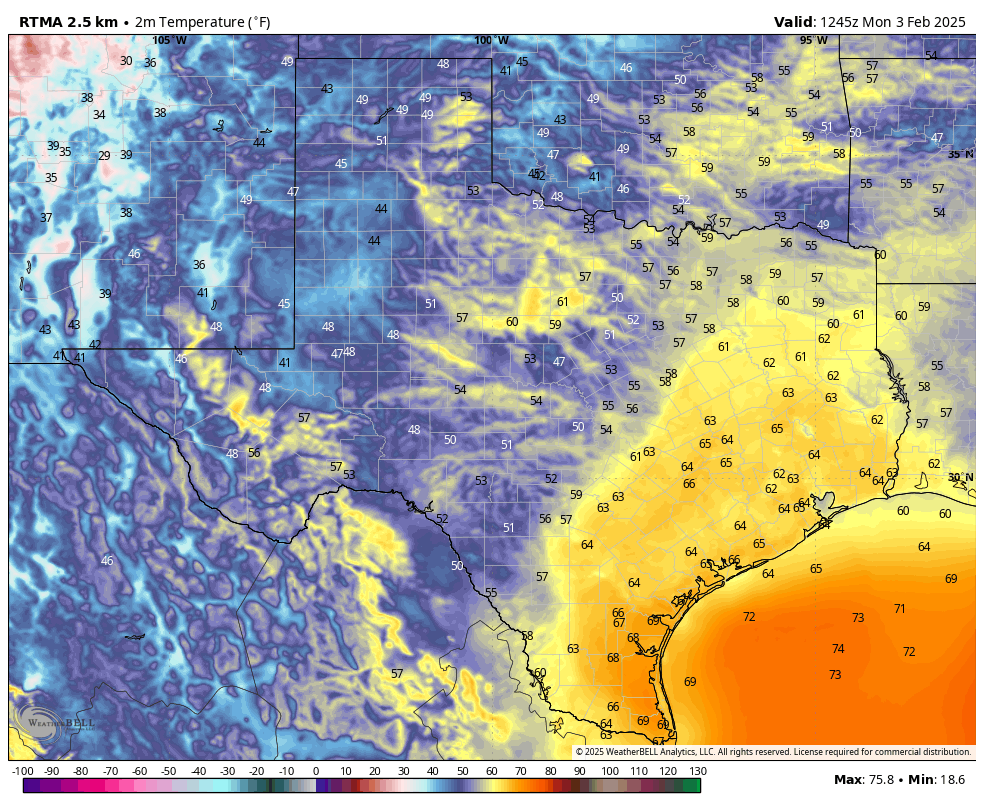
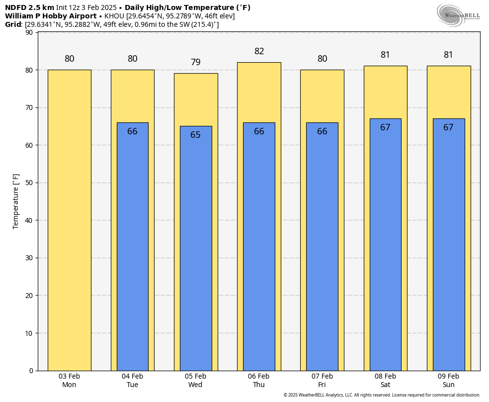
Sunday was gorgeous, and it felt much more like spring than winter. And the truth is, the entirety of the coming week is going to be quite warm with daytime temperatures around 80 degrees and mild nights in the 60s. So it is natural to ask, is that it for winter this year in Houston?
That depends. As the calendar goes, winter in Houston lasts from December through February. So we’ve got a few more weeks to go. Based upon the questionable prognostications from Punxsutawney Phil, who saw his shadow during a ceremony on Sunday, we have six more weeks of winter. But what does the science of meteorology say?
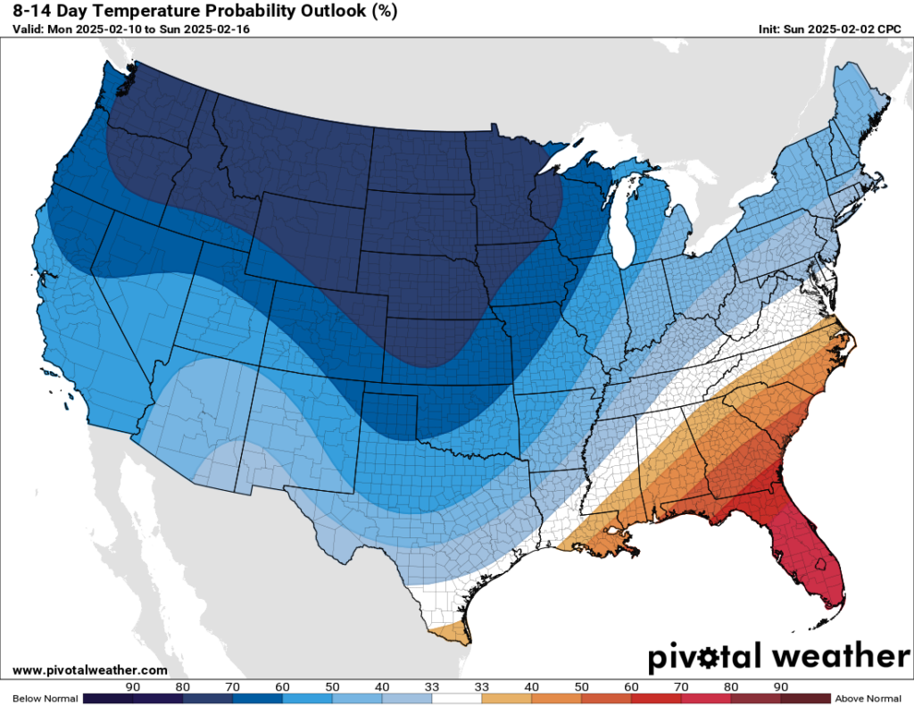
As usual, we have few absolute answers. However, it does seem clear that Houston’s pattern will turn colder next week. Moreover, there is the potential for another significant outbreak of colder air during the second half of February. This is because our latest data indicates that the stratospheric polar vortex, which bottles cold air near the north pole, may split and allow some of this very cold air to come down into the mid-latitudes. The timing for this would be later in February, or early March.
So our advice is that, yes, this week is going to feel unseasonably warm for February. It’s definitely shorts-and-t-shirts weather. But don’t put away those sweaters just yet.
Monday
Temperatures in Houston this morning are generally in the lower 60s, and this is as cold as our weather is going to get until next Sunday or Monday. This pattern is due to a persistent onshore flow, and it’s not going to vary much this week. This kind of warmer weather at this time of year is supportive of sea fog, so there will be a chance of that most mornings this week. Highs today will reach about 80 degrees, with partly sunny skies. Lows tonight will drop into the mid-60s.
Tuesday through Friday
Not much changes for the rest of the week. Expect partly sunny days, with highs of around 80 degrees, and cloudy nights in the 60s. There is perhaps a 10 percent chance of rain each day. Winds will be from the south each day at about 10 mph. With dewpoints in the 60s, it will feel moderately humid. And that’s basically the forecast. I should take a holiday.
Saturday and Sunday
The weekend looks more or less the same, with highs of around 80 degrees, lows in the upper 60s, and a mixture of clouds and sunshine. Southerly winds may pick up a little bit on Saturday from the south. At some point a front is going to come trundling through, but it’s not clear to me whether that will happen on Sunday, Monday, or Tuesday.
Next week
Whenever said front arrives it will probably bring our first meaningful rain chances with it. The front will also usher in winter-like conditions back to Houston, probably driving low temperatures down into the 40s during the second half of next week. But the timing and intensity of such a cold snap remains pretty fuzzy, as we’re talking about a period 7 to 10 days from now.