Houston likely to face showers this weekend as another front sags into the area

In brief: The region will heat up today and Friday, with moderately drier air in place. A combination of factors, including a slow-moving front, will bring elevated rain chances this weekend, particularly on Sunday. Slightly cooler weather will follow.

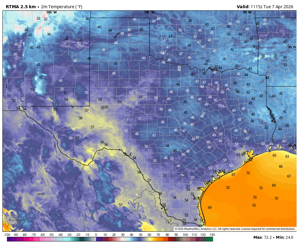
It is starting to look a little bit like fall across Texas this morning. (Weather Bell)

Thursday

A close look at the radar reveals a few showers right along the coast this morning—that’s the stalled front that has brought modestly cooler weather into the Houston region this morning. Lows at Conroe have dropped all the way into the mid-60s, but most of the metro area has settled into the low 70s. Because this dry air warms efficiently, and skies will be sunny, we will see highs today in the mid- to upper-90s for much of the region away from the coast. With dewpoints in the 60s this afternoon it will be a slightly drier heat, but it’s still going to be pretty hot. Winds will be light, from the west at about 5 mph. Lows tonight will be a couple of degrees warmer than this morning.

High temperature forecast for Thursday. (Weather Bell)

Friday

This will be another sunny and warm day, with highs in the mid-90s for much of the area. However, winds will turn more southerly, with gusts up to 15 or 20 mph, and this will herald the return of the onshore flow. This is one factor that will lead to higher rain chances over the weekend, but only one. Friday night will see lows drop into the upper 70s.

Saturday

The first half of the weekend will see a few more clouds in the sky, but there should be enough sunshine to help push temperatures for most into the vicinity of 90 degrees, or just above. Rain chances are about 40 percent, but for the most part I think any showers that develop will be light to moderate, and not super impactful. With ample humidity in place, look for a warm Saturday night.

Sunday

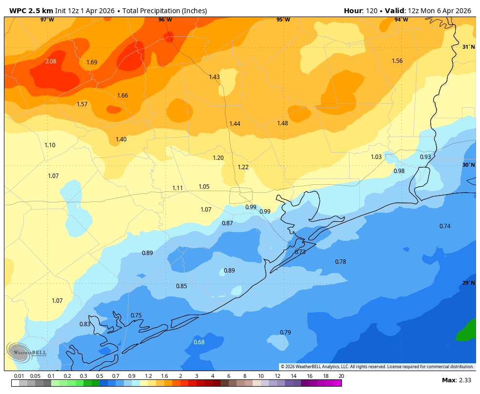
Rain chances will peak on Sunday, likely in the 60 to 80 percent range. Why? Because the combination of a front dropping down from the north, along with an influx of moisture from the remnants of Hurricane Lorena in the Pacific, should bring a healthy chance of showers across the area. We certainly cannot rule out the threat of heavy rainfall, but at this time I expect most of the region to pick up between 0.25 and 1 inch of rain this weekend, rather than seeing any significant flooding. But we’ll keep an eye on it. Highs, for the most part, should top out in the upper 80s.

NOAA rain accumulation forecast for now through Sunday. (Weather Bell)

Next week

At this point it looks like the front will drag into Houston on Sunday-ish, and stall out near the coast. Depending on where the front stops, we could see some lingering showers next week for coastal areas, or they should remain offshosre. Regardless, we should see a couple of days in the upper 80s to 90 degrees, with nights in the lower 70s. Some inland areas may drop into the upper 60s again, so pretty nice overall. Most of next week should be sunny.

Tropical outlook for Thursday morning. (National Hurricane Center)

Tropics

A disturbance progressing across the Atlantic is increasingly likely to become a tropical storm, and then possibly a hurricane over the course of the next week. There remains a ton of uncertainty about where this will ultimately go, and since it is early September we need to keep an eye on its development. However, overall the odds of this system affecting Texas look to be quite low at this time.

Hotter and sunnier for a few days before rain chances return this weekend with tropical moisture

In brief: In today’s post we talk about the impact of early season fronts along the Gulf coast, which are somewhat paradoxical. We also look ahead to increasing rain chances due to a front and potentially moisture from a tropical system in the Pacific Ocean.

The paradox of early season fronts

From a practical standpoint, it’s really a misnomer to call the first fronts of late summer and early fall “cold fronts.” In a strictly meteorological sense, they are. But when these early fronts usher in drier air and clearing skies (but not much cooler air) they make it more efficient for the lower atmosphere to heat up. And that’s what we are going to see over the next couple of days: sunshine, hottish days with lower humidity, and mild nights. In fact, some locations north and west of Harris County may dip into the upper 60s tonight. That is not “cold,” but it is a nice departure from very humid nights we’ve experienced since June. It’s also a foretaste of what is to come in a few weeks, when we should see some stronger fronts trundling down into the area.

Low temperature forecast for Wednesday night into Thursday morning. (Weather Bell)

Wednesday

As a slightly drier air mass moves into place today we will see highs, generally, in the mid-90s across the region. We cannot rule out a slight chance of showers for areas south of Interstate 10 later this afternoon, with daytime heating, but most of us should remain dry. Skies, otherwise, will be sunny with a light northwest wind in place. Lows tonight will drop into the low- to mid-70s in Houston, with cooler conditions in place for areas further inland.

Thursday and Friday

With a drier air mass in place we can expect sunny days with hot temperatures in the mid-90s in Houston, and upper-90s for areas further inland. Nights will drop into the 70s for most of the region. The air will be a little drier, but not crazily so.

Remnants of Lorena may help to increase our rain chances this weekend. (National Hurricane Center)

Saturday and Sunday

By later on Friday we should see the resumption of an onshore flow that will increase atmospheric moisture levels. This will generate some clouds, and lower daytime temperatures, likely in the lower 90s on Saturday and pushing us into the upper 80s on Sunday. There are a couple of things we just don’t know enough about that will drive rain chances and amounts this weekend. First up is a slow-moving front that will be pushing toward (and possibly into) the region. This will destabilize the atmosphere. The region may also see a surge of moisture from Hurricane Lorena, which is presently in the Eastern Pacific Ocean and will be moving into Mexico and West Texas this weekend. All of that to say, we will perhaps see rain chances in the vicinity of 40 percent on Saturday, and 60 percent or higher on Sunday. Something to monitor if you have plans this weekend.

Next week

Our weather next week will depend on whether the region sees any impacts from the aforementioned front. Generally I would expect highs in the vicinity of 90 degrees, with some lingering rain chances to start the week followed by a drier pattern. We’ll see!

Seven-day tropical outlook. (National Hurricane Center)

Atlantic Tropics

There’s a rather ominous looking red blob at the moment in the National Hurricane Center’s seven-day tropical outlook. At this point there is no clear guidance on where this storm will go, or how strong it will get. My general sense is that the odds of something making it into the Gulf from this system are fairly low, however. Head over to The Eyewall for all of the gory details.

August is over. So how did this summer stack up? The answer may surprise you.

In brief: Today’s post reviews the summer of 2025 in Houston. Some residents may believe this one felt cooler than is typical. We see what the data says about that. Additionally, we look ahead to this week’s weather in the wake of a front that finally pushed through over the weekend.

A review of summer 2025

August has come to an end. For most of us, in terms of weather at least, that is cause for celebration. Not because the kids are back in school, and teachers back at work. Not because summer vacation is over. But rather, because August is the hottest and most severe month for weather in Houston, and cooler conditions are on the horizon. September 1 also marks the start of meteorological fall, so it allows us to step back and ask, how hot was this summer?

My immediate reaction is that this summer felt fairly mild. There were no prolonged periods of high pressure and blazingly hot days. However, when we dig a little deeper, we find a different answer. Matt already wrote about this in one of our monthly Q&A’s, but this summer has been sneakily hot. When we look at the “average” temperature for June, July, and August of this year, we get a value of 86.0 degrees. This is simply the daily high, and daily low, divided by two for the last three months. It turns out this summer was the sixth hottest June, July, and August in nearly 150 years of Houston temperature records.

Top ten warmest summers on record in Houston. (NOAA)

You might say, well, it did not feel that hot. And you’re right, the days were not blistering hot. In terms of daily highs, our average of 94.9 degrees only ranked 12th on record in Houston. My sense is that summer days felt cooler because a) we had more clouds and periodic rainfall to help cool days off, and b) recent summers such as 2022 and 2023 were so incredibly hot that they have reset our expectations of normal. Where this summer was exceptionally hot, however, was at night, when the daily minimum temperature averaged 77.0 degrees. This is tied for second, all time, behind only 2023 (77.4 degrees).

So what’s going on here? Well, it’s complicated. Certainly the urban heat island effect (widespread sprawl and concrete, which absorbs more heat) is playing a role. But Galveston and College Station also recorded summers that ranked in the top 10, in terms of overall heat. So there is more happening in the background here. The main driver of our warmer nights is the Gulf, which greatly influences our nighttime temperatures. This is due in no small part to warmer oceanic temperatures around the planet. Our world is heating up, and in Houston we are experiencing that even during a “mild” summer.

Tuesday

Following widespread rainfall over the holiday weekend, showers this morning are mostly offshore after a weak front has moved into the area. I think we’ll still see a slight chance of rain later this morning (30 percent, maybe) for areas along and south of Interstate 10, but the trend is clear. We are going to see an influx of moderately drier air over the next couple of days. Skies today should be mostly sunny, with high temperatures in the vicinity of 90 degrees. Low temperatures tonight will drop into the mid-70s in the city, with slightly cooler temperatures possible for inland areas.

Low temperature forecast for Thursday morning. (Weather Bell)

Wednesday, Thursday, and Friday

These will be the driest days, which in early September means there still will be some humidity. Still, it should feel a little bit drier outside, with highs likely reaching the lower 90s in Houston, and mid-90s for some inland areas. Skies will be sunny, with virtually no chance of rain. I think Wednesday night into Thursday morning will see the “coolest” weather, with some inland locations potentially hitting the upper 60s. Obviously this is not cold, but the nights and mornings should feel a little bit more mild.

Saturday, Sunday, and beyond

Some time on Friday, probably, the pattern will change as the onshore flow returns. This will raise humidity levels and should give us a warmer night on Friday, and start to increase rain chances this weekend. At the same time another front will approach our area from the north. It is not entirely clear whether this front will push down into Houston and off the coast, or stall. But the bottom line is that we probably will go from highs in the low 90s on Saturday to the upper 80s on Sunday and Monday, with a decent chance (maybe 30 percent) of showers on Saturday and better chances on Sunday into early next week. I don’t think we’ll see a repeat of the heavy rains we experienced over Labor Day weekend, but I cannot be sure of that. Most of next week should see highs in the vicinity of 90 degrees.

Houston may see heavy rainfall on Sunday and Monday. We are issuing a Stage 1 flood alert

In brief: We interrupt your Labor Day weekend just to reinforce our messaging that widespread rainfall is likely today and Monday, and there is a risk of excessive rainfall particularly on Sunday. We are calling for a Stage 1 flood alert on our scale out of an abundance of caution.

A snapshot of Houston’s radar as of 10:51 am CT on Sunday. (RadarScope)

If we check the radar as of late morning on Sunday there is a large mass of showers and thunderstorms to the north of the Houston metro area, pretty much along and north of Highway 105, which runs through Conroe. These storms are slowly moving south and will have some impact on the Houston region today, although we still have some questions about how much.

The background factors are a slow-moving, or essentially stalled front that should sag down into the Houston region today. The atmosphere is already laden with moisture, and the front will provide a spark to generate precipitation. For these reasons we face the potential for heavy rainfall in our region today, and we are instituting a Stage 1 flood alert through Monday. This means there should be mostly minor flooding impacts, with the potential for frontage roads and low-lying streets to back up. Not everyone will see rain, and fewer still heavy rainfall.

My general sense is that the mass of storms to our north should mostly remain to the north. But there is certainly a risk of re-development over central or coastal parts of the region later today. The environment for Monday also should be favorable for additional showers and thunderstorms, although the potential for flooding appears to be slightly less. The bottom line is that, as you enjoy the Labor Day holiday weekend in Houston, please be weather aware, and keep an eye on the radar as you venture out and about.