In brief: The overall pattern remains the same, with a little more than one day of muggy and warm weather ahead of a cold front that will usher in much more seasonable weather. This front will bring cooler conditions for the rest of the week, and into early next week. However we’ll see a warming trend by Christmas Day next week, when conditions look to be fairly mild.
Tuesday
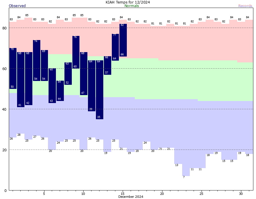
We’re starting out this morning with fairly widespread fog due to temperatures nearly matching dewpoints, and calm winds. It may persist for an hour or two after sunrise. After that, if you liked Monday’s weather, you’re in luck. Today will be similar, with high temperatures in the upper 70s to 80 degrees, and partly sunny skies. We’ll see a few isolated showers this afternoon, with the barest chance of a thunderstorm. Lows tonight will drop into the mid-60s, with partly cloudy skies. Expect the possibility of some fog again tonight and on Wednesday morning.

Wednesday
Houston will experience the same muggy pattern on Wednesday ahead of a cold front. The timing of the front is a bit uncertain still, but I expect a broken line of showers to advance into Houston from the northwest, perhaps reaching areas such as Katy and the Woodlands around noon-ish, and the coast during the late afternoon hours. Although the showers look to be hit or miss, the region will experience some fairly stiff northwesterly winds almost immediately with the front’s passage. Expect gusts up to 25 mph or so as drier air blows in. Temperatures should drop into the 50s after sunset, and most of the region away from the coast should drop into the upper 40s overnight as skies clear.
Thursday and Friday
These will be a pair of mostly sunny days with high temperatures generally in the mid-60s, and mostly light northerly winds. Thursday night should drop into the upper 40s, but Friday night looks colder with an additional surge of cooler air. Most of the region should drop to around 40 degrees, with some inland areas hitting the upper 30s.

Saturday and Sunday
Mostly sunny and cooler weather continues through the weekend. High temperatures on Saturday will top out at about 60 degrees, with another cold night, followed by mid-60s on Sunday, and a slightly warmer night. We have zero weather concerns about weather during the final weekend before Christmas.

Next week
We continue to expect to see a warming trend beginning next week, which will probably last at least through Christmas Day. There remains some uncertainty in the details, but my best guess for weather by next Wednesday is lows in the upper 50s, highs in the 70s, modest humidity, and partly sunny skies. It’s way too early to have any confidence in whether it will rain or not on the holiday, but it remains a possibility.