In brief: This post, also published on The Eyewall, reviews the 2024 Atlantic hurricane season which officially ended on Nov. 30. The season will likely be remembered for the Appalachian flood disaster due to Hurricane Helene, and the relatively quick follow through in Florida from Hurricane Milton. Locally, Hurricane Beryl caused significant disruptions due to its wind gusts.
Hurricane season ends today officially, although it’s been quiet for the last 10 days or so. We could still get a surprise, as offseason storms have occurred. The last wintertime tropical system was an unnamed storm in January of 2023 off the coast of New England. Hurricane Alex occurred back in January 2016 out in the middle of the Atlantic. An unnamed storm formed near the Azores in December of 2013. The 2007 Atlantic season continued into December with Tropical Storm Olga, which racked up $45 million in damage in the Caribbean.
To retire, or not retire, that is the question
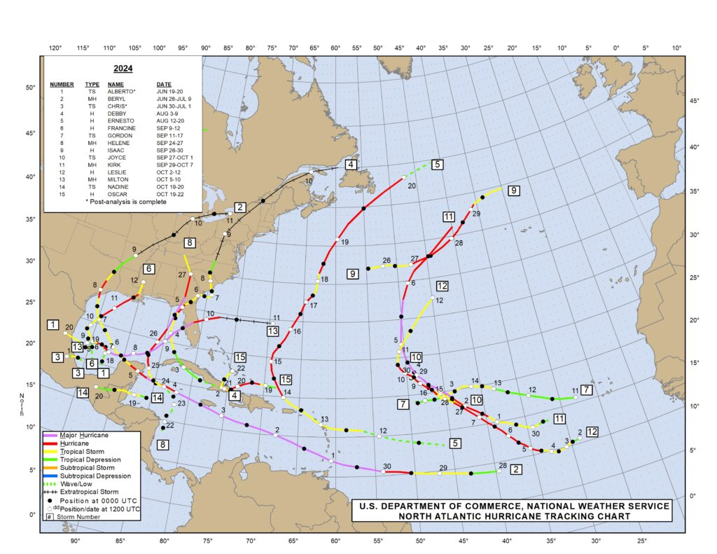
The 2024 Atlantic season will likely be remembered for the Appalachian flood disaster due to Hurricane Helene, as well as the relatively quick follow through in Florida from Hurricane Milton. Helene will almost certainly be retired in the post-season, the first “H” storm to get that treatment since 2017’s Hurricane Harvey. I suspect Milton will also be retired, which would make it the first “M” storm since Hurricane Michael in 2019 to be retired from the list.
The “B” storms are particularly tough to retire, given that they’re usually weaker and earlier in the season. The last “B” storm to be retired was 33 years ago, Hurricane Bob (which this author remembers from being sideswiped in New Jersey as a kid). Beryl will also almost certainly be retired, less so for what happened in Houston and more for what it did to some of the Caribbean islands as a category 5 storm.
The “A” storms are a bit easier to retire, with notable intense storms like Alicia, Allen, Andrew, Anita, and Audrey on the list. Flood events like Allison and Agnes have also been retired.
Storm names are generally retired because they were especially memorable or catastrophic in terms of property damage or loss of life. It’s part of why naming works for hurricanes; if it was an especially bad storm, that name will never be heard again except in relation to that specific storm.
The total damage from this season is likely to top $100 to 150 billion in damage based on various reliable estimates. There’s a much deeper story to be told here. Between various disasters and inflation in recent years, the cost of insurance has risen dramatically. This year likely did not help those problems. Folks like Steve Bowen below, as well as Kelly Hereid and Susan Crawford’s “Moving Day” are very good resources to follow this ongoing story.
How did seasonal forecasts fare?
Back in May, I described the upcoming hurricane season as likely to be an “arduous slog.” It ended up that way in the end, sort of, but a bizarrely silent August threw a massive wrench in forecast expectations this year. NOAA’s official hurricane outlook called for the following:
- 17 to 25 named storms (18 storms, just verified)
- 8 to 13 hurricanes (11, verified)
- 4 to 7 major hurricanes (5, verified)
- Accumulated cyclone energy (ACE) 150 to 245% of the median (About 120-125% of the 30 year average, fell somewhat short)
So overall this was a mixed bag of a seasonal forecast. There were some good calls and some overdone calls. In general, NOAA has actually had a bit of an under-forecast bias, with 4 of the last 5 years verifying above their forecast range.
- 2023: Forecast 14/7/3 and verified with 20/7/3
- 2022: Forecast 18/8/5 and verified with 14/8/2
- 2021: Forecast 17/8/4 and verified with 21/7/4
- 2020: Forecast 16/8/5 and verified 30/14/7
- 2019: Forecast 12/6/3 and verified 18/6/3
So, they met the target this year, though the ACE forecast was overdone. Much of this season’s absurdly high forecasts were driven by excessively warm water temperatures in the entire Atlantic basin, as well as the projected development of La Niña in the Pacific Ocean. The warm water temperatures held on all season.
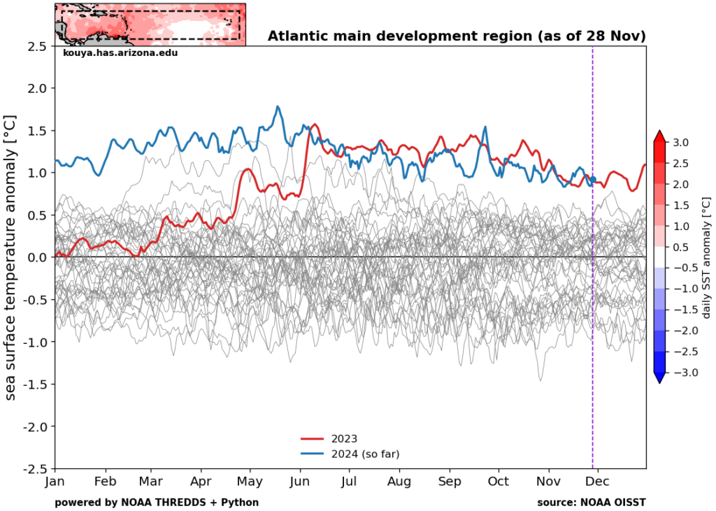
Notably for 2025, we remain near record levels across the Atlantic, except in the Gulf which has mercifully fallen back to just “above normal” levels. So the water temperature forecasts were accurate.
So what about La Niña?
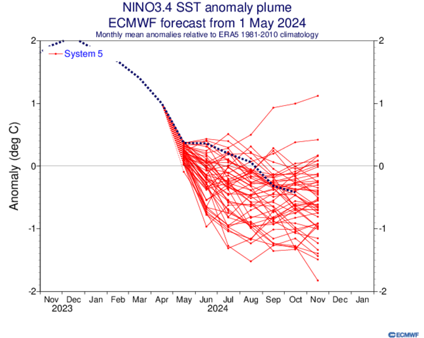
Well, this one is a bit more complicated, but the answer is that it partially verified, yes. The ensemble spread shown by the multiple members in red lines above did a nice job capturing the realistic spread in possible options. And through August, the La Niña seems to have struggled to develop. We seem to be getting there now, sort of, though we are not officially there yet and we may not officially get there. We’re basically ENSO neutral, leaning negative. So while the forecast technically verified within the plume, it did not get to La Niña, which probably had some impact on reducing potential storms.
What happened in August?
So what hurt August and why did this season “feel” like it really underachieved? Well, if we look at the variable of “velocity potential” as a proxy for “rising air,” where negative values (blue and purple) indicate more rising air than usual, we can see an interesting comparison to an active stretch like August 15 through September 15, 2020, which produced some hefty storms. Use the slider to see the differences.
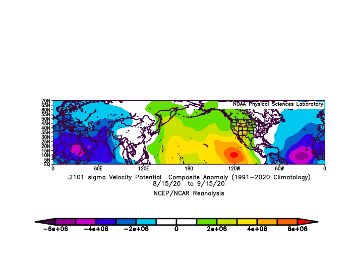
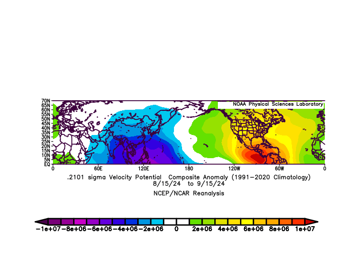
Both seasons featured generally significant rising air over Africa and/or the Indian Ocean, much like you would want to see in an active stretch. In 2020, however there was significant rising air over the Atlantic as well, whereas in 2024 we saw significant sinking air present in the Gulf, Caribbean, and parts of the western Atlantic. Interestingly, if you look at the rate of precipitation this year, you see a major difference in *where* in Africa the above normal rainfall occurred.
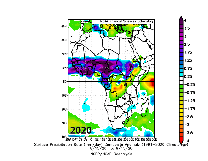
There was a good deal of talk this year about how the Sahara and Sahel were experiencing significant rainfall, and indeed there was a massive greening in the Sahel this year. Does this entirely explain why the 2024 Atlantic hurricane season was a bit less frenetic than expected? No, but it does offer a possible partial explanation and avenues for research that can help with future hurricane season outlooks.
Overall, there is a lot to unpack about this season. From a damage standpoint it met expectations. From a statistical standpoint, it met some expectations and fell short in others.
Fundraiser
You want to know what hasn’t ended? Our annual fundraiser at Space City Weather. However, it does tomorrow. So if you want to support our work here, please follow this link to donate or buy merchandise.