In brief: Invest 93L is kaput, and now we will look for some heavier downpours in spots today. Rain chances begin to dwindle on Saturday and Sunday as a hotter, less unsettled pattern establishes over our region for much of next week.
Today
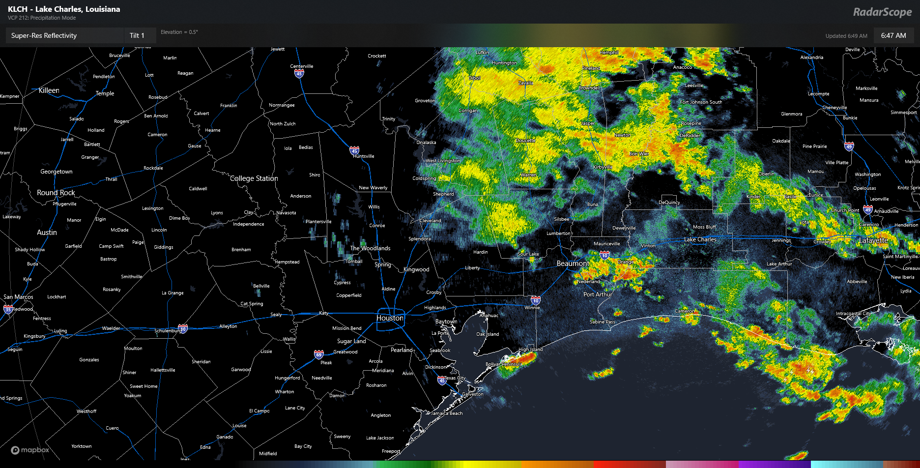
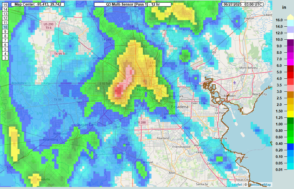
Our best chance of rain will come today. The radar as of early Friday morning shows widespread rain north of Liberty and in Louisiana. Additional, more isolated thunderstorms are popping up along I-10 near Beaumont and on the Bolivar Peninsula.
Radar as of 6:45 AM shows some coastal showers, heavier showers near Beaumont, and some steady light to moderate rain to the north. (RadarScope)
As we go through today, a lot of that steadier rain north of I-10 will probably dissipate. Even some of the thunderstorms this morning may fizzle. But a new round of scattered thunderstorms is likely this afternoon. For the most part, this will be like any other summer afternoon in Houston. Available atmospheric moisture will be a bit higher than usual though, so just be on the lookout for a downpour or two that could briefly flood streets in some parts of the city. Storms should fade after sunset.
Saturday
There should be a somewhat decent lingering shower chance here, but for the most part, any added moisture from the Invest 93L (RIP) would be exiting. I wouldn’t be floored to see a couple heavier downpours in the area though. Look for highs in the mid-90s.
Sunday through Tuesday
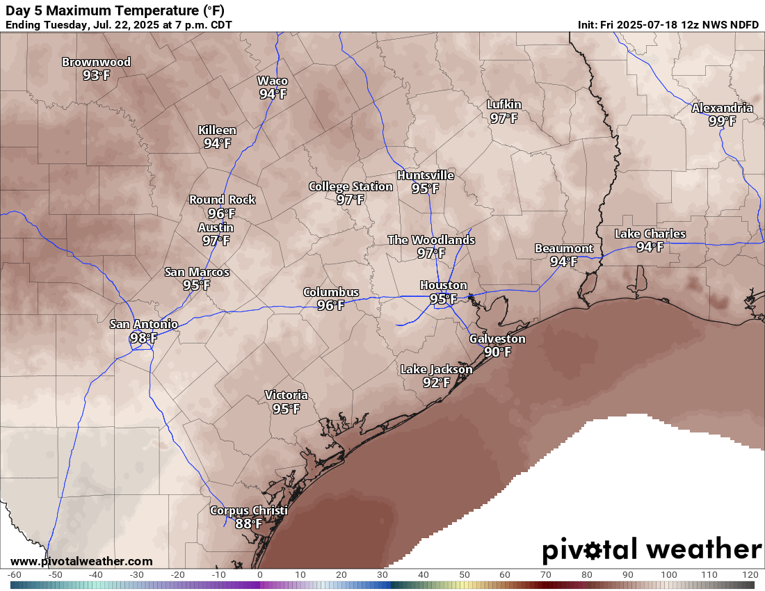
We’ve had very few days this summer that carried virtually zero rain chance. It would appear that Sunday through Tuesday carry good chances for that to be the case, however. Look for mostly sunshine. Another bout of Saharan dust could come our way Monday and Tuesday. For now, I’ll say mid-90s, but if the Saharan dust is minimal Monday and Tuesday, we do have a decent shot at upper-90s on those days in some parts of the area.
High temperatures on Tuesday will be near to slightly above normal. (Pivotal Weather)
Late next week
The heat should stay cooking for later next week, with highs in the mid to upper-90s continuing. We may even see a stronger surge of heat later next weekend or the week of the 28th. Rain chances may pick back up a little by Friday or next weekend. Overall, it looks fairly dry next week across the region.
In brief: Serious flooding is ongoing in Central Texas along the Guadalupe and San Saba Rivers after a foot of rain or more fell across parts of that area. Locally, another round of thunderstorms is likely this afternoon, followed by a fairly typical summer-like pattern this weekend and beyond.
Thursday & Thursday night storms
As noted yesterday morning by Eric, the forecast changed rather abruptly. And yesterday’s storms, while fairly quick movers, hit with some punch. Thankfully they did, as we saw instantaneous rain rates as high as 4 to 6 inches per hour in spots! Rainfall varied overall, with as much as 2 inches or a bit more in northeast Harris County and about a quarter-inch in western Harris County.
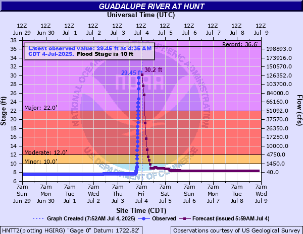
On a more serious note, parts of Hill County have seen some severe rain overnight. South-Central Kerr County is estimated to have received as much as nearly a foot of rainfall. This has led to flash flood emergencies there and along the Guadalupe River. The river at Hunt, TX is approaching 30 feet, beyond the 1987 flood event at that gage.
Historic flooding on the Guadalupe River in Kerr County. (NOAA NWS)
Downstream in Kerrville, they aren’t expected to hit the 37 feet of 1987, but it still looks to be a top 3 flood. Meanwhile, San Angelo saw around 8 inches of rain, with over 12 inches just north of the city. Additional rivers are expected to rise deep into flood stage, with major flooding possible in spots. If you have friends or family that headed out to the Guadalupe or San Saba Rivers, make sure they’re taking any warnings from local officials seriously. More rain is possible today, with some already occurring again this morning.
Today
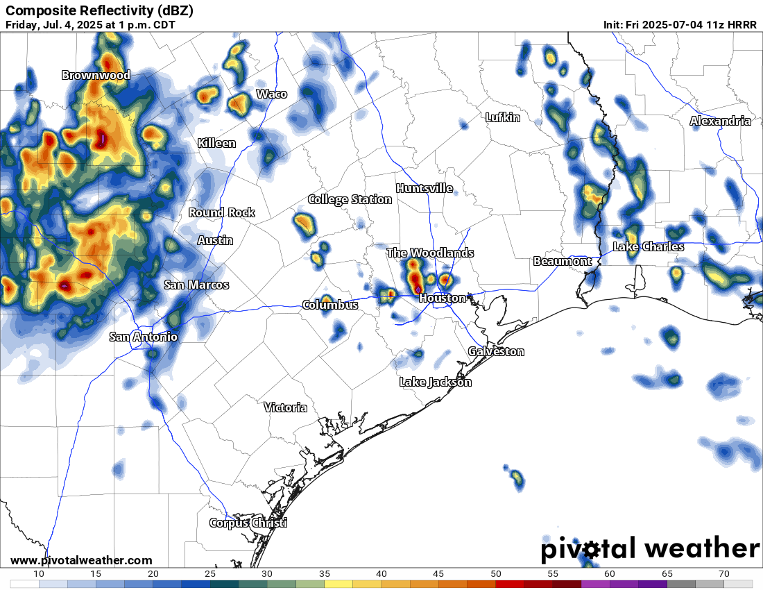
For Houston, today should probably unfold somewhat similar to yesterday with showers likely to pop up across the region this afternoon. Rain could again be heavy.
Forecast radar for 1 PM today shows isolated to scattered heavy downpours in the area. (Pivotal Weather)
Storms should keep moving today limiting flooding risk. Some gusty winds and frequent lightning will be possible as well. We do expect storms to settle down or dissipate in time for evening celebrations across the region.
Weekend
Additional scattered showers and storms are likely tomorrow, followed by a lesser chance on Sunday. Overall, if you can just manage to live with some passing showers for an hour or two, the weekend should be fine. We’ll keep watching in case anything should change on us again, however. Expect highs in the mid-90s and lows in the 70s.
Next week
It looks like a mostly typical summer week next week. I would expect isolated to scattered showers and thunderstorms each day, with highs in the 90s. There may be a skew toward slightly less afternoon storm coverage and hotter temps later in the week.
In brief: Another round of localized heavy rain, street flooding, and lightning will be possible this afternoon somewhere near or just northwest of Highway 59/I-69 in Houston. Slightly less coverage for Saturday, then more numerous showers and storms come at us Sunday and Monday before we dry out and heat up.
If you live inside the Beltway on the north and west side of Houston, you probably got walloped yesterday. Over 4 inches of rain was recorded at Ella and White Oak Bayou.
Rainfall estimates yesterday afternoon ranged from near or over 4 inches just west of the Galleria through Garden Oaks. (NOAA MRMS)
Rain totals north of 3 inches fell in a pretty broad area between The Villages and Garden Oaks. Many other locations saw 1 to 3 inches of rain. Outside the Beltway, it went quiet until you got up to about Kingwood (always, Kingwood) and down into Fort Bend County. Yesterday was just one of those days where boundary collisions ruled the day. A few storms popped up, steering winds were weak, and basically atmospheric bumper cars ensued until we exhausted the instability in the area.
Today
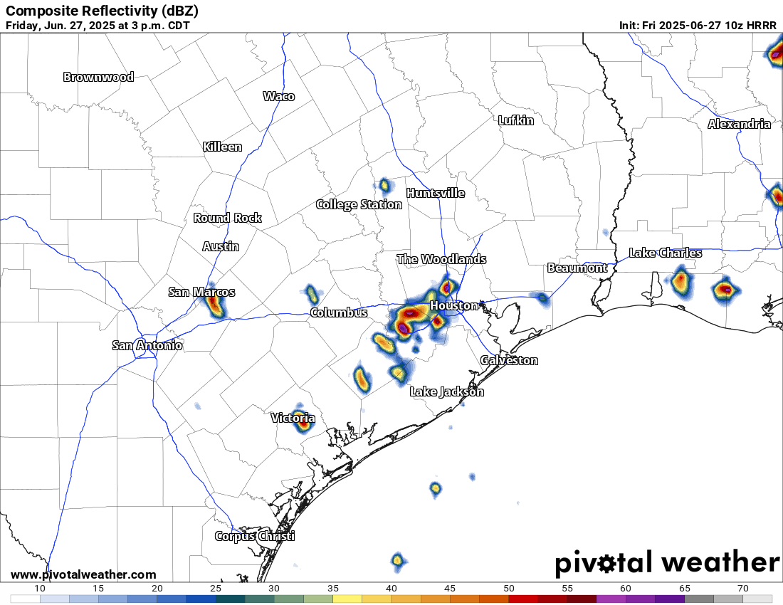
We don’t expect a carbon copy today, however I would not be shocked to see a generally similar setup play out across the area. We’re already seeing some downpours in Liberty and Chambers Counties this morning. As the morning goes on and the sea breeze starts entering the mix, migrating inland with peak instability, we’ll likely see storms fire up near Highway 59/I-69.
Forecast radar from HRRR model for 3PM today showing isolated heavy downpours. Don’t focus on the specific location but rather the generalized picture. (Pivotal Weather)
A few places could again see multi-inch per hour rain rates that could cause street flooding. We’re holding off on a Stage 1 flood alert today, but I will admit it’s a close call. Just use caution in any storms today, as you should in summer.
Weekend
I think things will ease up a bit on Saturday. There will be showers and isolated thunderstorms around. There may be locally heavy downpours for a short time in any given spot. But overall the intensity and coverage of storms may be lower tomorrow than it has been to close the week out.
Unfortunately, the same does not hold true for Sunday, which should see more numerous, if not widespread showers and thunderstorms across the region. Storms could begin firing up as early as mid-morning and continue through the day, migrating generally north and west as the day progresses. Have an umbrella handy both days, but have a good indoor backup plan available on Sunday.
Temperatures should top out in the lower to mid-90s on Saturday and low-90s or even upper-80s on Sunday.
Monday
Monday looks like another active day with showers and storms popping with daytime heating. Look for low-90s and scattered PM storms.
Rest of next week
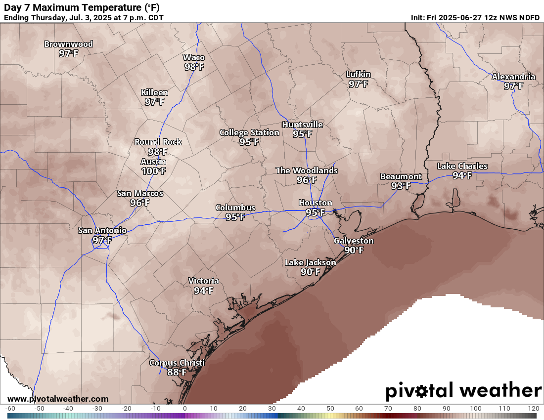
Tuesday begins a trend of diminishing rain chances. Expect more of isolated coverage of storms on Tuesday, a handful on Wednesday, and perhaps none at all by the end of the week. In response, temperatures are going to begin to pick up. We’ll have mid-90s Tuesday and Wednesday, followed by a chance at upper-90s to close the week.
By next Thursday, some areas do have a chance at upper 90s. (Pivotal Weather)
Recent rains and saturated soils may act to keep daytime highs from getting much past 97 or 98 degrees or so officially, but there may be a few parts of the area that threaten upper 90s to near 100 by next weekend. Stay tuned.
Tropics
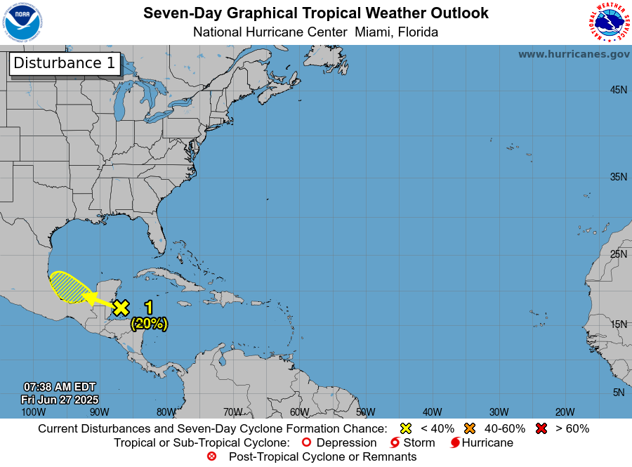
A discerning eye will notice a new tropical area to watch on the National Hurricane Center site down in the Bay of Campeche. This has a very, very slight opportunity to develop over the next couple days.
A possible disturbance in the Bay of Campeche will not be of concern for Texas. (NOAA NHC)
The good news is that it will almost certainly scoot right into Mexico by Monday. This limits any significant development risk, and this is not a concern for the Texas coast. The next tropical area of interest may be something in the northeastern Gulf or off the Florida coast by next weekend. That too is expected to stay away from Texas and is mainly worth watching for Florida or the Southeast coast.
In brief: Mostly minimal shower and storm coverage this weekend in Houston will increase by a good bit next week. Additionally, we take a look at why this hurricane season has started quieter than most recent ones.
Hurricane season so far
The forecast is pretty straightforward today, and we’ll get into that below. First, today is June 20th, and to this point I don’t think we’ve said a word at Space City Weather about hurricanes or tropical storms. It’s a refreshing change of pace after recent seasons. In fact, the last year that we did not have a storm in the Atlantic before July 1st was back in 2014. It’s been a while.
All’s quiet for now. (NOAA NHC)
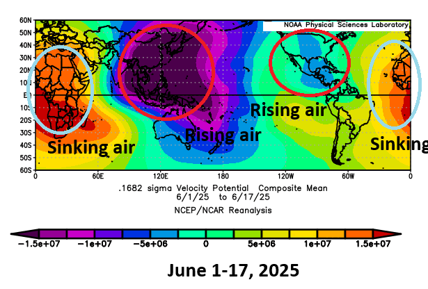
Meanwhile, the Pacific has been churning out storms apace this season, with five so far. Of course, only one of them (Erick, which just made landfall yesterday) was a big storm. Still, the conditions to this point this hurricane season have strongly favored the Pacific. You can thank dust and wind shear in the Atlantic for one, but those things aren’t abnormal, even in recent Junes. So there has to be more at play here.
Rising air has been centered on southeast Asia and Central America so far this month, with most of the Atlantic in a generally unfavorable background state. (NOAA)
We often talk about the “background state” of the atmosphere. You have individual tropical waves and systems and such through the year, but the background state is important. Are the overarching global weather conditions favorable for development or unfavorable? So far this June, we’ve had the majority of rising air, or a “favorable” background state for tropical development sitting over Central America. Rising air is what helps thunderstorms to develop. Since tropical weather generally moves east to west across the planet, this has meant that most seedlings for development are being planted in the eastern Pacific Ocean. Sinking air sits over Africa and extends all the way across to the Caribbean islands. Sinking air tends to suppress cloud development and dry the air out a bit. By the time any waves can really get going, they more than likely end up over land or kicked into the Pacific.
Over the next couple weeks, this pattern is unlikely to change a whole heck of a lot, but we may start to see slightly more favorable conditions emerge over Africa or the far eastern Atlantic by early July. That said, there are no guarantees that actually means anything. Realistically, the next 7 to 10 days look calm and the 10-to-14-day period has no signs of meaningful change yet.
We do still expect an average to above average hurricane season; June’s activity has no real correlation to the rest of the season, so you can’t decipher any relationships. But when you can get a hassle-free month in hurricane season, you take it without complaints.
Bottom line: You still have time to prepare for hurricane season.
Today
We had a slightly higher coverage of showers yesterday than we did Wednesday, and today should be fairly similar. Most of us will stay dry, but some areas could see up to an inch of rain or so in a cooling downpour. We hit 95 yesterday officially, and we should make a run for that again today.
Weekend
The coverage of showers may actually decrease some this weekend. Both Saturday and Sunday carry something like a 15 to 20 percent chance of a shower. Doesn’t mean it won’t rain, but it does mean the odds aren’t high! Sunday probably carries a slight edge over Saturday in terms of higher shower coverage. Temperatures will be steady with low to mid 90s for highs and mid to upper 70s for lows away from the coast, with low 80s at the coast.
Next week
While this week was pretty quiet after Monday, next week should be a bit busier each day. We’ll probably carry 30 to 40 percent or even higher rain chances each afternoon, with pop up thunderstorms.
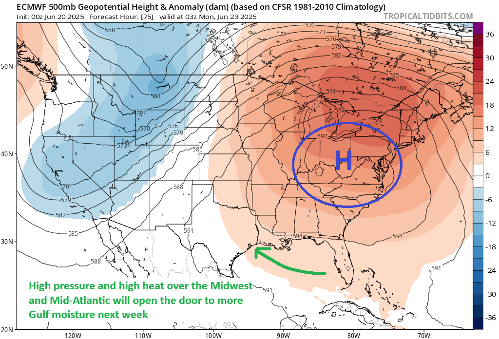
High pressure that will bring record heat to the Midwest, Mid-Atlantic, and Northeast next week will also anchor in a spot that opens the Gulf a little more for us to receive daily showers and storms. (Tropical Tidbits)
The culprit will actually be the high pressure system responsible for record heat that I’m sure you’ll hear about in the news across the Eastern U.S. As that anchors over the Appalachians, it will actually open the door to added Gulf moisture in Texas. Precipitable water (or how much moisture is available in the atmosphere) increases about 25 percent or more next week compared to today. That should help boost thunderstorm coverage each day.
The increased coverage of storms probably means we see more low-90s for highs and 70s for lows areawide next week.