In brief: A complicated winter storm for Houston next week continues to give us fits in weather modeling, with today’s flavor being the potential for more snow and sleet than anything else. However, we expect the forecast to continue changing over the weekend and will keep you posted. Either way, travel across the Houston area may become very difficult Tuesday and Wednesday.
Winter storm update
What has changed since yesterday? Well, a lot. The storm is back. But this time it’s a bit colder overall, which means perhaps more in the way of snow and sleet than ice. That would be good news. That said, there remains a ton of uncertainty. As a native of New Jersey and having cut my teeth forecasting in Upstate New York, I have learned to never take a winter weather forecast from models literally. This is doubly true in the South where snow and ice are generally outside the bounds of climatology, which tends to give models fits and leads to us having to caveat every single thing we say.
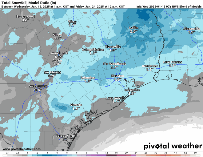
Anyway, here’s the NWS National Blend of Models snow forecast for the last several runs. This incorporates a bunch of models and weights them. You can see a lot of fluctuation in outcomes here.
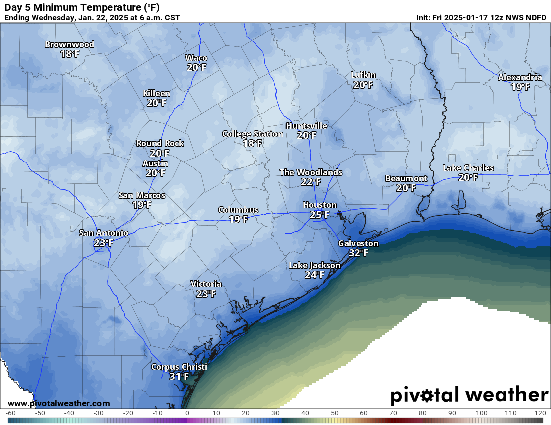
What are we confident in? The timing. Precipitation should begin, lightly on Monday afternoon or evening. The height of the storm would likely be from about 4 AM to Noon Tuesday, with conditions slowly improving Tuesday afternoon. We are also fairly confident that Wednesday morning should be the coldest morning next week. A tropical-plant damaging freeze is likely on at least one or two mornings. An irrigation system damaging freeze is also likely if precautions are not taken.
What are we not confident in? How much of what falls where. While the models have brought the storm back into the forecast since yesterday, they remain a bit split on exactly how it plays out. We can say that in general today, it appears the highest odds of snow are north and east of Houston and the highest odds of ice are south of Houston and near the coast. Beyond that? We can’t say much. Unfortunately, that’s the most important question to answer in terms of travel conditions, school closures, etc. We will get some confidence on this through the weekend. We would think that by the morning of the MLK holiday, decisionmakers will have enough to work with.
What else aren’t we confident in? How cold it gets Wednesday morning. Snow cover is a significant component of what we refer to in meteorology as “ideal radiational cooling,” the premise being clear skies, light winds, and snow cover all contribute toward an ideal scenario for cold weather. Without snow cover next week, we’ll likely see mostly 20s for lows with a few teens north. Cold for sure, but nothing extreme. However, let’s say we get 2″ of snow across Houston. Then we could easily shave an additional 5 degrees off that, nudging us into the teens everywhere except the coast.
So there is a lot to unpack here still, and over the next couple days we should begin to see clarity. Eric and I will keep you posted on all that as it evolves with regular updates through the weekend.
Houston Marathon
I admire anyone that runs a marathon. I especially admire anyone that does so with temperatures in the 30s and a north wind gusting up to 25 mph or so. That’s what we have for you on Sunday. Temps will rise a little through the run, possibly getting to near 40 degrees by the end, but either way, it’s going to be very cold. Good luck to Eric and to all those participating in the run(s) this year!
Rest of the forecast
For those of you with weekend plans, there could be an isolated shower this afternoon or tomorrow afternoon as the front moves in, but otherwise it looks dry. Temperatures will peak in the upper-60s or low-70s today, so bust out the shorts and enjoy! Tomorrow will likely get into the 60s before the front hits in the afternoon. Temperatures will then fall tomorrow evening through the 50s and 40s and into the 30s in most of the area, with some 20s in more rural spots north of I-10 by Sunday morning. Sunday gets up to the low or mid-40s, maybe and looks windy and cold.
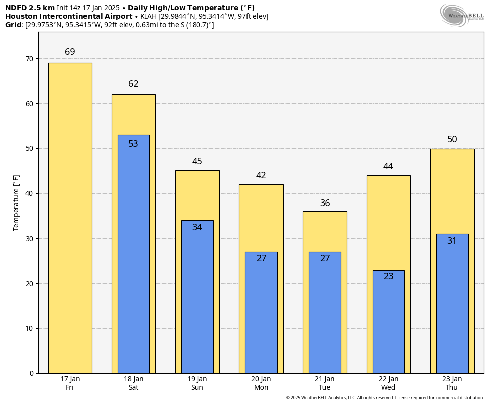
Monday will start in the 20s and warm into the upper-30s to low-40s. Depending on how the storm evolves, look for lows in the upper-20s and highs in the low or mid-30s on Tuesday with a breeze as well. Wednesday will probably get up near 40, but as noted above, there is some uncertainty on how cold it gets in the morning. And then a more proper warm up ensues for later next week.
Again, we will keep you posted regularly through the weekend on next week’s cold and potential winter precipitation.