In brief: A few showers are possible today, but for the most part Saturday should be an okay day. Another round of storms and potential heavy rain arrives tonight and Sunday which could renew street flooding in spots. Quieter, hotter weather arrives next week.
For the latest flood gauge information, visit the National Weather Service or Harris County Flood Control websites.
Also, don’t forget that we have an app for Android and Apple that you can download to browse the site, access some features, and be notified of posts.
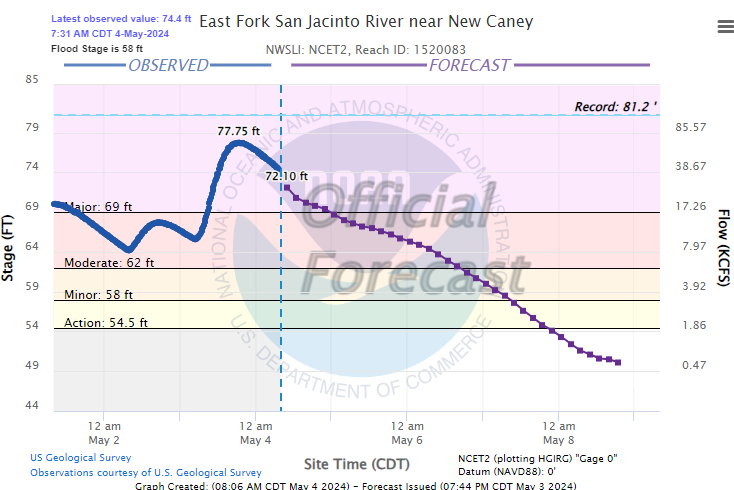
The East Fork of the San Jacinto has crested at New Caney but will only slowly fall.
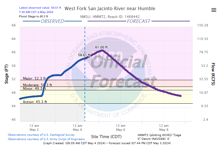
To the south, the West Fork of the San Jacinto at Humble is expected to crest on Sunday and remain in major flood until at least Monday or Tuesday.
The San Jacinto will continue in major flood downstream as well, with very fast flow passing barges near I-10 which could lead to some loss of mooring.
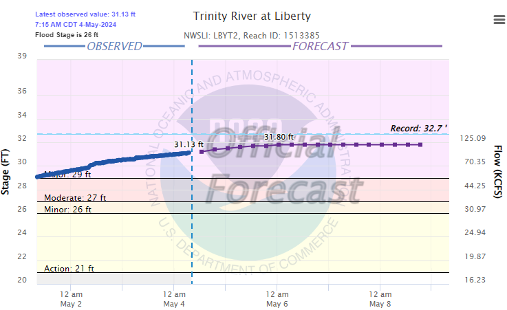
Unfortunately, the Trinity in Liberty County is going to remain just shy of record levels for several days, allowing major flooding to continue.
Please continue to heed the advice of local officials and never drive around barricades.
Saturday morning & afternoon
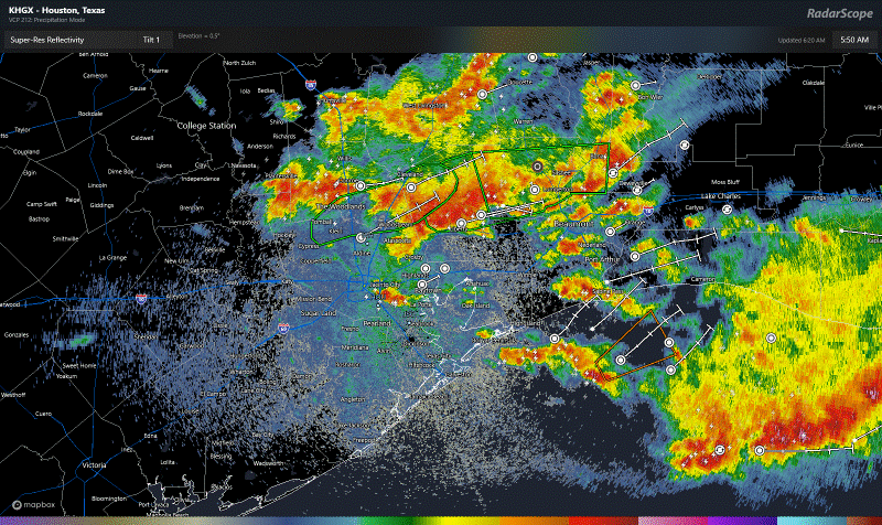
The good news this morning is that radar is vacant around Houston for the first time in some time. There are a few storms passing through the Beaumont-Port Arthur area up toward Jasper, but they’re moving offshore or into Louisiana. I would expect the morning to be fine in most areas.
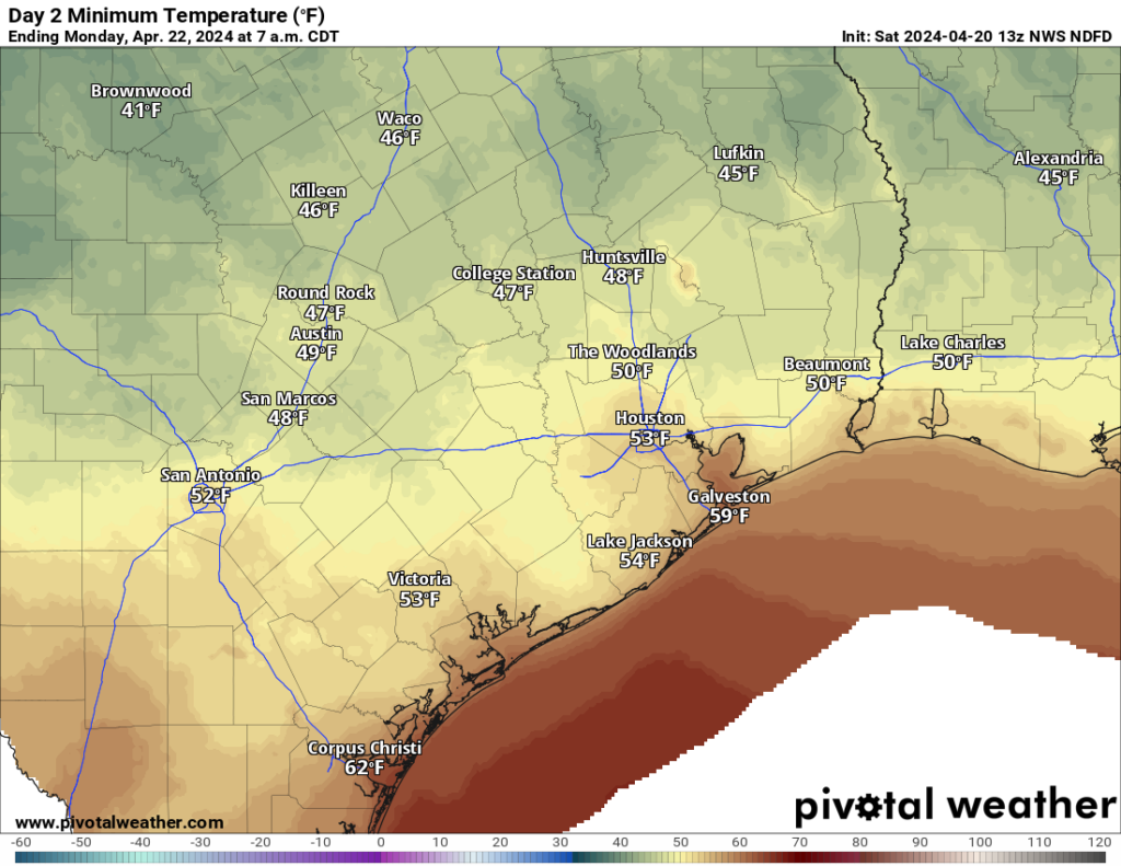
With daytime heating, scattered showers and a few thunderstorms should begin to develop this afternoon. These will be hit and miss; some people will see downpours, others will be dry. I expect these will move along at a decent pace. The belief is that both the movement and the actual rain rates with these will be a bit lower than we’ve seen in recent days. The best chance for this will be north of I-10 after 12 to 2 PM, which isn’t great news for areas dealing with river flooding, but hopefully they don’t add much to problems. We should make the low to mid-80s today.
Tonight & Sunday morning
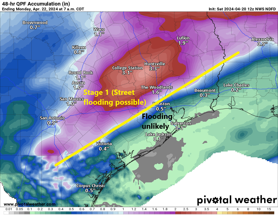
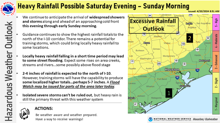
Here’s why Flood Watches remain in effect. Storms this afternoon in Central and West Texas will slide east with a disturbance and likely congeal into a well organized area of rain and thunderstorms. This should arrive in our area tonight, after 12 to 2 AM or so. There are still questions regarding how this plays out. Some model guidance shows less organization to the storms and more scattered type activity. Other data suggests it will push through at a good clip. And yet other data has sort of a repetitive scenario, where we see multiple rounds of storms, much like occurred on Friday and Thursday.
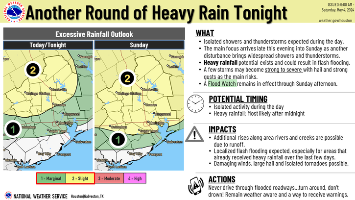
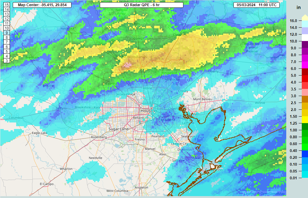
For now, a widespread half-inch seems reasonable for Houston and points south, with 1 to 2 inches north of Houston. There will almost certainly be higher amounts, with the most likely areas being north of Houston. In those spots, 2 to 5 inches of rain could fall on top of already saturated ground, leading to rapid street flooding. This would be mostly a concern in the northern part of Harris, Montgomery, and Liberty Counties and points north. If you have outdoor Sunday plans, it would be best to have an indoor backup plan available.
In addition to rain, some storms could be strong with a couple perhaps producing some modest hail or strong winds.
Monday & next week
We expect the pattern to begin to transition beginning Monday into the forecast heat for next week. While a few showers or storms are possible, significant weather is not expected on Monday. The main story will be heat next week, building through the week.
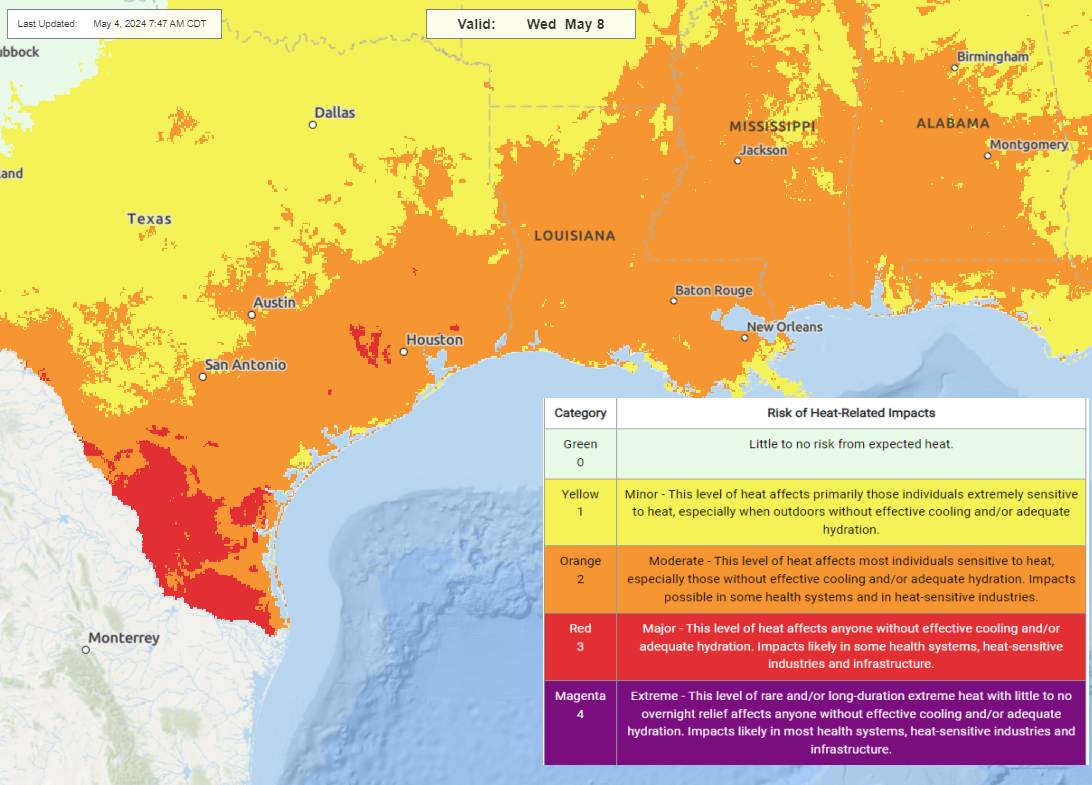
Heat will build up to “major” levels, as classified by the National Weather Service, with low to mid-90s likely for highs by Wednesday and/or Thursday. Given that this will be our first real heat of the season, give your body some extra time to adjust. We’re not used to it just yet. We’ll have more tomorrow, or later today if necessary on the rain.