No one complained to us that we skipped last week’s tropics post. Hopefully no one complains that this week’s is rather short!
Tropical outlook in a sentence
There are no signs of any organized systems in the Atlantic Basin over the next week to ten days, but we do expect our slumber to gradually end come August.
2022 as of today: Does the quiet start mean anything?
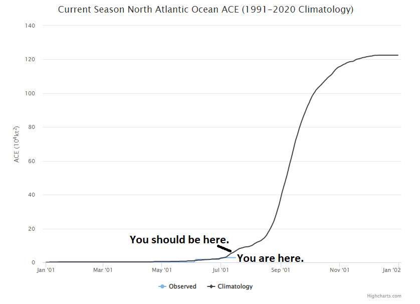
Much like last July, this July has been quite quiet. We managed to get Colin briefly back on July 2-3, and since then there’s been nothing. Last year we had made it to E by now. In 2020, we were on F. We remain at 2.8 accumulated cyclone energy units to date. The normal is just over 6 by this point. For the season, we typically see above 120, so we have a long, long road ahead.
While accumulated cyclone energy (ACE) is below average now, average is pretty low. We have another 2 to 3 weeks before the big ramp into peak season. (Colorado State University)
Just to refresh: ACE is an equation that tallies how long a storm maintains an intensity. It’s then accumulated, storm by storm, over the course of the season. Most recent seasons have been active to very active. While it’s nice that 2022 is beginning below average, it’s also not exactly meaningful. From an ACE point of view, 95 percent of the season is yet to come. The big ramp in activity typically begins around August 15th, so we’re 2 to 3 weeks away from normally having a bit more to discuss.
What’s happening now?
When I say not much is happening in the tropics, I really do mean that. It’s very, very quiet. We’ll occasionally get a robust wave off Africa, but it typically either runs into significant dry air and dust or wind shear and dissipates.
Saharan dust has impacted Houston lately, and there’s an awful lot of it (yellow, orange, red, pink) in the Atlantic Ocean. So dust season isn’t over yet. (University of Wisconsin SSEC)
While we’ve had some Saharan dust over Houston lately, we may see more next week. There’s a lot of dust out there, so we just need a brief window to open to sneak some more of that into the Gulf.
In addition, wind shear in the Caribbean is strong and projected to stay that way over the next week or so. Anything trying to get here will struggle. And our recent spate of hot weather is basically being caused by high pressure sealing Texas off from any Gulf mischief. The longer that continues, the worse the drought but the less risk of hurricanes. Mostly.
We see no real meaningful sign of change for the time being, so let’s continue to enjoy the calm, and use this time to ensure we’re prepared in case things do change later in August or September.
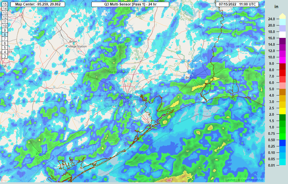
A number of folks across the area saw rain yesterday, which was great.
A good chunk of the area saw rain yesterday, with just a couple spots seeing close to 2 inches. (NOAA NSSL)
We need what we can get right now, coming off our hottest 5 consecutive days on record Saturday-Wednesday. I’ve seen folks say that 1980 and 2011 were worse. By July 14th of those years, we had amassed 20 100° days in 1980 and 11 in 2011. So far in 2022, we’ve managed 13 of them. So yes, 1980 was hotter — during the day. At night is where things have changed. 1980 averaged 75.6 degrees for July nighttime lows. So far this month, we’re averaging 78.1 degrees for nighttime lows. As such, this July is on pace to be our hottest. Warmer nighttime lows are a health hazard, extending the heat.
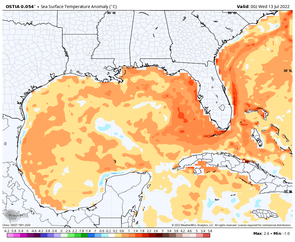
A warmer than normal Gulf of Mexico is likely contributing to our warming nighttimes.
Between 2010 and this year, Houston has set or tied almost 150 daily records for warm nighttime lows, sometimes multiple times over the period. Galveston has set or tied 189 of them. A frequently warmer than normal Gulf (including this year as shown above), climate change, and land-use change (urban sprawl) are all contributing factors to making heat waves somewhat worse than they were in the past. So this isn’t the periodic hot summer. It’s the slightly more frequent hot summer with an extra spoonful of sprinkles on top. We see no real end in sight to our current hot weather.
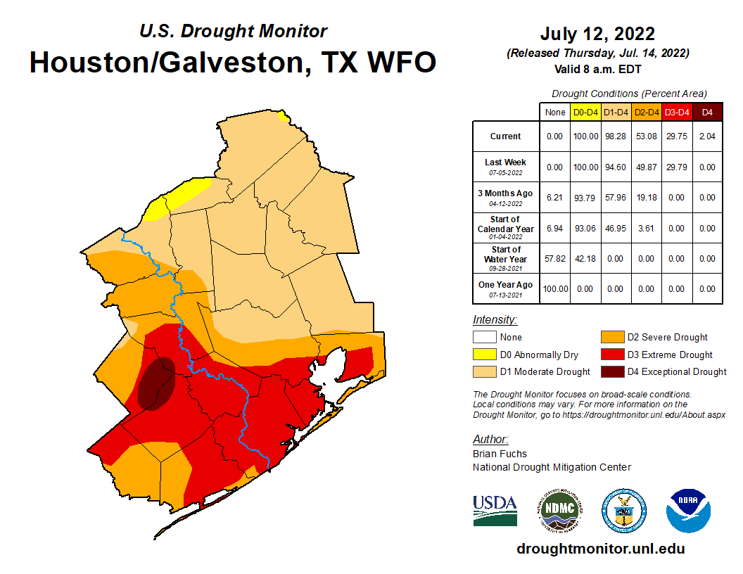
Drought has worsened as well.
Drought is now classified as “exceptional” for a portion of Wharton, Colorado, and Austin Counties. (Drought Monitor)
The entire Houston area is officially in drought. The southern half of the area remains in extreme drought, the second worst category, and this week saw the addition of some exceptional drought, the worst category, west of Houston. Notably in 2011 the entire area was in exceptional drought at this point. With August still ahead of us, I am not especially thrilled with where we presently stand.
Friday
After yesterday saw some rain, today should see some more. We are starting with just a couple showers here and there, mainly south of I-10. Today’s focus should be south of Houston. That isn’t to say that if you live north of I-10 you won’t see anything, but the odds are highest to the south, the part of our area most in need right now. Look for coverage of storms, especially south of the city to become more numerous as the afternoon develops. Locally heavy rain is possible today, perhaps up to 2 or 3 inches in the most persistent storms, so do keep an eye out for localized, brief street flooding in those areas hit hardest.
With rain showers and some clouds, look for temperatures ranging from the upper-80s to mid-90s today.
Weekend
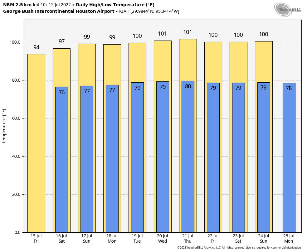
Look for rain chances to fall back a good bit to a requisite 10 to maybe 20 percent chance on Saturday and Sunday. High temperatures, while hot, should stay sub-100 for most of us. I would expect lows in the 70s to near 80 and highs in the upper-90s both days.
Next week
We could see a slight uptick in shower chances on Monday, but I wouldn’t get my hopes up. Otherwise, high pressure will begin to re-flex itself overhead. This means heat, humidity, and just minor rain chances on any given day. Look for 100s to populate the forecast again, along with frequent heat advisories.
I was taught that if you’ve got nothing good to say, don’t say anything at all. (Weather Bell)
Overnight lows will bounce between the upper-70s and low-80s. In other words, more of the same. There’s no meaningful sign of change to this pattern at this time.
Tropics
If you want good news, the tropics are quiet right now, and they look to stay that way for awhile. We’ll update things again next Tuesday. It’s tempting to wish for a tropical storm or hurricane to break our misery, but this feels very much like a case of be careful what you wish for. Here’s hoping however things go over the next few months, they go gently.
Since our post last week, Tropical Storms Bonnie and Colin have formed and exited the Atlantic basin. Looking ahead, those should be the last storms for a bit.
Tropical outlook in a sentence
Over the next week (or longer), we are not expecting any new systems of note in the tropical Atlantic.
Bonnie & Colin
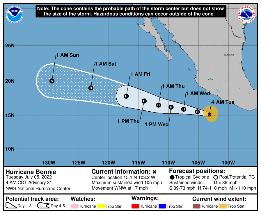
This time last week, we noted that PTC #2 would likely become Bonnie and “has a chance to become a hurricane as it approaches Central America, but it probably has equal chances of not being one too.” As it turns out, the latter was correct. Bonnie’s forward speed and a bit of shear was just too much to overcome, and the cyclone never organized until it moved into the Pacific. Since it held itself together across Central America, it retained the name Bonnie, and is heading out to sea.
Bonnie finally did become a hurricane, and it’s marching out to sea in the Pacific Ocean. (NOAA)
Meanwhile, Colin formed briefly off the Carolina coast, somewhat of a surprise from last Tuesday’s post. Colin didn’t last long, about 24 hours from Saturday through Sunday, and it dumped a few inches of rain in parts of the Carolinas.
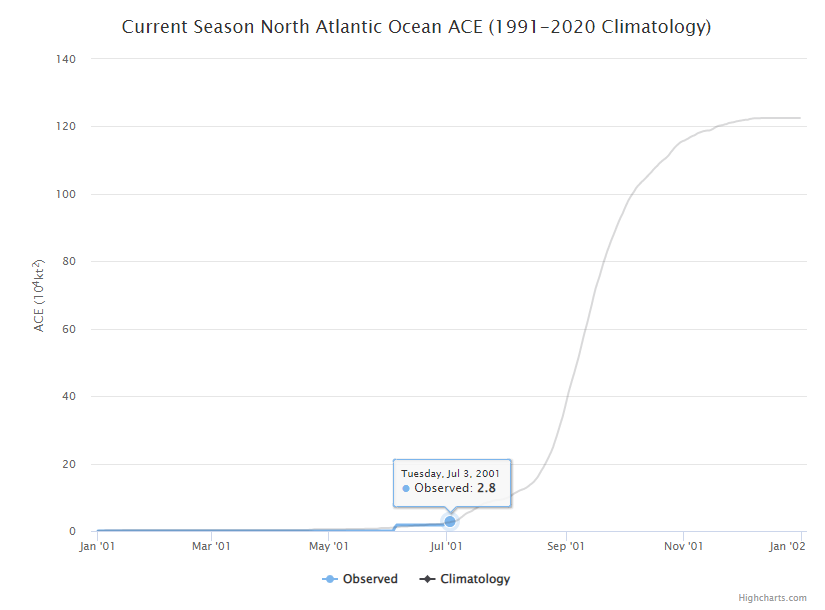
The accumulated cyclone energy of the 2022 Atlantic hurricane season is right at normal for the moment, while our 3 named storms is more typical of early August. (Colorado State University)
ACE tallies up how long a storm maintains a certain intensity during its lifetime. The bigger the storm, the bigger the ACE, and obviously the more of those storms in a season, the higher the value will be. Typically, our 3rd storm does not form until early August, so from that point of view, we’re cranking. But they’ve all been fairly weak systems, so overall our season is off to a mostly normal start, which is nice for a change.
That said, note from the chart above that we still have roughly 97.7 percent of the season ahead of us from an ACE standpoint. Again, it’s normal for the early season to be generally weak.
Looking ahead
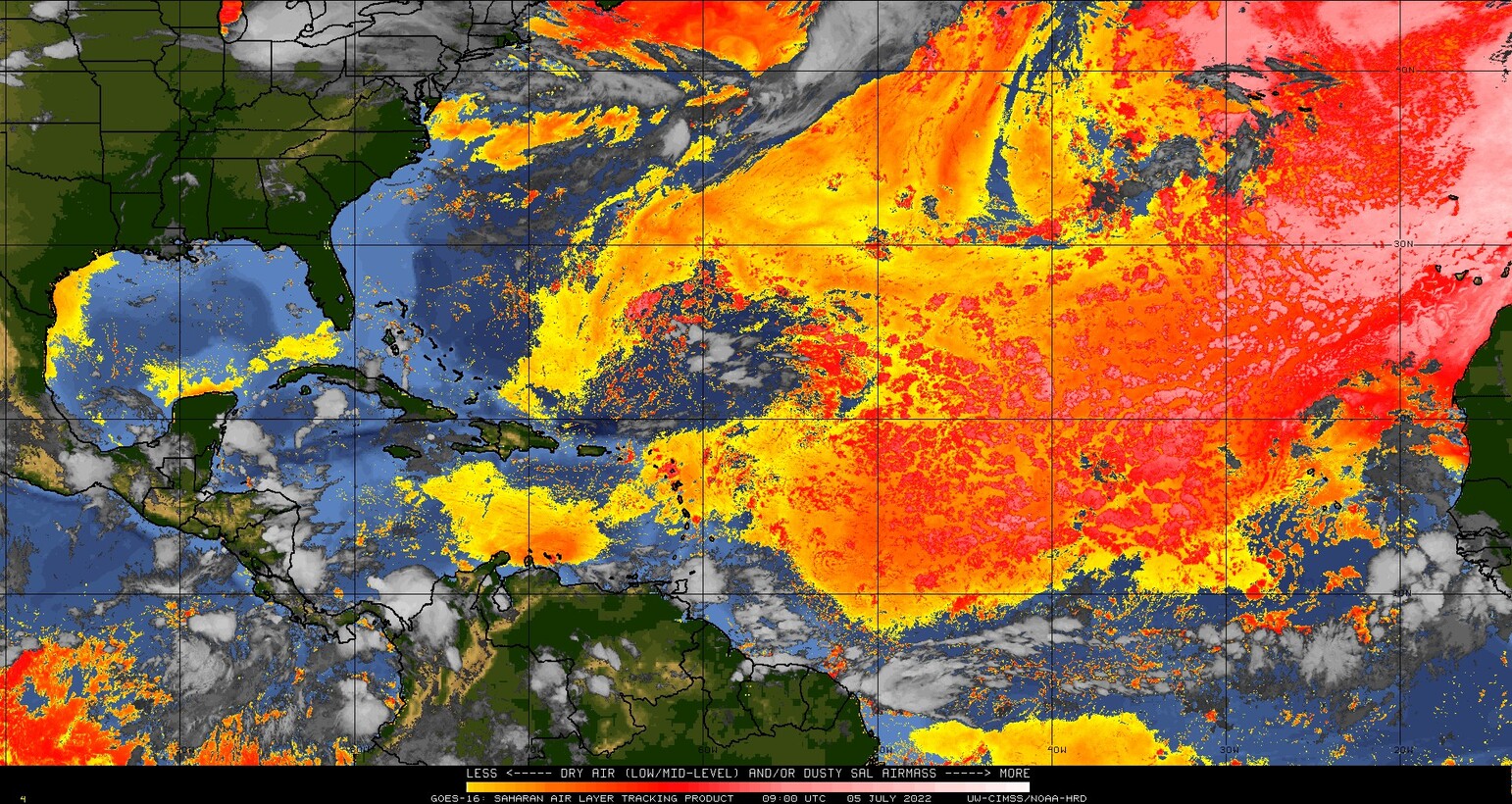
Over the next 7 to 10 days, we are not expecting any tropical development in the Atlantic. As always, you could get a Colin scenario, where something brief and weak can spin up close to home. Short of that, however, it appears dust and minimal tropical waves of note will be the story over the next week and probably a bit longer. Dust tends to indicate dry air is present, which is not something tropical storms care for. This is also the time of year we expect widespread dust over the Atlantic basin.
Yellow, orange, and red colors indicate Saharan dust over a broad chunk of the Atlantic Ocean, something not terribly uncommon for this portion of the season. (University of Wisconsin SSEC)
Some of the typical things we’d look for to kickstart tropical activity are sitting out there on the horizon per the models, so I would expect maybe the last week to 10 days of July to provide some items to watch, but that’s purely speculative right now. For now, enjoy the quiet we have and use it as an opportunity to ensure you’re set for the August and September gauntlet.
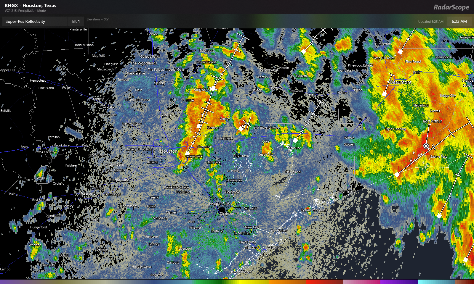
Good morning. It’s pretty evident that the heaviest rain will fall to our east today. That said, there are still storms and heavy ones at that in the area. A storm east of downtown dumped nearly 3 inches of rain in an hour as of 6:20 AM, where Brays Bayou crosses Lawndale Street on the East side. That amount of rain that fast can cause street flooding, so do keep this in mind this morning as these downpours lift north and east across the area. You may encounter street flooding, so please use caution and don’t drive through flooded roadways.
Radar as of 6:25 AM shows heavy downpours on the eastern side of the city, with the most heavy rain closer to Beaumont and Port Arthur. (RadarScope)
So with all that being said, obviously, this will probably end up a very disappointing system for our region as a whole, especially if you live on the west side. Coastal areas did well yesterday, and today’s rain will certainly be welcome. But still. While we aren’t heading back into the pattern we had in June, at least not as extreme, it will turn hotter and drier again. We’ll have some daily rain chances to cling to each day, but that’s a proverbial drop in the bucket in terms of what is needed to eradicate drought.
Speaking of, the drought monitor update from yesterday, which includes rain through Tuesday showed that drought had expanded to cover virtually the entire Houston region now, a very large increase in such a short time.
Drought coverage expanded to officially include almost the entire region, with the significant drought continuing south of I-10. Rains since this past Tuesday will help a bit but may not cut back coverage much. (US Drought Monitor)
Depending on how the next few weeks evolve, this could start to become a very bad drought for our region, or just sort of hang in place “as is” for awhile. I’m personally not particularly optimistic given both nearer-term guidance and longer-range guidance, which continues to suggest below average rainfall. With the holiday weekend celebrations ahead, please be mindful of burn bans (which cover almost the entire state), and please be extra cautious with fireworks this year. I have not heard of any local fireworks bans beyond already existing regulations, but that doesn’t mean dry ground can’t ignite in some accidental situations. So the best advice is to use more caution than usual this year.
Rest of today
This morning’s rain and localized downpours will continue off and on through the morning, likely shifting east and weakening this afternoon. Most areas east of I-45 will see some rain, but amounts will widely vary from another 1 to 3 inches in spots to just a few tenths in others. West of I-45, you will see isolated showers or storms, with many spots seeing nothing. The exception will be south of Houston. Areas across much of Brazoria and Galveston Counties will continue to see scattered storms into early afternoon.
Readers checking us out from Beaumont & Port Arthur will note some very heavy rain, especially in Port Arthur this morning. I would presume street flooding is likely to begin there soon on a wider scale basis. Use caution in that area this morning.
We only managed 82° officially yesterday at Bush Airport, about 6 degrees warmer than the record coolest high temp for the date. Clouds today should hold us back again. Look for low to perhaps mid 80s.
Weekend
With the tropical low lifting away, we’ll gradually slip back into a more normal summer pattern. Look for a chance of scattered showers or storms tomorrow, but coverage likely won’t exceed 30 or 40 percent and again focused to the east of downtown Houston. Sunday sees even lower rain chances, probably below 20 percent. Look for highs to recover into the low or middle 90s, with lows back into the upper 70s.
Next week
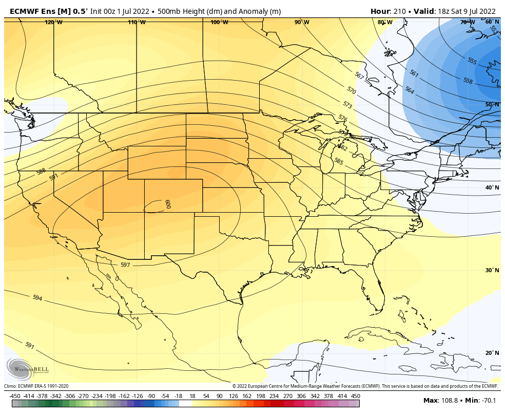
The weather pattern next week is likely to be dominated initially by a moderately strong ridge of high pressure over Texas. This should keep us mainly dry through Tuesday with mid to upper 90s. On Wednesday and Thursday, we’re likely to see the high pressure relocate into the Rockies. Normally, this would open up the Gulf more and allow for higher rain chances. In this case, the high also expands significantly.
A 600 decameter ridge over Colorado next weekend means we’ll likely stay hot and mostly dry after a brief uptick in rain chances mid to late week. (Weather Bell)
This will give us maybe a day or two of increased rain chances Wednesday and Thursday, but probably no better than 30 percent or so. Otherwise, look for mid to upper-90s to persist, and perhaps drier weather into the weekend. Seeing a 600 decameter ridge on the map above is really impressive for a 50 member ensemble mean. This means that the model is highly confident in a very strong heat pattern for the interior West, likely expanding to include most of Texas heading toward the week of the 11th. It won’t be as hot relative to normal as June saw, but it will still be very, very hot.
June recap
We’ll close with this: June 2022 was the hottest in Houston’s recorded history. Our average temperature in June was 86.7°, which broke 2011’s record by a half degree (86.2°).
It was also the hottest June on record in Galveston by over a full degree. June 2022 saw 87.5° for an average temperature, compared to 86.2° in June 2011. 87.5° for a month is hotter than any July on record as well. In fact, June 2022 will end up being the 4th hottest month of any month on record in Galveston. Of the 60 possible high and warm low temperature records Galveston could have set in June, they set or tied 19 of them, over 30 percent. Galveston’s records extend back to 1874.
A number of factors all play into these records: An extremely warm Gulf of Mexico, the drought, a stagnant weather pattern, urbanization, and, yes, climate change. Hopefully July is better behaved.