In brief: Beryl’s approach to Texas will lead to a messy Sunday night and Monday morning across the Houston region. The storm’s core of strongest winds will pass directly through the city, but we’ve been fortunate to not see rapid intensification (so far) today. This post highlights the latest forecast and threats to the metro area.
Beryl status as of 10 pm CT
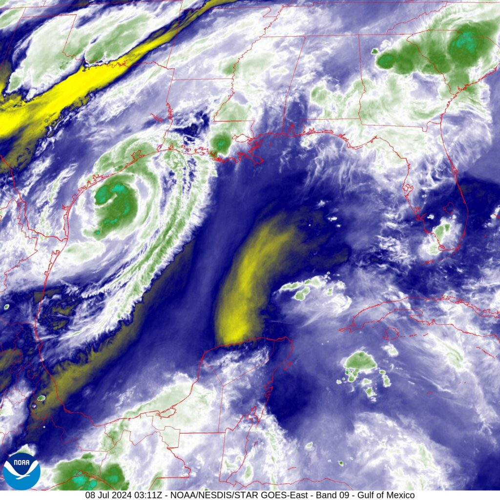
As it nears the Texas coast tonight, Tropical Storm Beryl’s maximum sustained winds are 70 mph, which is just below Category 1 hurricane status (winds greater than 74 mph). The storm is moving to the north-northwest at 10 mph, and is only about 70 miles away from the coast. Its central pressure, 986 mb, is slowly dropping indicating ongoing organization.
Beryl’s intensity and track
During our post this afternoon I extolled the virtues of dry air, and the fact that it was helping to slow the intensification of Beryl. Happily, that trend has continued throughout the evening hours. There is still some time for Beryl to rapidly intensify as we have seen with past hurricanes nearing the Texas shore, but time is running out with a landfall expected six to eight hours from now, between 2 am and 4 am CT on Monday. It is likely that Beryl comes ashore as a Category 1 hurricane, and the window is closing on something stronger than this. All that said, tropical systems are unpredictable, so let’s keep cheering on dry air until landfall early tomorrow.
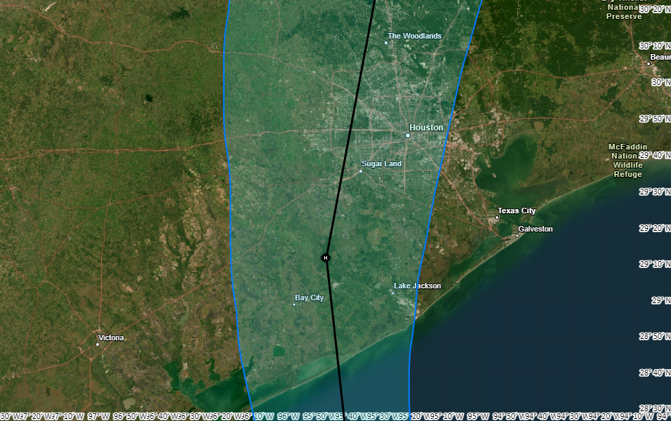
Beryl’s track toward the coast has remained similar for a day now, with a landfall expected near or just east of Matagorda tonight. The center, traveling more or less due north, will pass near locations such as Katy and The Woodlands on Monday morning before exiting to the north.
How much will Beryl blow?
The magnitude of Beryl’s winds, and subsequent power outages, will be determined by the extent to which Beryl strengthens before landfall. It is clear that virtually no part of the Houston metro area, save for the slim possibility of Lake Jackson, is likely to experience hurricane-force sustained winds. However, much of our region is likely to see tropical storm force sustained winds during a period from the wee hours of Monday morning, starting perhaps between 2 to 4 am, through the late morning hours. Our region will see higher gusts during that period.
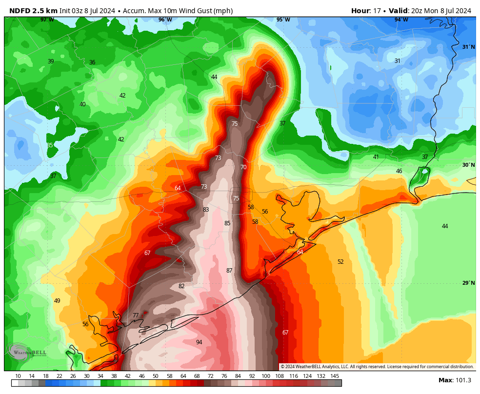
I went a bit deep on the possibility of power outages in our post earlier today, and my thinking more or less stands. The less that Beryl intensifies before landfall, the better. My hope is that outages will be manageable and restored within a few days. But that is not something I am comfortable guaranteeing.
Rainfall expectations
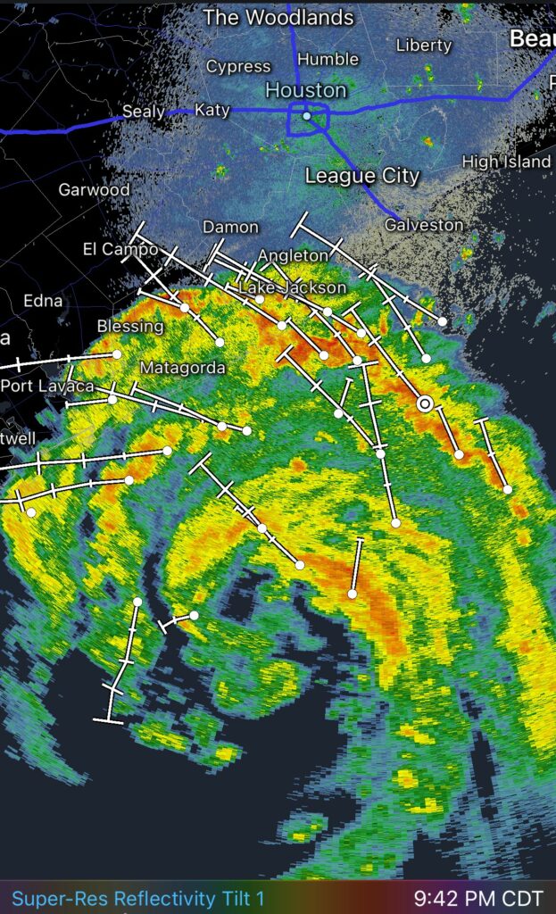
I have found myself looking at the radar this evening in equal parts awe and dread. Beryl’s center is clearly visible on Houston’s primary radar, which is located in League City. There are three concentric rings of rainbands, and that mess is headed our way over the next 12 to 16 hours.
One of my daughters told me that the prevailing sentiment on TikTok, apparently, is that because the satellite appearance of Beryl looks a lot like Hurricane Harvey from 2017, the Houston area is going to see similar rainfall amounts. God bless the kids, but they’re wrong about that. There is no comparison in the relative storm motions. Because it stalled out, Harvey’s rains unfolded over a five-day period in Houston. By contrast, we’re going to see the worst of Beryl’s rains move through in about 8 to 12 hours. Accordingly, while the rainfall rates may be similarly intense, Beryl’s storms will end much quicker and overall accumulations will be much less.
As of about 9:30 pm CT, the first of these bands was moving inland into Brazoria County, and this will steadily push into Houston tonight and Monday morning. Based upon radar trends, I would estimate that the strongest bands of rainfall will push through the metro are between 4 am and 10 am CT on Monday. Expect accumulations of 4 to 10 inches for much of the area, with higher isolated totals. Rain chances will diminish (but not go away entirely) during the afternoon and evening hours. Expect flooded streets for a time.
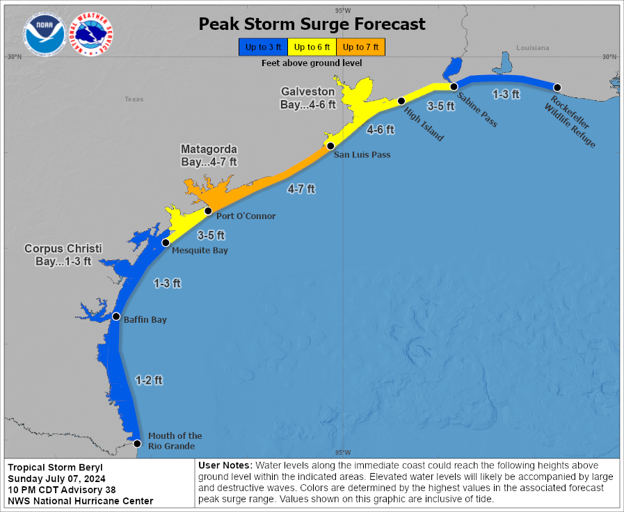
Storm surge
Storm surge flooding, on top of high tides on Monday morning, will probably be a bit higher than what our region experienced during Tropical Storm Alberto in many places near and east of where Beryl comes ashore, especially between Galveston and East Matagorda Bay. These flood waters should quickly recede by Monday afternoon or evening as Beryl lifts northward.
Final thoughts
Wherever you’re reading this, I hope you’ve made it home or to a safe place tonight. While this is unlikely to be a catastrophic storm, it still will be memorable due to the fact that Beryl’s center will pass directly over parts of the southwest, western, and northern Houston metro area, and make for a wild night of winds and rain. If at all possible, please stay put through the morning hours on Monday.
Matt will have a post early on Monday, when Beryl makes landfall, and refreshing the forecast. Then, around 6 am CT on Monday, we’ll have a comprehensive update on the storm and its impacts for our region. That will be followed by regular reports on Monday as we get through the worst of the storm, and onto brighter days ahead.

Still no warning signs of other possible tropical storms in the Atlantic area so far?
Don’t want to jinx anything, but the tropics look to go in a bit of a lull after Beryl. It’s not clear how long it will last.
What happened to Invest 96? I think it was? Is it still there?
Invest 96L is out there.
No. It’s gone now. It dropped off yesterday or the day before.
SETX meteorologists noted a high will deflect storms for a time after this.
The thought that keeps coming to my mind is to compare it to Hurricane Nicholas from 2021. That one, as I recall, made landfall right around the same spot, moved through the area without about the same level of haste, and was around the same level of intensity as most plots seem to put Beryl at around landfall.
The difference all being that Nicholas sort of rode up the coast in more of a east-northeast path, while Beryl looks like it’s going…barrel (let me have my pun!) due north through the city. So I’d imagine the damage more widespread, but comparable? (I was without power for 3-4 days, I think, for Nicholas, and both was and am in Houston city limits…)
/s/ excited to see the spring branch are get another round of 70+mph winds for the second time in two months. /s/. Hopefully the power stays on and if it doesn’t, I hope that it doesn’t take another 6 days for it to be restored.
Thank you for keeping us so well informed! Be safe!
I so appreciate a person is accurate and true. Do you accept small monetary dottions for your good work?
They do a drive every year during November.
SCW runs an annual drive to raise funds.
As always, thanks for keeping us informed. Interesting that the track is continuing to wobble eastward. Last, I recall, was through Fulshear and now it’s closer to 6. Wondering if we will continue to see a bit more shift bringing it closer to the Loop between now and 4am.
Regardless of where she ends up, here’s hoping that a bit of property damage and some short-lived power outages are the worst of it.
Thank you Eric and Matt for keeping us updated and as informed as can be with this dynamic and changing weather.
Just curious, are your thoughts on isolated tornados extreme? And if they happen will they be severe? Worried about going to sleep tonight
Usually tornadoes created by hurricanes are very small and brief, they’re not like the ones you get in the Midwest.
I so appreciate the educated and realistic comments on your website. Thank you!
Thank you for staying up and taking rotations! I’ll be praying through the night. May we all stay safe and make wise choices in the next 24 hours. I’ll wait for the next update. What are the odds of tornadoes..? Just curious. We are in the Brazoria and Harris border.
10:45 in Angleton and we are starting with those spiral rain bands. Gonna get nasty pretty soon.
Thanks as always. Most of the news seems to have it going through Houston proper now? What are the chances it keeps tracking east away from central fort bend?
It’s getting pretty late in the game for major changes, but certainly some slight additional eastward movement is possible.
Thank you guys, for all you do. You are greatly appreciated!
I really can’t thank you (Eric and Matt) enough for this analysis and timely updates. It’s a great reference to assuage my anticipatory anxiety in the days of waiting and useful for my out of town family as well who are more likely to see national news footage of the worst possible scenarios.
Harvey was in 2017, not 2018.
We’re in Brookshire. Looks like the eye will be to our east. Any chance we’ll fare better here and in sealy than Katy/ west Houston?
I think typically the strongest winds are on the right side of the storm, they tend to get a boost from the system’s forward momentum, which also results in slighter lower winds on the left side, since they’re blowing against that forward motion. So if the track remains as is, we should see a bit less wind than the Houston metro, but we’re still going to be close enough to the center of circulation to experience significant blowing. I’m looking at an interactive wind map right now, on the eastern side it’s indicating sustained wind speeds up to 60mph, while on the western side it tops out around 40, but remember, there will also be short-lived, higher gusts occuring throughout the storm.
Thank you Matt and Eric.
Here’s to the blessing of that dry air.
Be safe everyone.
Really appreciate the level-headed approach but am almost in awe of your skill of writing. So concise yet packed with information. I seriously would read a book you wrote about the making of Space City Weather, discussions you and Matt had watching Harvey unfold and the such. Please consider it!
As always, thank you for all that y’all do to keep everyone safe and informed!
Upgraded to a hurricane at 11PM by NWS
Thank you 👍
Eric/Matt, thank you truly for always bringing neutral weather news without the fluff. Question for those of us without garages: is hail usually not a threat with hurricanes?
You guys are THE BEST!
Always professionally informative, yet comforting. You stay safe also!
David and family in Sienna.
Please continue to discuss the wind. The NWS and KPRC , KTRK ,frankly suck. I can not even find a discussion on the wind on those sites.
Thanks
Gary
Bless you all…
Just now heard the wind howling here near i45N and Beltway 8. Batten down the hatches lads, it’s on its way.
Iwish the coastal outline was darker on the map so I could see where the Gulf ended and land began.
Please note when and where storm intensification begins and when and where it reaches its peak.
Great forecasting! I know we were hoping for more southern Texas Landfall. I am worried about the rain but also looking at the wind models and NOAA’s forecast we will have tropical storm wind gusts 40 and above for nearly 12 hours!!! How much damage should we be suspecting? Do not want to sit in the heat for days like with the recent derecho.
its anecdotal, but it seems to me that storms are almost always making landfall at night. even as far back as Alicia (my personal history anyway). is there something to that? and if so, is there an explanation? tsm and tia
Great job Eric and Matt. Once again plenty of time to prep and plenty of up-to-the-minute advice. Seriously, don’t head out until lunchtime at least tomorrow. Hurricane force winds in Katy is no joke for people there and the rest of us on the west side up into Conroe. Check on your neighbors regularly…..This is how we do it here.
It is getting legit frightening in Sweeny. We have lost power and the winds are getting insane. Our yard is flooding pretty bad right now.